Loma Alta (Tarija)
| Loma Alta | ||
|---|---|---|
| Basic data | ||
| Residents (state) | 910 pop. (2012 census) | |
| height | 767 m | |
| Post Code | 06-0302-0101-2001 | |
| Telephone code | (+591) | |
| Coordinates | 21 ° 53 ′ S , 63 ° 46 ′ W | |
|
|
||
| politics | ||
| Department | Tarija | |
| province | Gran Chaco Province | |
| climate | ||
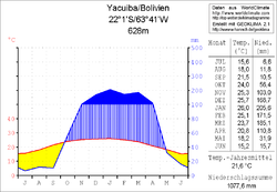
 Climate diagram Yacuiba |
||
Loma Alta is a town in the Tarija Department in the South American Andean state of Bolivia .
Location in the vicinity
Loma Alta is the second largest city of Canton Caraparí in Municipio Caraparí in the southwestern part of the province of Gran Chaco . The village is located at the mouth of the Río El Chorro Grande in the Río Caraparí at an altitude of 767 m between the ridge of the Serranía Aguaragüe in the east and the Serranía Itaú in the west, thirty kilometers northwest of the city of Yacuiba .
geography
Loma Alta is located on the southeast edge of the Bolivian Andes chain in the lowlands of the subtropical Gran Chaco , which stretches across northwest Paraguay , northeast Argentina and southeast Bolivia. The climate is subtropical with hot humid summers and moderately warm and dry winters.
The annual average temperature is almost 22 ° C, the average monthly values fluctuate between 15 ° C in June / July and 26 ° C in January (see Yacuiba climate diagram). Annual precipitation is just under 1100 mm, with a four-month dry season from June to September with monthly precipitation below 15 mm and a humidity period from December to March with 160–200 mm monthly precipitation.
population
The population of the village has almost doubled over the past decade:
| year | Residents | source |
|---|---|---|
| 1992 | no detailed data | census |
| 2001 | 483 | census |
| 2013 | 910 | census |
Transport network
Loma Alta is located at a distance of 251 kilometers by road east of Tarija , the capital of the department.
The Ruta 29 trunk road runs through Caraparí, heading north to Palos Blancos , where it meets Ruta 11 . This leads 173 kilometers to the west and meets the Ruta 1 eight kilometers before Tarija , which from there crosses the entire Altiplano to the north and finally reaches Desaguadero on the Peruvian border via the large cities of Potosí , Oruro and El Alto .
In a southerly direction, three kilometers south of Caraparí, the 169-kilometer-long Ruta 33 begins , which continues via Loma Alta to Bermejo on the Argentine border and from there is connected to the northern Argentine cities of Aguas Blancas and Pichanal via Ruta Nacional 50 .
Individual evidence
- ^ INE - Instituto Nacional de Estadística Bolivia 1992
- ^ INE - Instituto Nacional de Estadística Bolivia 2001
- ^ INE - Instituto Nacional de Estadística Bolivia 2012
Web links
- Relief map 6828-I of the Carapari region 1: 50,000 (PDF; 1.54 MB)
- Relief map of the Villamontes region 1: 250,000 (PDF; 5.68 MB)
- Municipio Caraparí - General Maps No. 60302
- Municipio Caraparí - detailed map and population data (PDF; 638 kB) ( Spanish )
- Departamento Tarija - social data of the municipalities (PDF; 3.05 MB) ( Spanish )
