Loutra Oreas Elenis
|
Loutra Oreas Elenis Λουτρά Ωραίας Ελένης |
||
|---|---|---|
|
|
||
| Basic data | ||
| Country |
|
|
| region | Peloponnese | |
| Regional district | Corinthia | |
| local community | Corinth | |
| Parish | Saronikos | |
| Borough | Galataki | |
| Geographic coordinates | 37 ° 52 ' N , 23 ° 0' E | |
| Height above d. M. |
10 m (center) |
|
| Residents | 1145 (2011) | |
| Post Code | 20100 | |
| Telephone code | 27410 | |
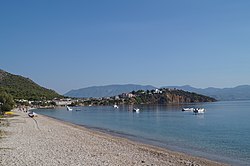
| Loutra Oreas Elenis beach and Cape Kechries | ||
Loutra Oreas Elenis or Loutra Elenis ( Greek Λουτρά Ωραίας Ελένης ( n. Pl. ) = Baths of the beautiful Helena ) is a coastal town in the Greek municipality of Corinth in the Peloponnese . It is located on Ethniki Odos 70 , which runs from Corinth to Argos , about 6 km south of the Corinth Canal .
description
The place is on the Kechries peninsula and on the beach south of it. In the last 30 years the number of inhabitants has tripled and the settlement now meets the neighboring village of Kato Almyri in the south and is only separated from it by the bed of a dried-up stream. The influx came mainly from Athens , the neighboring town of Galataki and the nearby mountain town of Angelokastro . Many holiday homes were also built, so that the number of residents tripled in summer. About 800 m west of the village on the southern slope of the Oneia Mountains, the Siemens or Mediterranean Village settlement was built, which is owned by the Siemens Corporate Personnel building cooperative .
| year | population |
|---|---|
| 1991 | 409 |
| 2001 | 915 |
| 2011 | 1145 |
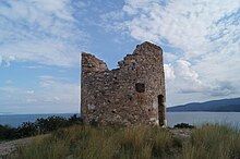
In addition to the long south beach, there is a small beach north of the peninsula. About 100 m north of the beach are the thermal salt springs and the remains of bathing pools. The beautiful Helena , the wife of Menelaus , is said to have bathed here and gave the place its current name. In the northern part of the peninsula there is the small forest of Loutra Oreas Elenis and on the highest point the ruins of a round windmill.
history
There was already a settlement on the Kechries peninsula in the Late Helladic era. 425 BC The Attic general Nikias landed here, between the promontory Chersonese and Loutra Oreas Elenis, which at that time was still called Rheiton, and ravaged the country. It finally came to the battle of Solygeia , in which the Corinthians were able to drive out the Athenians with great losses. In the 4th century BC Fort Stanotopi was built on the Oneia. In the 2nd century the geographer Pausanias visited the place and reported that the bath of Helena was here. A spring is said to have risen from a rock near the sea and the sea is said to have boiled at the point where the spring water mixed with the sea water. In the Middle Ages, the Venetians built a fortification on the Oneia, which was partially destroyed by a mine.
During the Second World War , the windmill was used by the Wehrmacht as an artillery position.
literature
- Nikos Papahatzis: The ancient Corinth , Athens 2005, ISBN 960-213-216-7 , p. 44
- Richard Speicher: Peloponnese. 2nd Edition. W. Kohlhammer, Stuttgart / Berlin / Cologne 1980, ISBN 3-17-010031-9 , p. 67
Web links
Individual evidence
- ↑ Results of the 2011 census at the National Statistical Service of Greece (ΕΛ.ΣΤΑΤ) ( Memento from June 27, 2015 in the Internet Archive ) (Excel document, 2.6 MB)
- ↑ Thucydides : The Peloponnesian War 4, 42-45
- ^ Pausanias: Travels in Greece , 2, 2, 3


