
Ludwigshafen district west
Ludwigshafen-West district is the smallest district of Ludwigshafen and first appeared on city maps in 1958. Before that, the term slaughterhouse district was used in residents' registers. In the present boundaries of the district since 1974. West is It consists of parts of the districts Friesenheim , Ludwigshafen and Mundenheim together and is in Ortsbeirat Northern City Center , together with the districts of Nord / Hemshof managed politically.
District boundaries
Although the district is in the immediate vicinity of the city center, Ludwigshafen main station and is connected to the tram line 4 and the bus routes 74, 75, 76 and 78, it is largely isolated from the surrounding districts. The west-east expansion along Frankenthaler Strasse, which leads to Oggersheim , is characteristic. The western part of the city is bounded by the Ludwigshafen-Worms-Mainz railway line in the north, in the south by the A 650 , the bathing lake "Große Blies" and the post office, in the west by the area around the Heinrich-Pesch-Haus (fields and allotments) and in the east by Deutsche Bahn AG track systems.
history

The Rohrlacher Hof was built in 1807 at today's intersection Rohrlachstrasse / Frankenthaler Strasse and then belonged to the Ludwigshafen community from 1843 to 1853 when Ludwigshafen was founded. With the construction of the Palatinate Ludwig Railway in 1847 and the Mainz – Ludwigshafen railway line in 1853, the structure of the West district was decisively determined. Factories and businesses settled along the border of what is now the West district and in the area itself. In 1856 today's main cemetery was created as the central cemetery for Ludwigshafen and the suburbs. The first development was built in 1895 on Amalienstraße, around 1900 along Frankenthaler Straße and around the slaughterhouse. Row houses were built in the 1920s. In 1939 the "Schlachthofviertel" had 3400 inhabitants in 1030 apartments. Also in the district is a bunker of World War II , in 2001, the exhibition "When the fire fell from the sky" harbored. In 1945 20% of the apartments were destroyed in the war.
The Valentin-Bauer-Siedlung was ready for occupancy in 1956. Your name gradually replaced the name "Schlachthof-Viertel". In 1959, shelter for the homeless and emergency shelters were built in Bayreuther Strasse, which were replaced by newer buildings in the late 1960s. In 1961 there were 7,000 residents in 2,030 apartments. The 1960s brought the district the construction of two new churches, the cath. Holy Cross Church and the Protestant Mathäuskirche. In the 1980s, the tram route towards the end of Frankenthaler Strasse was re-routed to the south. As the population was expected to grow rapidly, the new lower-lying tram station Heinrich-Pesch-Haus was built and the street layout for a north-south axis to be built was created. In the 1990s, container shelters for asylum seekers were built on Wollstrasse, which were dissolved in 2007.
Educational and sports facilities
The elementary school assemblies School was built in 1958 as a primary school, 1964, the present school came up with a program focusing on learning school at the Assemblies as "special school" added. In 1970, the Theodor-Heuss-Gymnasium and the Anne-Frank-Realschule were located in the district on the site of the former Holz brickworks . The free Christian Lukas School was founded in 2002, recognized by the state in 2005 and moved in 2009 from a community hall in the Nord / Hemshof district to the new building in the West district. The "Catholic Academy Rhein-Neckar", the Heinrich Pesch House, founded by the Jesuit order, has been located on the cross since 1972 . The Helmut Müller Education Center for retraining, advanced training and qualifications in the fields of metal, wood and construction has been located on the site of the former J. Roth factory since 1979 . There are two after-school care centers and three day-care centers in the district. The district sports facility West was inaugurated in 1977.
Operating location today
The company for electrical wholesaling Moster, founded in 1946, has its headquarters in West. Since 1911, the company Jean Engelsmann, which moved to Ludwigshafen am Rhein around 1900, has its headquarters in Frankenthaler Strasse. She began here in the mechanical engineering division for mills and further developed her products after the Second World War, adapted to the market in the form of sieving, conveying and mixing technology for bulk goods made of plastic.
In 1984 the cable pilot project in Ludwigshafen started. The private broadcasters with the Sat.1 predecessor and 1985/1986 Radio RPR (Rheinland-Pfälzische Rundfunk GmbH & Co. KG) began broadcasting. The state center for media and communication (LMK), the successor to the state center for private broadcasters (LPR), is also located in the West district. Florists and stonemasons, the West recycling center and a depot of the Ludwigshafen am Rhein commercial enterprise (WBL) are located in the district ). Two brightly painted spherical gas tank of TWL on the edge of the district limits were visible from afar and become something of a landmark for the district, which the demolition, however, did not prevent. Various companies in the car trade and car service characterize the district.
Former establishments
The iron foundry and machine factory of Johannes Roth AG was built as a mechanical workshop in 1860 and was later a supplier for BASF. The machine factory for small backhoe excavators Willy Ertmer was last based here. In 1897 the Ludwigshafen brickworks were founded by Heinrich Holz in the area of what is now the West district.
The municipal slaughterhouse went into operation in 1905, and a wholesale meat market opened on the site in 1963, which closed ten years later. The buildings and facilities are now used as a location for various companies, as well as for restaurants and the Samaritan Workers' Association .
The storage operations of the Palatinate skin recycling started in 1925 in a wooden barrack built in the Ludwigshafen slaughterhouse. In 1927, a property of its own in Krummlachstrasse was acquired and used. From 1934 to 1945, the skin management was under the control of the leather industry monitoring agency. In 1948, the Palatinate skin recycling continued operations. Various successor companies were founded in 1981 and the property was rented out by the Betriebs-GmbH in 1982. The city of Ludwigshafen am Rhein became the leaseholder of the storage rooms and the courtyard area, while the Palatinate Butchers Association rented the office wing until 1996. This area is currently used as a mosque.
Newer urban development
The framework plan for urban development from 1993 envisaged the further development of part of the western part of the city with the “West Development Axis” (117 hectares) with further residential and commercial developments. In 2003 the plan was changed due to the lack of demand for multi-storey apartments and the importance of the area for the urban climate . The proportion of commercial space and green space was increased. A former farm building is now the Alemi Islam Mosque.
Part of the district (northern axis and eastern part) was included in the Socially Integrative City program in 2001. There is a West Interest Group (IG West) that has been looking after the district since 1998. In addition, the west redevelopment area started in 2001. Among other things, the multi-family houses built by IG-Farben (BASF) along Frankenthaler Strasse (near the main cemetery) and other private properties were renovated. The Catholic Church Heilig Kreuz was abandoned in 2006. Container accommodation for asylum seekers built on Wollstrasse in the 1990s was closed in 2007.
photos

Bunker Ludwigshafen-West

Water tower at the slaughterhouse

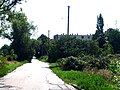
Valentin-Bauer-Strasse

former cath. Church of the Holy Cross

ev. Mathäuskirche

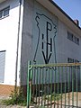
former factory building by J. Roth, later by W. Ertmer

Houses built around 1900
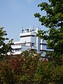
Heinrich Pesch House (HPH)

Stop HPH

Road layout at the HPH
Bayreuther Strasse
former Palatinate hide exploitation

old and new buildings
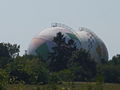
gas tank


literature
- History of the city of Ludwigshafen am Rhein. 2 volumes. Verlag Stadt Ludwigshafen Stadtarchiv, 2003. ISBN 978-3-924667-35-1 .
- Development of the West district in the last 20 years, information on urban development Ludwigshafen 15/91, City of Ludwigshafen.
- Church leader Ludwigshafen, city planning city of Ludwigshafen.
Web links
- http://www.ludwigshafen.de
- http://www.pesch-bildet.de/
- https://www.engelsmann.de/siebmaschinen-steller/historie
- http://www.bzmueller.de/
- http://www.weg-ludwigshafen.de/index.php?id=29
- http://www.ig-west.de
- 100 years of city statistics in Ludwigshafen am Rhein. Retrieved November 5, 2019 .
Individual evidence
- ^ Werner Appel: 100 years of city statistics in Ludwigshafen am Rhein . In: City of Ludwigshafen am Rhein (ed.): Information on urban development . Ludwigshafen am Rhein, p. 98-100 .

Friesenheim (Froschlache) | Garden city (Hochfeld, Niederfeld, Ernst-Reuter-Siedlung) | Maudach | Mundenheim | Northern city center (North, Hemshof , West ) | Oggersheim (Melm, Notwende ) | Oppau ( Edigheim , Pfingstweide ) | Rheingönheim | Ruchheim | Southern city center (center, south)
Coordinates: 49 ° 28 ′ 48 ″ N , 8 ° 25 ′ 26 ″ E