
Luttringhausen (Bad Münder am Deister)
|
Luttringhausen
City of Bad Münder am Deister
|
||
|---|---|---|
 |
||
| Height : | 169 m | |
| Residents : | 178 (2012) | |
| Incorporation : | 1st January 1973 | |
| Postal code : | 31848 | |
| Area code : | 05042 | |
Location of Luttringhausen in Lower Saxony |
||

Luttringhausen is one of 16 districts of the city of Bad Münder am Deister ( Hameln-Pyrmont district , Lower Saxony ).
Geographical location
Luttringhausen is located in the northern part of the city of Bad Münder am Deister , in the Weserbergland . The closest neighboring districts are Eimbeckhausen in the northwest , Böbber in the southwest and Nettelrede in the southeast . The federal highway 442 runs from Bad Münder to the federal highway 2 connection near Lauenau .
history
The Luttringhausen manor was mentioned in 1406 as owned by the von Wettberg family. In 1644 it came into the possession of the von Lenthe people who still live here and manage the estate. The facility is now a listed building.
The village of Luttringhausen was united on January 1, 1973 through the regional reform as one of 16 districts to the municipality of Bad Münder.

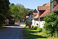
Village center
To the manor

On the spot

Bus stop in front of the manor
_IMG_6550.jpg)
_IMG_6555.jpg)
_IMG_6541.jpg)
_IMG_6557.jpg)
politics
Luttringhausen has a joint local council with the neighboring town of Nettelrede.
Local mayor is Gerd Ahrens (SPD).
Web links
Individual evidence
- ↑ www.hannover.de: Rittergut Luttringhausen , accessed on April 28, 2019
Bad Münder | Bakede | Beber | Böbber | Brullsen | Egestorf (Süntel) | Eimbeckhausen | Carnage | Hachmühlen | Hamelspringe | Hasperde | Klein Süntel | Luttringhausen | Slip speech | Nienstedt | Rohrsen