Luzoué
|
Luzoué Luzouré |
||
|
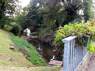
The river at Mourenx |
||
| Data | ||
| Water code | FR : Q5360500 | |
| location | France , Nouvelle-Aquitaine region | |
| River system | Adour | |
| Drain over | Gave de Pau → Gaves Réunis → Adour → Atlantic Ocean | |
| source | in the municipality of Monein 43 ° 16 ′ 2 ″ N , 0 ° 34 ′ 8 ″ W |
|
| Source height | approx. 187 m | |
| muzzle | on the municipal boundary of Lagor and Mont in the Gave de Pau Coordinates: 43 ° 24 ′ 0 ″ N , 0 ° 38 ′ 51 ″ W 43 ° 24 ′ 0 ″ N , 0 ° 38 ′ 51 ″ W |
|
| Mouth height | approx. 84 m | |
| Height difference | approx. 103 m | |
| Bottom slope | approx. 4.9 ‰ | |
| length | approx. 21 km | |
| Left tributaries | Lèze | |
The Luzoué (also spelled Luzouré ) is a river in France that runs in the Pyrénées-Atlantiques department in the Nouvelle-Aquitaine region . It rises near the hamlet of Horticous in the southern municipality of Monein , generally drains north-west through the landscape of the historic province of Béarn and flows after about 21 kilometers at the municipal boundary of Lagor and Mont as a left tributary into the Gave de Pau .
Places on the river
(Order in flow direction)
- Féas , municipality of Monein
- Cardesse
- Bachaulet , Monein municipality
- Lahourcade
- Mourenx
- Lagor
- Casanave , Lagor municipality
