
Monein
| Monein | ||
|---|---|---|
.svg)
|
|
|
| region | Nouvelle-Aquitaine | |
| Department | Pyrénées-Atlantiques | |
| Arrondissement | Pau | |
| Canton | Le Coeur de Bearn | |
| Community association | Lacq-Orthez | |
| Coordinates | 43 ° 19 ′ N , 0 ° 35 ′ W | |
| height | 109-357 m | |
| surface | 80.84 km 2 | |
| Residents | 4,438 (January 1, 2017) | |
| Population density | 55 inhabitants / km 2 | |
| Post Code | 64360 | |
| INSEE code | 64393 | |
| Website | http://www.monein.fr/ | |
 Park and Castle Monein |
||

Monein ( Basque : Muneiñe , Occitan : Monenh ) is a French municipality with 4438 inhabitants (as of January 1 2017) in the department of Pyrénées-Atlantiques in the region Nouvelle-Aquitaine (before 2016: Aquitaine ). Monein belongs to the Arrondissement Pau (until 2016: Arrondissement Oloron-Sainte-Marie ) and the canton Le Cœur de Béarn (until 2015: capital of the canton Monein ). The inhabitants are called Moneinchons .
geography
Monein is located in the historic province of Béarn on the rivers Baysère and Luzoué as well as other small rivers. Monein is surrounded by the neighboring communities of Lahourcade in the north and northwest, Pardies in the north, Parbayse , Cuqueron , Arbus , Aubertin and Lacommande in the east, Lasseube in the southeast, Estialescq and Goes in the south, Precilhon and Cardesse in the southwest and Lucq-de-Béarn in the West.
Population development
| year | 1962 | 1968 | 1975 | 1982 | 1990 | 1999 | 2006 | 2011 | 2017 |
| Residents | 3,563 | 3,967 | 3,865 | 3,879 | 4.032 | 4.183 | 4,367 | 4,484 | 4,438 |
| Source: Cassini and INSEE | |||||||||
economy
The wine-growing regions of Béarn and Jurançon extend into the municipality. Viticulture and cheese making are the town's main sources of income.
Attractions
- Saint-Girons church from the 15th / 16th centuries Century, built in Gothic style, monument historique since 1913
- Monein Castle and Park
- Market hall
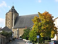
Saint-Girons church

Market hall


Personalities
- Raymond de Saint-Sever (? –1317), Bishop of Oloron, Cardinal (from 1312) under Clement V, born in Monein