
Uzan (Pyrénées-Atlantiques)
| Uzan | ||
|---|---|---|
|
||
| region | Nouvelle-Aquitaine | |
| Department | Pyrénées-Atlantiques | |
| Arrondissement | Pau | |
| Canton | Artix and Pays de Soubestre | |
| Community association | Luys en Bearn | |
| Coordinates | 43 ° 29 ′ N , 0 ° 30 ′ W | |
| height | 102-148 m | |
| surface | 6.20 km 2 | |
| Residents | 176 (January 1, 2017) | |
| Population density | 28 inhabitants / km 2 | |
| Post Code | 64370 | |
| INSEE code | 64548 | |
 Uzan City Hall |
||

Uzan is a French municipality with 176 inhabitants (at January 1, 2017) in the department of Pyrénées-Atlantiques in the region Nouvelle-Aquitaine (before 2016: Aquitaine ). The community belongs to the Arrondissement Pau and Canton Artix et Pays de Soubestre (2015: Canton Arzacq-Arraziguet ).
geography
Uzan is located about 25 km northwest of Pau in the historical province of Béarn on the northern edge of the department.
In addition to the main settlement, Uzan also includes the hamlets Lavignasse and Morlanne.
Uzan is surrounded by the neighboring communities:
| bouillon | Garos | |
| Géus-d'Arzacq |
.svg)
|
Larreule |
| Arnos | Boumourt | Mazerolles |
Uzan is located in the catchment area of the Adour River .
The Luy de Béarn flows through the area of the municipality together with its tributary, the Uzan , which flows into the Luy here.
history
At the end of the 13th century the Benedictine monks from Larreule encouraged the establishment of a bastide in the village of Uzan. A certain geometry in the structure of the center of the community still testifies to this today. The 1385 census in Béarn counted 23 households in Uzan. The village belonged to the Bailliage of Pau. In the 16th century the residents swore an oath to the monastery of Larreule, which allowed them to use the land for an annual fee.
Toponyms and mentions of Uzan were:
- Usan (12th century, according to Pierre de Marca's book Histoire de Béarn , p. 267),
- Usan (1409, documents of the Viscount des Béarn, E. 2620),
- Sente-Quiterie d'Usan (1487, notaries from Larreule, No. 2, sheet 15),
- Ussan (1505, notaries from Garos),
- Usan (1750, map by Cassini),
- Uzan (1793, Notice Communale ),
- Usan (1801, Bulletin des lois ) and
- Uzan (1863, Dictionnaire topographique du département des Basses-Pyrénées).
Population development
After the records began, the population rose to a peak of around 350 in the first half of the 19th century. In the following period, the size of the community stagnated to around 235 by the 1870s, recovered briefly in the 1880s to around 275, before a prolonged phase of population decline set in that lasted into the first decade of the 21st century. Recently, however, a recovery phase could have started again.
| year | 1962 | 1968 | 1975 | 1982 | 1990 | 1999 | 2006 | 2010 | 2017 |
|---|---|---|---|---|---|---|---|---|---|
| Residents | 171 | 166 | 146 | 164 | 156 | 153 | 151 | 151 | 176 |

Attractions


- Parish church dedicated to Saint Quiteria. It was built below the center of the community, not far from the source of St. Quiteria. Although it was first mentioned in the records in 1487, this pilgrimage site is older and is believed to date from the 12th century. Extensive restorations and alterations took place in the 19th and 20th centuries. The side chapels date from the 14th or 15th century and open to the single-nave nave via two pointed arches that are framed with beveled stone . The church holds u. a. two side altars from the 18th century, registered as national treasures. For a long time, the source of the holy Quiteria had a reputation for helping against eye diseases and toothache and headaches. It was mentioned like the church in 1487, but the devotion took place earlier. The spring, which was restored in the 20th century, now presents itself as a stone niche that opens into a shallow water basin on the slope, which is filled with very clear water.

View of the choir

View of the apse
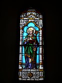
Stained glass window with Franz von Sales

Stained glass window with the motif of the Assumption of Mary


Economy and Infrastructure
Agriculture is traditionally the most important economic factor in the municipality.

total = 35

education
The municipality has a public primary school with 22 pupils in the 2017/2018 school year.
sport and freetime
The long-distance hiking trail " GR 65" from Geneva to Roncesvalles leads through the municipality. From Le Puy-en-Velay it follows the Via Podiensis , one of the four historic routes of the pilgrims in France .
traffic
Uzan can be reached via Routes départementales 49, 262, 276 and 945, the former Route nationale 645 .
Web links
Individual evidence
- ↑ Ma commune: Uzan ( fr ) Système d'Information sur l'Eau du Bassin Adour Garonne. Retrieved January 4, 2018.
- ↑ a b Uzan ( fr ) Conseil régional d'Aquitaine. Archived from the original on January 4, 2018. Info: The archive link was automatically inserted and has not yet been checked. Please check the original and archive link according to the instructions and then remove this notice. Retrieved January 4, 2018.
- ^ A b Paul Raymond: Dictionnaire topographique du département des Basses-Pyrénées ( fr ) In: Dictionnaire topographique de la France . Imprimerie nationale. P. 172, 1863. Retrieved January 4, 2018.
- ^ David Rumsey Historical Map Collection France 1750 ( en ) David Rumsey Map Collection: Cartography Associates. Retrieved January 4, 2018.
- ↑ a b Notice Communale Uzan ( fr ) EHESS . Retrieved January 4, 2018.
- ↑ Populations légales 2015 Commune d'Uzan (64548) ( fr ) INSEE . Retrieved January 4, 2018.
- ↑ Eglise Sainte-Quitterie d'Uzan ( fr ) Conseil régional d'Aquitaine. Archived from the original on January 4, 2018. Info: The archive link was automatically inserted and has not yet been checked. Please check the original and archive link according to the instructions and then remove this notice. Retrieved January 4, 2018.
- ↑ église paroissiale Sainte-Quitterie. ( fr ) Ministry of Culture and Communication . Retrieved January 4, 2018.
- ↑ Fontaine Sainte-Quitterie d'Uzan ( fr ) Conseil régional d'Aquitaine. Archived from the original on January 4, 2018. Info: The archive link was automatically inserted and has not yet been checked. Please check the original and archive link according to the instructions and then remove this notice. Retrieved January 4, 2018.
- ↑ Caractéristiques des établissements en 2015 Commune d'Uzan (64548) ( fr ) INSEE . Retrieved January 4, 2018.
- ^ École élémentaire ( fr ) National Ministry of Education. Retrieved January 4, 2018.
- ^ Bettina Forst: French Way of St. James. From Le Puy-en-Velay to Roncesvalles. All stages - with variants and height profiles. Bergverlag Rother, Munich (recte: Ottobrunn) 2007, ISBN 978-3-7633-4350-8 ( Rother hiking guide ). P. 155
- ↑ GR® 65, le chemin de Compostelle via le Puy ( fr ) Fédération française de la randonnée pédestre . Retrieved August 28, 2017.
← Previous location: Fichous-Riumayou 6.1 km | Uzan | Next town: Pomps 4.4 km →