Ribarrouy
| Ribarrouy | ||
|---|---|---|
|
|
||
| region | Nouvelle-Aquitaine | |
| Department | Pyrénées-Atlantiques | |
| Arrondissement | Pau | |
| Canton | Terres des Luys et Coteaux du Vic-Bilh | |
| Community association | Luys en Bearn | |
| Coordinates | 43 ° 31 ′ N , 0 ° 16 ′ W | |
| height | 170-231 m | |
| surface | 2.27 km 2 | |
| Residents | 83 (January 1, 2017) | |
| Population density | 37 inhabitants / km 2 | |
| Post Code | 64330 | |
| INSEE code | 64464 | |
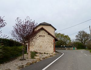
 Ribarrouy Town Hall |
||
Ribarrouy is a French municipality with 83 inhabitants (at January 1, 2017) in the department of Pyrénées-Atlantiques in the region Nouvelle-Aquitaine (before 2016: Aquitaine ). The municipality belongs to the Arrondissement of Pau and the canton of Terres des Luys et Coteaux du Vic-Bilh (until 2015: canton Garlin ).
The origin of the name comes from the Gascognischen words (ar) riu ( German Bach ) and arroi ( German red ). The landscape around the municipality does not allow any explanation for this origin.
geography
Ribarrouy is located about 30 km north of Pau in the Vic-Bilh region of the historic province of Béarn on the northeastern edge of the department.
The place is surrounded by the neighboring communities:
| Boueilh-Boueilho-Lasque | Garlin | |

|
Taron-Sadirac-Vlichenave | |
| Claracq |
Ribarrouy is located in the catchment area of the Adour River . The Gabassot, a tributary of the Lées , crosses the territory of the municipality.
history
Barrows that were discovered in the municipality show an early settlement of the area. These are mainly located along the ancient road that led from the Chalosse, a stretch of land in the southern part of what is now the Landes department , to Saint-Pé-de-Bigorre . Funerary urns were found in these graves. In the Middle Ages there was a lay monastery in the village. The abbot and the landlord of Ribarrouy fought for a long time to claim all or part of the tithe for themselves. The abbot Jacques de Trescens was finally granted the right to the basic rule under the condition in the 17th century that he the fealty against the sovereign swear by Béarn.
Toponyms and mentions of Ribarrouy were:
- Riverouy and Arriberoy (1675, reformation de Béarn , manuscript collection from the 16th to 18th centuries),
- Ribarrouy (1750 and 1783, map by Cassini or Notice Communale ),
- Ribarony (1801, Bulletin des Lois ) and
- Ribarrouy (1863, Dictionnaire topographique de la France).
Population development
After a peak in the number of inhabitants of around 150 in the middle of the 19th century, the number fell to around 60 during short periods of recovery up to the 1940s. Since then, a slight upward trend has been recorded.
| year | 1962 | 1968 | 1975 | 1982 | 1990 | 1999 | 2006 | 2009 | 2017 |
|---|---|---|---|---|---|---|---|---|---|
| Residents | 70 | 76 | 68 | 69 | 78 | 78 | 82 | 81 | 83 |
Attractions
- Parish church, consecrated to Germanus of Auxerre . From the original church, built in the 12th century, only the general structure and the stone altar remain due to extensive renovations in the 16th and 17th centuries . A project to restore the timbers was carried out in 1867. The roof of the church is covered with interlocking tiles. This points to a restoration of the roof in the second half of the 19th century, as this type of roof tile was only produced since then. The single-nave nave of the current building is closed off to the west with a bell gable. The gilded tabernacle is probably made of chestnut wood and decorated with four serpentine columns in its corners. It is similar to the tabernacle in Castetpugon . The large painting in the background measures 1.88 m high and 1.91 cm wide. It shows Christ crucified with John the Baptist and Germanus of Auxerre on both sides. Many other furnishings inside the church date from the 17th to 19th centuries and are registered as national cultural assets.
Economy and Infrastructure

Total = 12
traffic
Ribarrouy is crossed by Route départementale 42.
Web links
- Atlas du Patrimoine Historique et Culturel with pictures from Ribarrouy (French)
- Website of the tourist office "LEMBEYE & GARLIN" for the Vic-Bilh region (French)
Individual evidence
- ↑ a b Ribarrouy ( fr ) visites.aquitaine.fr. Archived from the original on November 14, 2017. Info: The archive link was inserted automatically and has not yet been checked. Please check the original and archive link according to the instructions and then remove this notice. Retrieved November 14, 2017.
- ↑ Ma commune: Ribarrouy ( fr ) Système d'Information sur l'Eau du Bassin Adour Garonne. Retrieved November 14, 2017.
- ^ Paul Raymond: Dictionnaire topographique du département des Basses-Pyrénées ( fr ) In: Dictionnaire topographique de la France . Imprimerie nationale. Pp. 142, 1863. Retrieved November 14, 2017.
- ^ David Rumsey Historical Map Collection France 1750 ( en ) David Rumsey Map Collection: Cartography Associates. Retrieved November 14, 2017.
- ↑ a b Notice Communale Ribarrouy ( fr ) EHESS . Retrieved November 14, 2017.
- ↑ Populations légales 2014 Commune de Ribarrouy (64464) ( fr ) INSEE . Retrieved November 14, 2017.
- ↑ Église Saint-Germain-d'Auxerre de Ribarrouy ( fr ) visites.aquitaine.fr. Archived from the original on November 14, 2017. Info: The archive link was inserted automatically and has not yet been checked. Please check the original and archive link according to the instructions and then remove this notice. Retrieved November 14, 2017.
- ^ Eglise paroissiale Saint-Germain-d'Auxerre ( fr ) Ministry of Culture and Communication . Retrieved November 14, 2017.
- ↑ Caractéristiques des établissements en 2015 Commune de Ribarrouy (64464) ( fr ) INSEE . Retrieved November 14, 2017.


