Arget (Pyrénées-Atlantiques)
| Arget | ||
|---|---|---|
|
|
||
| region | Nouvelle-Aquitaine | |
| Department | Pyrénées-Atlantiques | |
| Arrondissement | Pau | |
| Canton | Artix and Pays de Soubestre | |
| Community association | Luys en Bearn | |
| Coordinates | 43 ° 33 ′ N , 0 ° 32 ′ W | |
| height | 75-182 m | |
| surface | 4.00 km 2 | |
| Residents | 78 (January 1, 2017) | |
| Population density | 20 inhabitants / km 2 | |
| Post Code | 64410 | |
| INSEE code | 64044 | |
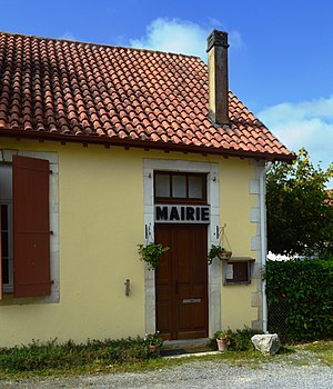
 Arget Town Hall |
||
Arget is a French municipality with 78 inhabitants (at January 1, 2017) in the department of Pyrénées-Atlantiques in the region Nouvelle-Aquitaine . The community belongs to the Arrondissement Pau and Canton Artix et Pays de Soubestre (2015: Canton Arzacq-Arraziguet ).
The inhabitants are called Argétois .
geography
Arget is about 45 kilometers north of Pau in a wooded valley on the border with the neighboring Landes department .
The community is surrounded by the neighboring communities:
- Montagut in the east,
- Morlanne and Piets-Plasence-Moustrou in the south,
- Casteide-Candau in the southwest as well
- Monget (Landes) in the northwest.
Arget lies in the catchment area of the Adour River . The Hourquet rises in the local area and marks a large part of the municipality boundary to Monget in the northwest. The brook Rance flows on the municipal boundary to Montegut in the east.
history
Paul Raymond, archivist and historian of the 19th century, noted the mention of the settlement under the name Argiet in 1383 and that the village belonged to the Commandery of the Order of St. John of Caubin and Morlaàs in 1695 under the name Arzet .
Population development
| year | 1962 | 1968 | 1975 | 1982 | 1990 | 1999 | 2006 | 2009 | 2014 |
|---|---|---|---|---|---|---|---|---|---|
| Residents | 110 | 99 | 100 | 97 | 79 | 83 | 89 | 93 | 83 |
Attractions
- Church of Our Lady , dedicated to Mary the Mother of Jesus . There is much evidence that the origins of the village lie in an 11th century fortified settlement. The local church with its cemetery is located on an almost square hill on which a mound castle stood. Two adjacent streets are now laid out on the site of trenches. The original, Romanesque style church was built in the 12th century and redesigned in the 15th century, as evidenced by the bell tower with buttresses and a wall opening in the shape of a pointed arch in the apse . The building was restored in the 19th and 20th centuries.
Economy and Infrastructure

total = 18
traffic
Arget is connected to the routes départementales 264 and 365.
Web links
Individual evidence
- ↑ Pyrénées-Atlantiques Gentile ( fr ) habitant.fr. Retrieved January 18, 2017.
- ↑ Ma commune: Arget ( fr ) Système d'Information sur l'Eau du Bassin Adour Garonne. Retrieved January 18, 2017.
- ^ Paul Raymond: Dictionnaire topographique du département des Basses-Pyrénées ( fr ) In: Dictionnaire topographique de la France . Imprimerie nationale. P. 10. 1863. Retrieved January 18, 2017.
- ↑ Notice Communale Arget ( fr ) EHESS . Retrieved January 18, 2017.
- ↑ Populations légales 2014 Commune d'Arget (64044) ( fr ) INSEE . Retrieved January 18, 2017.
- ↑ église paroissiale Notre-Dame. ( fr ) Ministry of Culture and Communication . Retrieved January 18, 2017.
- ↑ Caractéristiques des établissements en 2014 Commune d'Arget (64044) ( fr ) INSEE . Retrieved on January 18, 2017. ( Page no longer available , search in web archives ) Info: The link was automatically marked as defective. Please check the link according to the instructions and then remove this notice.


