Boueilh-Boueilho-Lasque
| Boueilh-Boueilho-Lasque | ||
|---|---|---|
|
|
||
| region | Nouvelle-Aquitaine | |
| Department | Pyrénées-Atlantiques | |
| Arrondissement | Pau | |
| Canton | Terres des Luys et Coteaux du Vic-Bilh | |
| Community association | Luys en Bearn | |
| Coordinates | 43 ° 33 ′ N , 0 ° 19 ′ W | |
| height | 117-263 m | |
| surface | 17.35 km 2 | |
| Residents | 348 (January 1, 2017) | |
| Population density | 20 inhabitants / km 2 | |
| Post Code | 64330 | |
| INSEE code | 64141 | |
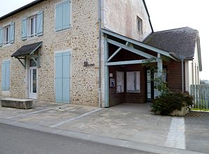
 Town hall ( Mairie ) of Boueilh-Boueilho-Lasque |
||
Boueilh-Boueilho-Lasque ( Occitan Buelh, Buelhòu e Lasque ) is a French commune of the department Pyrénées-Atlantiques with 348 inhabitants (as of January 1 2017) in the region Nouvelle-Aquitaine . Administratively, it is assigned to the canton of Terres des Luys et Coteaux du Vic-Bilh (until 2015: canton of Garlin ) and the arrondissement of Pau .
geography
Boueilh-Boueilho-Lasque is located about 27 kilometers north-northeast of Pau in the Béarnaise . Boueilh-Boueilho-Lasque is surrounded by the neighboring municipalities of Lauret in the north, Garlin in the east and northeast, Ribarrouy in the southeast, Claracq in the south, Garlède-Mondebat in the west and southwest, Conblucq in the west and Poursiugues-Boucoue in the northwest.
The A65 autoroute and the former national route 134 (today's D834) run through the municipality .
Population development
| year | 1936 | 1946 | 1954 | 1962 | 1968 | 1975 | 1982 | 1990 | 1999 | 2006 | 2013 |
|---|---|---|---|---|---|---|---|---|---|---|---|
| Residents | 439 | 411 | 389 | 350 | 347 | 302 | 283 | 323 | 329 | 342 | 346 |
| Source: Cassini and INSEE | |||||||||||
Attractions
- Saint-Aignan church in Boueilh, built in 1850
- Saint-Jean church in Boueilho
- Saint-Martin church in Lasque, built in the early 20th century
- Lasque-Fortisson castle from the 18th century

