Momas
|
Momas Monmans |
||
|---|---|---|

|
|
|
| region | Nouvelle-Aquitaine | |
| Department | Pyrénées-Atlantiques | |
| Arrondissement | Pau | |
| Canton | Artix and Pays de Soubestre | |
| Community association | Luys en Bearn | |
| Coordinates | 43 ° 27 ′ N , 0 ° 27 ′ W | |
| height | 126-260 m | |
| surface | 14.51 km 2 | |
| Residents | 577 (January 1, 2017) | |
| Population density | 40 inhabitants / km 2 | |
| Post Code | 64230 | |
| INSEE code | 64387 | |
| Website | http://momas.fr/ | |
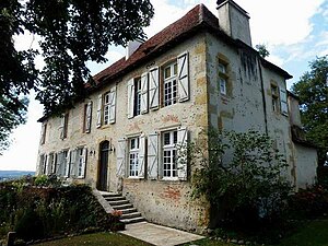
 Château de Momas |
||
Momas ( Occitan : Monmans ) is a French commune of the department Pyrénées-Atlantiques with 577 inhabitants (as of January 1 2017) in the region Nouvelle-Aquitaine . Administratively it is assigned to the canton of Artix et Pays de Soubestre (until 2015: canton of Lescar ) and the Arrondissement of Pau . The inhabitants are called Momasiens .
geography
Momas is located at the foot of the Pyrenees , 17 kilometers north-northwest of Pau on the Luy de Béarn River . Momas is surrounded by the neighboring communities Larreule in the north and north-west, Lonçon in the north and north-east, Bournos in the east and north-east, Aubin in the east, Uzein in the south and south-east, Vlichenave-d'Arthez in the south-west and Mazerolles in the west.
The A65 autoroute runs through the south of the municipality .
Population development
| year | 1936 | 1946 | 1954 | 1962 | 1968 | 1975 | 1982 | 1990 | 1999 | 2006 | 2013 |
|---|---|---|---|---|---|---|---|---|---|---|---|
| Residents | 334 | 335 | 321 | 308 | 289 | 300 | 325 | 374 | 391 | 498 | 553 |
| Source: Cassini and INSEE | |||||||||||
Attractions
- Momas Castle from the 16th / 17th centuries Century with park
