MacArthur (Leyte)
| Municipality of MacArthur | ||
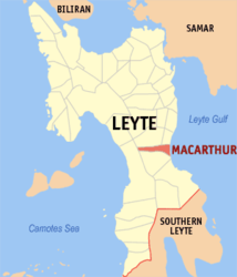
| Location of MacArthur in the Province of Leyte | ||
|---|---|---|

|
||
| Basic data | ||
| Region : | Eastern Visayas | |
| Province : | Leyte | |
| Barangays : | 31 | |
| District: | 2. District of Leyte | |
| PSGC : | 083730000 | |
| Income class : | 5th income bracket | |
| Households : | 3410 May 1, 2000 census
|
|
| Population : | 21,211 August 1, 2015 census
|
|
| Coordinates : | 10 ° 51 ' N , 124 ° 57' E | |
| Postal code : | 6509 | |
| Mayor : | Leonardo B. Leria | |
| Geographical location in the Philippines | ||
|
|
||
MacArthur is a Filipino township in the province of Leyte . It has 21,211 inhabitants ( August 1, 2015 census ).
Barangays
Macarthur is politically divided into 31 barangays .
|
|
|
