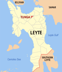
Tunga (Leyte)
| Municipality of Tunga | ||
| Location of Tunga in the Province of Leyte (Province) | ||
|---|---|---|

|
||
| Basic data | ||
| Region : | Eastern Visayas | |
| Province : | Leyte (province) | |
| Barangays : | 8th | |
| District: | 2. District of Leyte (Province) | |
| PSGC : | 083750000 | |
| Income class : | 6th income bracket | |
| Households : |
May 1, 2000 census
|
|
| Population : | 7,584 August 1, 2015 census
|
|
| Population density : | 984.9 inhabitants per km² | |
| Area : | 7.70 km² | |
| Coordinates : | 11 ° 15 ′ N , 124 ° 45 ′ E | |
| Postal code : | 6528 | |
| Mayor : | Amando C. Aumento Sr. | |
| Geographical location in the Philippines | ||
|
|
||
Tunga is the smallest Filipino municipality in the province of Leyte on the island of Leyte . It has 7584 inhabitants (August 1st 2015 census) who live in 8 barangays . The community is described as partially urban and belongs to the sixth income bracket of the communities in the Philippines. Your neighboring communities are Carigara in the northwest, Barugo in the north and Jaro in the south.
Barangays
- Astorga (Barrio Upat)
- Balire
- Banawang
- San Antonio (Poblacion)
- San Pedro (Poblacion)
- San Roque (Poblacion)
- San Vicente (Poblacion)
- Sto. Niño (Poblacion)
