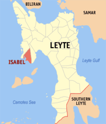
Isabel (Leyte)
| Municipality of Isabel | ||
| Location of Isabel in the Province of Leyte (Province) | ||
|---|---|---|

|
||
| Basic data | ||
| Region : | Eastern Visayas | |
| Province : | Leyte (province) | |
| Barangays : | 24 | |
| District: | 4. District of Leyte (Province) | |
| PSGC : | 083722000 | |
| Income class : | 1st income bracket | |
| Households : |
May 1, 2000 census
|
|
| Population : | 46,915 August 1, 2015 census
|
|
| Population density : | 732.9 inhabitants per km² | |
| Area : | 64.01 km² | |
| Coordinates : | 10 ° 56 ' N , 124 ° 26' E | |
| Postal code : | 6539 | |
| Mayor : | SATURNINO M. MEDINA Jr. | |
| Geographical location in the Philippines | ||
|
|
||
Isabel is a Filipino municipality in the province of Leyte on the island of Leyte . It has 46,915 inhabitants (August 1, 2015 census) who live in 24 barangays . The community is described as partially urban and belongs to the first income bracket of the communities in the Philippines. Your neighboring communities are Palompon in the north, Merida in the east. To the west, the municipality borders the Camotes Sea .
There is a Visayas State University campus in the community .
Barangays
|
|
