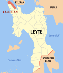
Calubian
| Municipality of Calubian | ||
| Location of Calubian in the Province of Leyte | ||
|---|---|---|

|
||
| Basic data | ||
| Region : | Eastern Visayas | |
| Province : | Leyte | |
| Barangays : | 53 | |
| District: | 3. District of Leyte | |
| PSGC : | 083713000 | |
| Income class : | 4. Income bracket | |
| Households : | 6450 May 1, 2000 census
|
|
| Population : | 31,228 August 1, 2015 census
|
|
| Coordinates : | 11 ° 27 ' N , 124 ° 26' E | |
| Postal code : | 6534 | |
| Geographical location in the Philippines | ||
|
|
||
Calubian is a Filipino municipality in the province of Leyte . It has 31,228 inhabitants (August 1, 2015 census).
Barangays
Calubian is politically divided into 53 barangays .
|
|
|
Web links
- elgu.ncc.gov.ph - Calubian ( Memento from January 13, 2008 in the Internet Archive )
- St. Therese shrine in Calubian ( Memento from January 15, 2008 in the Internet Archive )
