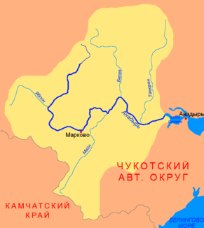
Main (Anadyr)
|
Main Майн |
||
|
Location of the Main (Майн) in the catchment area of the Anadyr |
||
| Data | ||
| Water code | RU : 19050000212119000110807 | |
| location | Chukchi Autonomous Okrug ( Russia ) | |
| River system | Anadyr | |
| Drain over | Anadyr → Bering Sea | |
| source | Penschina Mountains / Korjaken Mountains 62 ° 59 ′ 32 ″ N , 168 ° 54 ′ 27 ″ E |
|
| Source height | 240 m | |
| muzzle |
Anadyr Coordinates: 65 ° 7 ′ 14 " N , 172 ° 14 ′ 20" E 65 ° 7 ′ 14 " N , 172 ° 14 ′ 20" E |
|
| Mouth height | 9 m | |
| Height difference | 231 m | |
| Bottom slope | 0.49 ‰ | |
| length | 475 km | |
| Catchment area | 32,800 km² | |
| Drain |
MQ |
260 m³ / s |
| Left tributaries | Orlovka | |
| Right tributaries | Palwajam, Bolshoi Kuibiwejem, Wajegi , Algan | |
| Navigable | Lower course | |
The Main ( Russian Майн ) is a 475 km long right tributary of the Anadyr in the Far East of Russia .
course
The Main flows from the Mainskoje Lake , which is a few square kilometers in size and is in turn fed by several short streams. The lake is 240 m above sea level near the watershed between the Bering Sea and the Sea of Okhotsk ( Penschina ), between the low Penschina Mountains in the west and the foothills of the Koryak Mountains in the east. It flows in northeast to northern directions through a wide valley in the extremely sparsely populated forest tundra zone . East of the village of Markowo it reaches the swampy and lake-rich central part of the Anadyr lowlands , takes on its extreme right branch Prorwa and then flows almost 100 kilometers almost parallel to the Anadyr to the mouth.
The Main flows through the Anadyr Rajon of the Chukchi Autonomous Okrug along its entire length . The only place on the river is the village of Wajegi on the left bank of the middle reaches with a few hundred mainly Chukchi inhabitants (the entire 249,700 km² large Rajon has only 7,000 inhabitants).
Hydrography
The catchment area of the Main covers 32,800 km². The mean monthly water flow is about 260 m³ / s (maximum monthly mean in the middle reaches, near Wajegi, during the snowmelt in June about 1000 m³ / s).
Near the mouth, the river is about 500 meters wide and three meters deep; it has a flow velocity of 0.5 m / s here.
The most important tributaries are Palwajam, Bolshoi Kuibiwejem, Wajegi and Algan from the right and the Orlowka from the left.
The Main freezes between mid-October and the end of May.
fauna
The Main is a spawning area for sockeye salmon (Oncorhynchus nerka) and ketal salmon (Oncorhynchus keta) .
Infrastructure
The lower reaches of the Main are navigable for smaller vehicles, but because of its location in a sparsely populated area, it is not regularly used for inland navigation.
There is practically no transport infrastructure in the river's catchment area.
