
Malgorou
Location of Malgorou in Niger |

Malgorou is a village in the Yélou rural community in Niger .
The village, led by a traditional local chief ( chef traditionnel ), is located on the edge of the periodically water-bearing dry valley Dallol Foga in the Dendi region . Malgorou is located about 15 kilometers as the crow flies southwest of the village of Yélou, the capital of the rural municipality of the same name, which belongs to the Gaya department in the Dosso region. The national road 7 runs through Malgorou , via which one reaches the city of Gaya after about 35 kilometers by road and to the north after about 106 kilometers by road the city of Dosso .
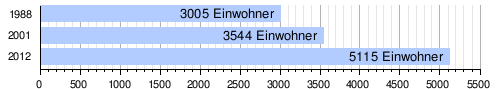
At the 2012 census, Malgorou had 5115 inhabitants who lived in 759 households. At the 2001 census, the population was 3,544 in 459 households, and at the 1988 census, the population was 3,005 in 452 households.
There is a cattle market in the village. The market day is Saturday. Malgorou is also a regionally important trading center for peanuts, grain and sugar cane. In addition to the location on national road 7, a network of paths around the village is particularly advantageous, as it enables the delivery of agricultural products from the area. Fruit is grown on the banks of the dry valley right by the village.
Personalities
- Yahaya Chaibou (* 1960), civil servant and politician
literature
- Mamadou Ouattara: A study of two toposequences of the dry valley systems of western Niger (West Africa) . Dissertation. Texas A&M University, College Station 1990.
Individual evidence
- ↑ Olivier Walther: Sons of the Soil and Conquerors Who Came on Foot: The Historical Evolution of a West African Border Region . In: African Studies Quarterly . Vol. 13, No. 1 & 2 , 2012, p. 77 ( sites.clas.ufl.edu [PDF; accessed November 4, 2018]).
- ↑ Répertoire National des localites (ReNaLoc). (RAR) Institut National de la Statistique de la République du Niger, July 2014, p. 168 , accessed on 7 August 2015 (French).
- ^ Répertoire National des Communes (RENACOM). (RAR file) (No longer available online.) Institut National de la Statistique, archived from the original on January 9, 2017 ; Retrieved November 8, 2010 (French). Info: The archive link was inserted automatically and has not yet been checked. Please check the original and archive link according to the instructions and then remove this notice.
- ↑ Recensement Général de la Population 1988: Répertoire National des Villages du Niger . Bureau Central de Recensement, Ministère du Plan, République du Niger, Niamey March 1991, p. 112 ( ceped.org [PDF; accessed January 31, 2018]). www.ceped.org ( Memento of the original dated January 31, 2018 in the Internet Archive ) Info: The archive link was inserted automatically and has not yet been checked. Please check the original and archive link according to the instructions and then remove this notice.
- ^ Mahamadou Saley, Yatta Paul Maurice Mohamed: Projet Régional d'Appui au Pastoralisme au Sahel (PRAPS). Etude diagnostique des Systèmes d'Information sur les marchés à bétail du Burkina Faso, du Mali, de la Mauritanie, du Niger, du Sénégal et du Tchad. Définitif report. (PDF) CILSS , November 2016, accessed on May 2, 2018 (French).
- ↑ Olivier Walther: Affaires de patrons. Villes et commerce transfrontalier au Sahel . Préface de Denis Retaillé. Peter Lang, Bern 2008, ISBN 978-3-03911-468-9 , pp. 202 and 236 .
Coordinates: 12 ° 10 ′ N , 3 ° 28 ′ E