Malmsbach
|
Malmsbach
Schwaig municipality near Nuremberg
Coordinates: 49 ° 28 ′ 22 ″ N , 11 ° 11 ′ 10 ″ E
|
|
|---|---|
| Height : | 313 m above sea level NHN |
| Residents : | 370 (1987) |
| Incorporation : | May 17, 1818 |
| Postal code : | 90571 |
| Area code : | 0911 |
|
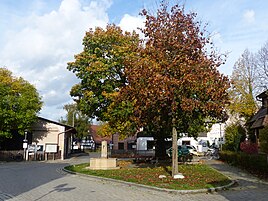
The center of Malmsbach
|
|
Malmsbach is a district of the municipality of Schwaig near Nuremberg in Middle Franconia ( district of Nürnberger Land ).
geography
The village is located about a kilometer west-northwest of the center of Schwaig, just northeast of the highway A3 . The transition to Schwaig is fluid, both localities have practically grown together today. In the north the Pegnitz runs in its valley.
history
The first written mention of Malmsbach goes back to a purchase contract from the year 1323, in which the place and the neighboring Behringersdorf passed to the burgrave of Nuremberg .
Malmsbach belonged to the extended rule of the empire ministerial dynasty of those von Gründlach , who built their ancestral castle Gründlach in Großgründlach in the 13th century . Malmsbach is mentioned for the first time in 1323 when Gottfried von Hohenlohe-Brauneck and his wife Margaretha, née von Gründlach, pledged their "Veste Malmspach" and the property in Behringersdorf for 240 pounds Heller to Burgrave Friedrich IV of Nuremberg, subject to redemption within three Years. In 1326 they had to sell not only Gründlach and its accessories, but also Hohenstadt, Malmsbach (“half aigen is and half a fief is from the rich”) and the realm of Behringersdorf to the burgrave. In 1329 he appointed Heinrich II “Vorcheimer von Almspach” as a feudal man . In 1342 the burgraves enfeoffed the "fish basins" from Fischbach near Nuremberg with the property. Allegedly, this branch of the family was also called "von Malmsbecken" (perhaps after the loss of Fischbach).
From 1365 various Nuremberg citizens followed as owners. They had to undertake to the council of the imperial city that the castle would only ever be sold to Nuremberg citizens and neither the lined moat nor the walls would be reinforced. The conditions are based on the fact that Malmsbach was a margravial fief, which prevented an “ opening ” of the seat in favor of Nuremberg in the event of war. During the First Margrave War, the people of Nuremberg plundered and destroyed the moated castle that had already been vacated by the occupation in their first campaign in 1449, because the lord of the castle Ulrich Rummel fought on the side of the margrave. After the war he was pardoned and in 1455 sold Malmsbach to Ludwig von Eyb, the council of Margrave Albrecht Achilles. In 1463 he sold the castle to Ludwig Pfinzing , who began with the reconstruction.
The Küfler followed in 1482, then the Peringsdorfer, Haller and Straub, 1553 the Imhoff , 1607 the Tucher , 1631 the Fürer , 1642 Spoonholz von Colberg , 1739 the landlord of Altenthann , until 1832. The castle was a multi-storey residential tower with a steep half-hipped roof and Dormitories on all sides; the Gothic chapel was built on the south-eastern corner tower of the curtain wall and contained a net vault and an altar from the 15th / 16th century. Century. In 1835, the new owner, the paper manufacturer Hahn from Röthenbach an der Pegnitz , had the estate, the castle, the chapel and the outer gatehouse removed in order to use the stones for a new building in Röthenbach. A lined trench with remains of the circular wall made of sandstone humpbacks (14th century), now partly the outer wall of the small houses built around the castle courtyard, and a gatehouse renovated in 1948, but heavily modified (sandstone block construction with hipped roof, protruding half-timbered upper floor and basket arched passage from the 16th century) have been preserved. /17th century). Furthermore, a small apartment building (single-storey sandstone block building with a saddle roof and half-timbered gable, dendrochronologically dated around 1710).
Due to the administrative reforms carried out in the Kingdom of Bavaria at the beginning of the 19th century , the place became part of the independent rural community of Schwaig with the second municipal edict.
traffic
Several municipal roads connect Malmsbach with Schwaig. In the south runs the St 2241 , which leads to the slip road Nürnberg-Mögeldorf (AS 87) on the A3.
Attractions
In addition to other architectural monuments, the one from the 14th / 15th centuries is in Malmsbach. Century castle .
See: List of architectural monuments in Malmsbach
literature
- Nuremberg country . Karl Pfeiffer's Buchdruckerei und Verlag, Hersbruck 1993. ISBN 3-9800386-5-3
Web links
- Malmsbach in the BayernAtlas (accessed on October 12, 2017)
- Malmsbach on a historical map (BayernAtlas Klassik) (accessed on October 12, 2017)
Individual evidence
- ↑ Official directory for Bavaria, territorial status: May 25, 1987, Munich, 1991
- ↑ Malmsbach in the location database of the Bayerische Landesbibliothek Online (accessed on October 12, 2017)
- ↑ Geographical location of Malmsbach (accessed on October 12, 2017)
- ↑ History of Malmsbach on the website of the municipality of Schwaig (accessed on October 12, 2017)
- ^ History based on: Giersch / Schlunk / von Haller: Castles and mansions in the Nuremberg countryside
- ↑ Political composition of the rural community Schwaig (accessed on October 12, 2017)


