Manyoni (district)
| Manyoni district | |
|---|---|
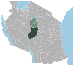
 Location of the Manyoni district in Tanzania |
|
| Basic data | |
| Country | Tanzania |
| region | Singida |
| surface | 28,934 km² |
| Residents | 296,763 (2012) |
| density | 10 inhabitants per km² |
| ISO 3166-2 | TZ-23 |
Coordinates: 5 ° 45 ′ S , 34 ° 50 ′ E
Manyoni is a district of the Tanzanian region Singida with the administrative center in the city of Manyoni . The district is bordered by the Ikungi district to the north, the Dodoma region to the east, the Iringa region to the southeast, the Mbeya region to the southwest and the Tabora region to the west .
geography
With an area of 28,934 square kilometers, Manyoni is the largest district in the region; in 2012 it had around 300,000 inhabitants. It is located on the central plateau of Tanzania at an altitude of mostly over 1000 meters above sea level. The largest rivers are the Kisigo and its right tributary the Myombe, both of which arise in Manyoni and drain into the Indian Ocean via the Ruaha and Rufiji . The climate in Manyoni is a local steppe climate, BSh according to the effective climate classification . Precipitation is low, it rains just over 100 millimeters in December, January, February and March. The dry season lasts from the end of May to the beginning of October, in July, August and September it usually does not rain at all. The warmest month is November with 23.3 degrees Celsius, the coolest is July with 18.7 degrees Celsius.
history
The district was established in 1958 as the first district in Tanzania.
Administrative division
Manyoni consists of a constituency (Council) and thirty parishes (Wards):
- Manyoni
- Solya
- Makuru
- Chikuyu
- Makanda
- Kintinku
- Mvumi
- Majiri
- Sasajila
- Idodyandols
- Chikola
- Heka
- Nkonko
- Sanza
- Isseke
- Rungwa
- Mgandu
- Itigi
- Ipande
- Sanjaranda
- Aghondi
- Mkwese
- Muhalala
- Saranda
- Makutopera
- Sasilo
- Mwamagembe
- Mitundu
- Kitaraka
- Itigi Majengo
population
The population of Manyoni District increased from 135,390 in 1988 to 204,482 in 2002 and to 296,763 in 2012. This means that the annual growth has increased from 2.9 to 3.7 percent, which doubles every 18.6 years corresponds. In 2012, almost half of those over five spoke Swahili, six percent spoke English and Swahili, and 44 percent were illiterate.
Facilities and services
- Education: 69 primary schools and 19 secondary schools are available for the education of young people.
- Health: The district has one hospital, two health centers and 29 pharmacies.
Economy and Infrastructure
|
 |
Attractions
- Rungwa Game Reserve: In the west, the district has a large portion of the 9,000 square kilometer Rungwa Game Reserve. The reserve is known for lions, leopards, buffalo, antelopes, zebras, hippos, crocodiles and bush pigs. Hunts and wildlife viewing are offered.
- Kizigo Game Reserve: The Kizigo Game Reserve is 4,000 square kilometers and was established in 1982. It offers game viewing and hunting in a varied landscape with thickets, miombo forests and river valleys.
religion
- Catholics: Manyoni belongs to the Singida diocese . In 2016 there were 10,227 Catholics in the district who were cared for by three priests.
Web links
Individual evidence
- ↑ Tanzania: Administrative Division (Regions and Districts) - Population Statistics, Charts and Map. Retrieved April 8, 2020 .
- ^ A b Tanzania Regional Profiles, 13 Singida Regional Profiles. (PDF) The United Republic of Tanzania, 2016, p. 16 , accessed April 8, 2020 .
- ^ Maps of the World. Russian Army Maps, S. Map 500k - xb36-2, Map 500k - xb36-4 , accessed April 8, 2020 (Russian).
- ↑ Manyoni climate: Average Temperature, weather by month, Manyoni weather averages - Climate-Data.org. Retrieved April 8, 2020 .
- ↑ Historia Yetu | Manyoni District Council. Retrieved August 28, 2020 .
- ↑ 2012 Population and Housing Census. (PDF) The United Republic of Tanzania, March 2013, p. 126 , accessed April 5, 2020 .
- Jump up ↑ Tanzania Regional Profiles, 13 Singida Regional Profiles. (PDF) The United Republic of Tanzania, 2016, p. 73 , accessed April 8, 2020 .
- ↑ a b Takwimu | Statistics. Retrieved April 8, 2020 .
- ↑ Kilimo | Agriculture. Retrieved April 8, 2020 (Swahili).
- Jump up ↑ Tanzania Regional Profiles, 13 Singida Regional Profiles. (PDF) The United Republic of Tanzania, 2016, pp. 132, 135 , accessed April 8, 2020 .
- ↑ Viwanda. Retrieved April 8, 2020 (Swahili).
- ^ Uranium Mining. (PDF) Rosa Luxemburg Foundation, April 2014, p. 8 , accessed on April 9, 2020 .
- ↑ Greg Roberts: Uranex dumps uranium for graphite. May 13, 2014, accessed April 9, 2020 .
- ↑ First test completed on Tanzania standard gauge line. In: International Railway Journal. July 8, 2019, accessed April 8, 2020 .
- ↑ a b Tanzania in Figures 2018. (PDF) National Bureau of Statistics, June 2019, p. 9 , accessed April 8, 2020 .
- ^ Rungwa Game Reserve. In: Tanzania Zalendo. Retrieved April 8, 2020 (American English).
- ↑ Tracks4Africa. Retrieved April 8, 2020 .
- ^ Catholic Diocese of Singida, Strategic Plan 2017-2021. (PDF) p. 60 , accessed on April 9, 2020 .

