
Marienplatz (Schwerin)

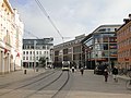
The Marienplatz in the Mecklenburg-Vorpommern state capital Schwerin is a historic, triangular course and a hub of urban transport. It is named after the sister Marie of the then Grand Duke Paul Friedrich .
Location and transport links
Marienplatz is located in Schwerin's old town 240 meters southwest of the Pfaffenteich . Wismarsche Straße , Helenenstraße, Schloßstraße (Schwerin) , Goethestraße and Lübecker Straße flow into Marienplatz, starting clockwise from the north .
As a local transport hub, Marienplatz is served by three of the four (lines 1, 2 and 4) trams and six of the 14 bus lines (lines 5, 7, 10, 12, 14, 19) of Schwerin local transport . On the railway line that runs 320 meters to the west, local passenger trains stop at the Schwerin-Mitte stop.
_in_1803.jpg)
Names
Historical names of the square, which was initially just the suburb , are Kuhhof , the square in front of the poor cemetery and the square in front of the mill gate . Later it was named after Marie zu Mecklenburg , who lived from 1803 to 1862 and was Duchess of Saxony-Altenburg by marriage since 1848 . On a map from 1939 you can find the name Adolf-Hitler-Platz . From 1950 to 1990 the inner city was called Leninplatz .
history


During archaeological investigations in connection with the construction of the Marienplatz-Galerie shopping center in the spring of 2009, in addition to everyday objects from the 18th and 19th centuries, a fountain made from a hollowed-out tree trunk with field stones placed on it, which dates back to the 1st century AD, was unexpectedly found . is dated. He points to a permanent German settlement at this time. Flint stones were also discovered dating from around 1000–600 BC. BC for the manufacture of tools such as axes and chisels.
In the 14th century, the district was outside the city walls in the suburb and west of the river ditch, which was the outflow of the mill pond (later Pfaffenteich) and another watercourse connected to this ditch. The old town could be reached via bridges through the Schmiedetor or the Mühlentor . During the Thirty Years War , the Great City Moat was built , which was filled in several times in the following centuries.
On the south side of the square there was once a poor house, to the north of it, on the site of today's Wurm-Passage, the poor cemetery. Also on the north side, at the site of today's Deutsche Bank branch, the savings institution, a forerunner of today's Sparkasse, later had an office. In the middle of the 19th century, the Brohn tobacco factory opened here, producing until 1903. After that, the Schultz furniture store and factory was located there. After the Second World War, tobacco products were produced again until around 1990.
The pharmacy on Marienplatz has existed on the west side since 1854, the facade of which was designed by Georg Adolf Demmler . The Konzerthaus Flora burned down in a large fire in 1909, and the entrepreneur Johannes Dürkop had the town halls built in its place in 1910 by the Lübeck architect Rudolf Wilcken , which soon became a social focal point with two halls and a series of club and assembly rooms City developed. After renovations at the beginning of the 1920s a. a. the architect Willy Taebel created a garage complex (under another hall), a car repair shop and a gas station in the late 1920s. Today's Sparkasse building on the southeast side was built by the architect Paul Fliether after a competition in 1937 .
Until after the end of the Second World War, the square was mainly characterized by hotels and restaurants. The small residence cinema was attached to the building of the Hotel Lübecker Hof , which was demolished after 1995 . The last of the half-timbered houses that once framed the square was demolished in 1984; previously it was used as a flower shop, control center for local transport and a waiting hall. The town halls were taken over by the Soviet allies and were henceforth the house of the officers until the withdrawal of the Red Army in 1993 . The building was in need of renovation and a dispute arose over the subsequent use of the building after the city halls had been cleared by the Red Army. On October 25, 1996, at the request of the city administration, the Schwerin city council decided to demolish the city halls on Marienplatz, and the dispute continued over the subsequent use and - also as areas for a shopping center (ECE), with the now decided and planned demolition of the listed city halls occurred, but was absolutely not absolutely necessary. The then state minister for building, regional development and the environment, Bärbel Kleedehn , decided on November 28, 1996 to - demolition of the town halls - dated January 25, 1997 this was implemented and subsequently the palace park center was subsequently used and restoration of some facades. There were structural interventions on the north side at the same time. From 1997, the self-so-called shopping, adventure and media center Der Wurm was built here, also with partial use of facades and other old buildings .
When the electric tram started operating in Schwerin on December 1, 1908, all three lines ran via Marienplatz, and of course there was a need to provide passengers with a shelter or waiting room at the important stop and transfer point to protect them from the weather deliver. On the already existing traffic island in the middle of the square, there used to be a small drinking hall, a kiosk of the Swiss house type with an underground bathroom with tiles on the walls. In the above-ground, closed waiting room, the arrival of the tram could easily be observed, and a public telephone was also set up. The building was erected in the summer of 1909 and put into operation on December 23, 1909. The construction costs amounted to 10,000 marks. In October 1926, the Schwerin city representatives decided to demolish the bus shelter that same year, to equip the square with a large clock and to redesign Marienplatz. To compensate for the demolition of the public facilities, the new toilet building was built on Totendamm, which was completed in the summer of 1927. It was designed by the architect and Schwerin city planner Andreas Hamann. The planned construction costs of the new toilet building were estimated at 18,000 RM, but exceeded by 1,800 RM because clinker brick was used instead of a plastered building. The Schwerin toilet building on Totendamm, which was once closed for a long time, was reopened in 2011 after extensive renovations. A major tram accident occurred on October 7, 1951, when a train coming from Wittenburger Berg derailed and sped unchecked into the building of the Schewe bakery. However, there was no personal injury. Since then, a lot has changed on the busy Marienplatz, kiosks and covered waiting stands were created and were later removed.
In 2008, local transport considered building a transfer facility in the middle of the square; a corresponding roofed facility existed as early as 1910, as can be seen on old postcards. At the same time, a uniform surface design for the track area was considered. The city saw a need for discussion, but pointed out that the new Marienplatz gallery had priority for the time being.
The latest project is the construction of the Marienplatz gallery on the east side of the square. Another shopping and business center was built here. Originally a hotel and a total of seven floors were planned. The demolition work on the Marienhöfe began in April 2008 and the completion date was set for March 2010. The last obstacle was an old and listed half-timbered storage facility in the inner courtyards, for which Otto Ebnet , at the time Minister for Transport, Building and Regional Development of the State of Mecklenburg-Western Pomerania, gave permission for demolition. A citizens' initiative led by monument conservator Sabine Bock protested against the demolition, but could not prevent it. In the meantime, consideration was given to rebuilding the building after it had been dismantled in Wolgast , where the old granary at the harbor fell victim to the flames in 2006 . However, this failed, among other things, due to the results of two reports that showed that the timber framing had been treated with toxic wood preservatives. The memory was demolished on September 11, 2008. On September 22nd, 2008 the construction of the Marienplatz Gallery was finally decided in a city council meeting. A move of the city library from Wismarschen Strasse to the new center was also under discussion. The old Perzina house , which has been used as a library since 1982, is in need of renovation. As a positive side effect, it was hoped that the number of users will increase. However, in December 2008 it was decided that the city library would not move.
The Marienplatz Gallery opened on May 12, 2011.
Shopping centers
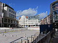
Marienplatz Gallery
The Marienplatz-Galerie was opened in May 2011 after a three-year construction period. It was realized by the Tenkhoff Properties Group in project partnership with Generali Deutschland Immobilien GmbH and AachenMünchener Versicherung AG. There are over 40 shops on four floors with a total of around 15,000 m² of retail space. The second basement floor serves as an underground car park with 148 parking spaces, the third floor offers around 2700 m² of office space.

Glass facade of the Marienplatz gallery
View of Marienplatz with the Marienplatz gallery on the right


Castle Park Center
The Schlossparkcenter was built between 1997 and 1998 for around 100 million DM and opened on September 23, 1998. The owner is City Center Immobilienfonds, a closed real estate fund of DB Real Estate, which belongs to the Deutsche Bank Group. The center is under the management of ECE Projektmanagement GmbH & Co. KG from Hamburg. It has 20,000 m² of retail space on three levels with around 120 shops.
The partly glass-roofed shopping center, which is integrated into the inner city development, has a maximum size of around 270 by 80 meters, 28 transverse and eight longitudinal axes and a continuous support structure made of reinforced concrete. The center has a three-level car park with over 1,000 parking spaces.

Glass facade of the palace park center

Restored facades of the palace park center and the pharmacy

Houses on the west side of the square (1990), today the location of the palace park center


Schwerin courtyards
This business center was opened as Der Wurm on May 7, 1998 after around 18 months of construction . Only part of the approximately 1.4 hectare area borders on Marienplatz in the south. It stretches north to Arsenalstrasse . The unusual name Wurm was derived from the Klöresgang inside the center, which stretched from Wismarschen Strasse into the block like a worm extension. The Schweriner Höfe have around 27,000 m² of usable space. The construction cost about 120 million DM. The construction of a parking garage, the entrance to which is on Arsenalstrasse, was only approved five years after the opening. In 2011, renovation work was carried out, including on the facades. At the same time the business center was renamed Schweriner Höfe .
Left Schlossparkcenter, in the middle Schweriner Höfe, right Marienplatz-Galerie

Corner building of the Schweriner Höfe (upper storey old building)

Schweriner Höfe by night


Individual evidence
- ↑ a b c d Heinz Eisträger: Between the poor cemetery and the poor house. The Marienplatz in Schwerin yesterday and today. in Mecklenburg-Magazin No. 35 (supplement to the Schweriner Volkszeitung), 29 August 2008
- ↑ B. Kasten and J.-U. Rost: Schwerin. History of the city. , Schwerin 2005, ISBN 3-935749-38-4 , p. 92
- ↑ a b With the leader to the Germanic tribes - Schweriner Volkszeitung, local page Schwerin, April 25, 2009
- ↑ 3000 years of city history on the large construction site - Schweriner Volkszeitung, May 9, 2009
- ↑ Image galleries of the construction phases of the worm ( page no longer available , search in web archives ) Info: The link was automatically marked as defective. Please check the link according to the instructions and then remove this notice. at altstadtfest-schwerin.de
- ↑ Never stand in the rain again. Local transport is planning a transfer facility at Marienplatz / Stadt: “Discussion needs” - Schweriner Volkszeitung , January 8, 2008
- ↑ Rental lists are filled. Plans for Schwerin's "Marienplatz-Galerie" are running at full steam. SVZ, February 18, 2008
- ↑ Yes to the Marienplatz Gallery. The demolition has started. The excavator reigns supreme at Marienhöfen / Opening of the center planned for March 2010 , SVZ, April 26, 2008
- ^ Minister approves storage demolition. Work on Marienplatz-Galerie still on schedule , SVZ, July 16, 2008
- ↑ The dispute over shopping center ended? Marienplatz investor wants to revise design / store perhaps after Wolgast. - SVZ, August 14, 2008
- ↑ Storage torn down , SVZ, September 12, 2008
- ↑ Yes to the Marienplatz Gallery. City representatives approved the development plan yesterday evening with a large majority, SVZ, 23 September 2008
- ↑ Are 150,000 books moving? Change of location to the new Marienplatz gallery is being checked - SVZ, 23 August 2008
- ↑ Library is not moving - SVZ, December 20, 2008
- ^ NDR television, Nordmagazin, May 12, 2011
- ↑ Marienplatz-Galerie Schwerin ( Memento of the original from April 19, 2012 in the Internet Archive ) Info: The archive link was inserted automatically and has not yet been checked. Please check the original and archive link according to the instructions and then remove this notice. at tenkhoff-properties.de
- ↑ a b Reference objects of the Lübcke surveying office, Schwerin
- ^ Castle Park Center Schwerin. ECE, accessed on March 3, 2019 .
- ↑ Measurement on the geodata viewer of the Office for Geoinformation, Surveying and Cadastre of Mecklenburg-Western Pomerania ( notes )
- ↑ 10 years of Der Wurm ( page no longer available , search in web archives ) Info: The link was automatically marked as defective. Please check the link according to the instructions and then remove this notice. at altstadtfest-schwerin.de (PDF file; 435 kB)
- ↑ Schweriner Volkszeitung: Wurm become Schweriner Höfe , May 14, 2011
Web links
Coordinates: 53 ° 37 ′ 43.1 ″ N , 11 ° 24 ′ 39 ″ E