
Old town (Schwerin)
|
Old town
City of Schwerin
Coordinates: 53 ° 37 ′ 42 " N , 11 ° 24 ′ 57" E
|
|
|---|---|
| Area : | 77 ha |
| Residents : | 3716 (Sep 30, 2017) |
| Population density : | 4,826 inhabitants / km² |
| Postal code : | 19053, 19055 |
 Location of the old town in Schwerin
|
|
The old town of Schwerin is a district and the historical core of the Mecklenburg-Western Pomerania state capital Schwerin .
location
_2.jpg)
The 77-hectare old town is located on the west bank of the southern part of Lake Schwerin, known as the Inner Lake , and borders the districts of Schelfstadt in the north, Werdervorstadt in the northeast, Ostorf in the south, Feldstadt in the southwest and Paulsstadt in the west. The area includes the Burgsee, which is a bay separated from the Schwerin Lake by the Schlossinsel and its bridges.
history


Main article: History of Schwerin
Records of a castle in a freshwater lake exist as early as 965, which historians attribute to Schwerin. In the face of the overpowering approaching troops of Henry the Lion , the Obotrite prince Niklot burned the castle down in 1160. After Heinrich's victory over Niklot, the city of Schwerin was founded and the castle was rebuilt. The first cathedral is donated around 1171. The city was initially secured by a wooden wall. The mill pond (later: Pfaffenteich ), which was created by the damming of the Aubach since 1284 , once extended to the south of today's Marienplatz . The city was accessible via the Grafenmühle dam located there .
The name of the Tappenhagen street was first mentioned in 1403, but it did not belong to the city of Schwerin until the end of the 15th century. The expression "-hagen" can be traced back to the Germanic word "hago" and denotes a fenced area. Tapping, on the other hand, either stands for the Low German word "Zapfen" or goes back to a personal name. Today only a narrow path on the - Großer Moor - is evidence of the beginning of the former course.
The wooden city fortifications were not replaced by a wall until the 14th century, which did not enclose the shelves north of Schwerin that were developing parallel to the old town . Later a new entrance was created through the Schmiedetor and the Schmiedestrasse . Until the end of the 18th century, the city fortifications were further developed using the water resources and gradually torn down again as the residential buildings expanded. Remains of the city wall have been preserved in Burgstrasse to this day.
In the fires in 1531, 1558 and 1561, large parts of the old town's buildings were destroyed. With the exception of the Schwerin Cathedral , the cathedral courtyard and some parts of the castle, no buildings have survived that were built before the 17th century. The old town is shaped by the historicism of the 19th century. When the ducal residence was relocated from Ludwigslust to Schwerin in 1837, both the economy and construction activity revived. Under the influence of Georg Adolph Demmler , appointed court architect in 1841 , representative buildings and the redesigned Schwerin Palace were erected.
The Pushkin-Str. - Großer Moor - Bader Str. - as well as the Salz Str. Were once referred to as the Schwerin old town quarter. In the corner house of Pushkin, - to Salz Str., There was a confectionery shop "Schogette" which, like another one in 1977, was demolished - a lot of victims were blown up. Since 1968, new residential buildings have been built in prefabricated construction on the Great Moor in the old town, after old, neglected buildings there were demolished and piled up on the Burgsee. The monotonous appearance of the prefabricated buildings was only loosened up by maintaining the historical street layout, partially clinker facing the facades and the beveling of the roofs. Only in the 1980s were some half-timbered buildings renovated.
Extensive renovations to the castle and historic buildings in the old town only took place after years of decline after the political change . With this, inner-city shopping centers and passages such as the Burgseegalerie , the Wurm and the Schlossparkcenter were created .
Sights and culture
- Schwerin Castle , today the seat of the Mecklenburg-Western Pomerania state parliament
- Schwerin Cathedral
- Mecklenburg State Theater Schwerin
- State Museum Schwerin
- Town hall and the market
- Stables
- Old palace
- College building I as the seat of the State Chancellery
- Demmler House
- House of Culture (HDK)
- Cafe Prague

Schwerin Castle

Remains of the city wall
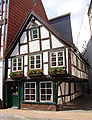
House of Zettler from 1698

Great Moor (2007)

Castle renovation (1990)
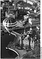
Hot air balloon ride over the castle (1990)

House Zettler (1955)
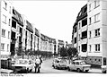
Great Moor (1988)


_cleaned.jpg)


Economy, transport, infrastructure
The central transfer point for local transport in the city is located at Marienplatz. Three of the four tram and several bus lines meet here. The main station is located in the neighboring Paulsstadt district, the Schwerin Mitte stop, which was established after 1990, is on the border with Feldstadt.
Parts of the old town are designated as a pedestrian zone. Significant streets are: Arsenalstrasse , Buschstrasse , Goethestrasse , Graf-Schack-Allee , Mecklenburgstrasse , Puschkinstrasse , Schlachterstrasse , Schloßstrasse , Schmiedestrasse , Schusterstrasse , Werderstrasse and Wismarsche Strasse
literature
- Sabine Bock : Schwerin - the old town. Urban planning and house stock in the 20th century (contributions to the history of architecture and monument preservation in Mecklenburg and Western Pomerania, vol. 1) . Thomas Helms Verlag, Schwerin 1996, ISBN 3-931185-08-7 .
- Sabine Bock , Rudolf Conrades (ed.): Georg Adolph Demmler. Some notes from my life 1804–1886. Thomas Helms Verlag, Schwerin 2004, ISBN 3-935749-45-7 .
- Bernd Kasten, Jens-Uwe Rost: Schwerin. History of the city . Thomas Helms Verlag, Schwerin 2005, ISBN 3-935749-38-4 .
- Schweriner Express: August 22, 2015 The Schwerin old town quarter and the “Schogette” confectionery shop after the demolition in 1977 page 02 express-medienhaus.-nord.de.
Web links
- History and photos of Schwerin's old town
- Submission of a draft of a monument area ordinance with "Annex Plan Altstadt"; There location of the listed buildings (before the area was demolished in 2008 at Marienplatz)