Must
Location of Mueß in Schwerin |

Mueß is a district of Schwerin , the capital of Mecklenburg-Western Pomerania , with 956 residents with main residence and an area of 327 hectares.
location
Mueß is located in the southeast of the Schwerin urban area on the south bank of the Schweriner See and borders in the west on the districts of Zippendorf and Mueßer Holz and in the south and east on the municipality of Raben Steinfeld, which belongs to the Ludwigslust-Parchim district . The southern part of Lake Schwerin, known as the Inner Lake, forms the Mueßer Bay between the Ziptehorn, which belongs to Zippendorf, and the Reppin peninsula, which is located in Mueßer and is forested on the lake side . The sturgeon, the natural outflow of Lake Schwerin, developed as a navigable canal, forms the eastern border of Mueß; to the west is the Mueßer Holz forest area of the district of the same name. The district is criss-crossed by some drainage ditches, such as the Mueßer drainage ditch in the west, which flows into the lake, and other ditches in the east, which mostly drain into the Stör. The Niederfeldische Wiese takes up a large part of the landside area of the district .
The islands Rabbitwerder and Ziegelwerder in Lake Schwerin are a must .
history
Georg Christian Friedrich Lisch already assumed that the Reppin peninsula was inhabited by Slavs and that there was a Slavic castle wall here. This view has not yet been fully proven, but it is covered by the location of the ramparts and by archaeological finds. In the vicinity there are also former clay pits and waste from brick production. Even the name can be derived from the Slavic Repin and means something like beet country or beet village, which suggests an agricultural use at that time.
The first written mention of the original fishing and farming village of Mueß dates back to 1304. At the time, the village was owned by the knight of Hazekop. At the end of the 15th century it was acquired by the Mecklenburg duke. After the Thirty Years War , in which the village was destroyed and fell desolate , a new settlement took place. In 1775 a hiking trail was created between Zippendorf and Mueß especially for Princess Charlotta, which was briefly protected from unauthorized use by a barrier.
On October 1, 1936, Mueß was incorporated into Schwerin along with other villages.
Attractions
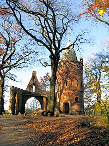
In 1907, an artificial castle ruin, the so-called Reppiner Burg , was built on the Reppin peninsula on a hill on the shore of Lake Schwerin. The castle tower can be climbed. From here you have a view of the Schwerin lake including the islands of Rabbitwerder and Ziegelwerder as well as the silhouette of the Schwerin city center. In front of the castle ruins there is a memorial stone for Friedrich Wilhelm, a son of Grand Duke Friedrich Franz II.
Since 1970 an agricultural history museum has been built with the Schwerin-Mueß open-air museum. It includes, among other things, partly thatched , preserved and restored buildings in the village center, a forge relocated from Stove ( Carlow municipality ) in 1975 , a Low German hall house , a Mecklenburg hall barn, a Büdnerei and the former village school. The open-air museum provides information about the way of life of the Mecklenburg rural population from the 17th century to the beginning of the 20th century.
Transport links
The federal highway 321 runs through the district, which connects Schwerin with the Schwerin-Ost junction of the federal highway 14 and with the cities of Crivitz and Parchim . The road in Mueß is only partially four-lane, a complete four-lane expansion is under construction. Mueß is integrated into the Schwerin local transport network through bus connections .
Web links
Individual evidence
- ↑ Schwerin in figures on schwerin.de, as of June 30, 2018, accessed on December 4, 2018.
- ↑ a b c Residence information Schwerin ( Memento of the original dated November 4, 2008 in the Internet Archive ) Info: The archive link has been inserted automatically and has not yet been checked. Please check the original and archive link according to the instructions and then remove this notice.
- ↑ a b Georg Dehio : Handbook of German Art Monuments. Mecklenburg-Western Pomerania. Deutscher Kunstverlag, Munich / Berlin 2000, ISBN 3-422-03081-6 .
- ↑ Bernd Kasten , Jens-Uwe Rost: Schwerin. History of the city. Helms, Schwerin 2005, ISBN 3-935749-38-4 , p. 112.
Coordinates: 53 ° 35 ' N , 11 ° 29' E


