
Paulsstadt
|
Paulsstadt
City of Schwerin
Coordinates: 53 ° 37 ′ 58 ″ N , 11 ° 24 ′ 15 ″ E
|
||
|---|---|---|
| Area : | 96 ha | |
| Residents : | 8964 (Sep. 30, 2017) | |
| Population density : | 9,338 inhabitants / km² | |
| Postal code : | 19053 | |
Location of Paulsstadt in Schwerin |
||


The Paulsstadt is a district in the district 2 of the Mecklenburg-Vorpommern state capital Schwerin .
Location, residents
The 96 hectare Paulsstadt is located in the area between Obotritenring , Alexandrinenstraße (formerly Karl-Marx-Straße), Arsenalstraße and Eisenbahntrasse, west of Schwerin's old town , the historic core of Schwerin, and borders to the east with the Pfaffenteich and the districts of Lewenberg in the north , Schelfstadt in the east, Feldstadt in the south and the Weststadt in the west.
In 2012, 8,726 people lived in the district.
history
In 1837, when Grand Duke Paul Friedrich took office, he moved the ducal court from Ludwigslust to Schwerin. The Grand Duke formed a commission to plan the necessary expansion of the city to the south and west. State master builder Georg Demmler presented a study according to which the city should be expanded to the west. Then the expansion of the Schwerin Paulsstadt began. It takes its name after the sovereign Paul Friedrich.
In 1838/39 a dam was built on the south and west banks of the Pfaffenteich. The Alexandrinenstraße was filled in and paved. From 1839 onwards, buildings were built on Wismarschen Strasse and Arsenalstrasse with houses in the classicist style.
The arsenal at Pfaffenteich , a military building, was built by Demmler until 1844. In 1841 a river ditch was vaulted, thereby improving the connection between the old town and Paulsstadt. A new, turf-covered rampart with gatehouses ran from Ostorfer See past the cemetery over Vossstrasse to Moltkeplatz and further behind the train station over the shelf to Heidensee . In 1863 internal tariffs were abolished and the wall lost its function.
In 1847 the first station building and the Hagenow Land – Schwerin line were built as a connection to the Berlin-Hamburg line . In 1890, today's station building of Schwerin Central Station was built according to plans by building officer Carl Jacobi, a building in the style of the early days .
The ornamental fountain Rescue in Distress from 1910 with bronze sculptures by Hugo Berwald has been on the station forecourt, today Marianne-Grunthal- Platz . Local transport facilities are concentrated on the square. Four uniform residential buildings were built in 1847 according to Demmler's plans. The InterCityHotel was built in 1972 as the Hotel Stadt Schwerin . Since 2005, a tunnel that previously only provided access to the platforms has also opened up the rear side of the station with the building of the former Grand Ducal General Railway Directorate of the Friedrich-Franz Railway (later Reichsbahndirektion Schwerin ). An older pedestrian tunnel that did not provide access to the platforms and whose portals are still there was closed in 2005.
Due to the increase in the population at the end of the 1850s, the Paulskirche was also built between 1863 and 1869 according to plans by building officer Theodor Krüger . As a neo-Gothic church, it was placed on an extended hill for urban planning purposes.
From 1883 to 1885, the neo-Gothic secondary school was built according to plans by senior building officer Georg Daniel and executed by the state master builders Zöllner and Raspe. The later brick school of peace is 44.33 meters long and up to 24.5 meters high.
Since 1901 there is the Hotel Niederlandeischer Hof on Wilhelmstraße (today street Zum Bahnhof ), which moved in 1921 into a converted house at Alexandrinenstraße 12/13. In 1916 the judicial building and the judicial prison designed by the Ministerialbaurat Paul Ehmig were inaugurated on today's Demmlerplatz. The remand prison was used until 1989. The use of the representative judicial building changed several times: After the war, the Soviet secret service NKVD took over the building in 1945 . The Soviet Military Tribunal (SMT) also met here. In 1954 the building came to the Ministry of State Security (MfS). After the fall of the Wall , the building was used by the Ministry of Justice from 1990 to 1993. The court building is then the location of the Schwerin Regional Court and the Schwerin District Court .
Paulsstadt was included in the urban development programs from 2004 . On the basis of the urban development concept Eastern Paulsstadt , measures to improve and upgrade public space and to reduce the vacancy rate of buildings are to be implemented. In 2006 the redevelopment area Paulsstadt was decided for the western parts of the district .

Paulsstadt, Arsenal and Paulskirche

Central Station

Emergency well at the main train station

Central station from 1847

Arsenal at the Pfaffenteich
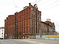
Storage

.JPG)


politics
Paulsstadt is represented in the local advisory board of Altstadt, Feldstadt, Paulsstadt, Lewenberg, which has its office in the town hall at Am Packhof 2–6. Of the nine advisory board members, two each are from the CDU parliamentary group, the SPD parliamentary group and the left parliamentary group and one each from the Bündnis 90 / Greens parliamentary group, the ZG AfD parliamentary group and the independent citizens group .
Sights and infrastructure

Buildings, monuments
- The arsenal at Pfaffenteich from 1844, designed by Demmler, has been the seat of the Interior Ministry since 1990.
- The Paulskirche dates from 1869.
- The main railway station in from 1889-90 was built according to plans by Carl Jacobi.
- The building of the former Grand Ducal General Railway Direction (later Reichsbahndirektion Schwerin ) from the Wilhelminian era stands at the rear of the station.
- The courthouse, Demmlerplatz 1/2, was built from 1914 to 1916 according to plans by Paul Ehmig .
- The town hall of the Schwerin city administration, Am Packhof, was built in the 1990s.
- The grand ducal office from 1845 based on plans by Ludwig Bartning
- The old cemetery with the Demmlerkapelle, Obotritenring 247, is located on the western border of the district.
- The cemetery of the victims of fascism is a memorial cemetery and a testimony to how the Nazi past was dealt with in the GDR.
- The Paulsstadt Speicher on Dr.-Külz-Strasse
- The Broken is a sculpture by Thomas Lehnigk that has been on the Mayor's Bathing Square since 2009. The steel ball symbolizes the earth, which should be handled with care.
schools
- The Friedensschule is a primary school on Friedensstrasse.
- The Fritz Reuter School is a primary school on Vossstrasse.
- The Erich-Weinert-Schule is a regional school on Rudolf-Breitscheid-Straße.
- The vocational school for business and administration is at Obotritenring 50.
Kindergartens
- Schwerin maintains the Pumuckl day care center , Breitscheid-Str. 15 a
traffic
The Schwerin tram lines run through Paulsstadt
- 1 : Clinics - Central Station - Marienplatz - Hegelstrasse
- 2 : Lankow - settlement - Freedom Square - Marienplatz - Hegelstrasse
- 4 : Freedom Square - Marienplatz - Neu Pampow
Bus lines 5, 7, 8, 10, 11, 12 and 19 reach Paulsstadt. The station forecourt and the Platz der Freiheit are important transfer stations in Paulsstadt.
The main train station is also located in Paulsstadt .
The Obotritenring is the most important western bypass of the Paulsstadt with the connections of the Knaudtstraße / Werderstraße in the east (Schelfstadt) and the federal highway 104 to the north (Werdervorstadt), the Lübecker Straße to the northwest (Weststadt, Lankow), the Wittenburger Straße to the west (Weststadt , Neumühle), the Rogahner Straße to the southwest (Görries, Krebsförden) and the street Ostorfer Ufer to the south (Feldstadt, Großer Dreesch). Other significant streets with Wikipedia articles are: Alexandrinenstraße , Arsenalstraße , Wismarsche Straße
The small ferry Weever on the Pfaffenteich leads from Paulsstadt to Schelfstadt and is a summer tourist offer.
literature
- Manfred Kriek: Zuarin bis Schwerin - A city chronicle from 1160 to 1990. Birknerverlag, Hamburg 1990, ISBN 3-923543-91-3 .
Web links
Individual evidence
- ^ Local Advisory Board Old Town, Feldstadt, Paulsstadt, Lewenberg , accessed on March 12, 2016