
Wall skull

The ruin Mauerschädel is the ruin of a fortified church in the Rhön , located in the Rhön-Grabfeld district .
Geographical location
The church ruin Mauerschädel is located in a gentle valley directly next to the village of Filke, a district of the Willmars community. The ruin is right on the border between Thuringia and Bavaria .
history
Around the year 770 there is the first written mention of a place "Biscofestat" ( episcopal city? - with supposedly over 300 bakers), to which the church ruin Mauerschädel should originally have belonged. A certain aristocrat donated these estates to the Fulda monastery . In this context there were two other communities that disappeared, “Solzach” and “Hoitino”.

The church is believed to be built around the year 1000. The village of Bischofs is said to have still existed in 1334 - a hundred years later it is described as "desert". The forecast for intended incident Huns destroyed the village bishop and a massacre have caused among Christians. In 1458 the place Filke is mentioned for the first time - "To the bishop in the Filken".
Investigations in 1903 are said to have established that the ruins were not - as assumed - the remains of a women's monastery, but the church of the former bishop's place. In the ruin, the gaden of the church can still be seen today .
The inner-German border originally ran between the chancel and the nave. In the 1970s the entire ruin was assigned to the Free State of Bavaria and thus to the Federal Republic of Germany by the German-German border commission.
photos

Remains of the church tower and church walls
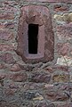
Window on the tower
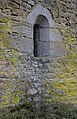

Remnants of the Gaden

View from the church tower to Filke


literature
- Franz Georg Benkert : The ruins of the bishop, Würzburg 1850. ( digitized version )
- Alfons Maria Borst : Filke: Der Mauerschedel , Mellrichstadt "Heimatblätter" April 1932.
- Reinhold Albert : The middle litter Bischofswald in Thuringia . Homeland yearbook of the district of Rhön-Grabfeld 2016, p. 188 ff, Mellrichstadt 2015.
- Ludwig Wucke : Legends of the central Werra, the adjacent slopes of the Thuringian Forest, the front and the high Rhön, as well as from the area of the Franconian Saale . Eisenach 1891.
Web links
Individual evidence
- ↑ Reiner Cornelius: From the Rhön to the Thuringian Forest. From the death strip to the lifeline. Auwel-Verlag, Niederaula, 2011, ISBN 978-3-9812981-5-4 , p. 71.


Castles: Altenstein Castle (Untermarschalk'scher Hof) | Old Trappstadt Castle | Brennhausen moated castle | Eichenhausen Castle | Gebsattelsches Castle | Hanstein Castle | Hanstein Castle | Holzberg Hunting Lodge | Irmelshausen moated castle | Kleinbardorf Castle | Kleineibstadt Castle (exited) | Löwenhain Castle | Mellrichstatt Castle (exited) | New Trappstadt Castle | Neuhaus Castle | Neustädles Castle | Obereßfeld Castle | Rödelmaier Castle | Rossrieth Castle | Sternberg Castle | Sulzfeld Castle | Unsleben moated castle | Untereßfeld Castle (sold) | Völkershausen Castle | Waltershausen Castle | Wolzog Castle
Castles and ruins: Altenbrenda Castle (dismissed) | Blankenberg Castle (exited) | Hildenburg castle ruins | Lichtenburg castle ruins | Osterburg castle ruins | Salzburg Castle | Steineck Castle (exited) | Wallbach castle ruins | Wildberg castle ruins
Fortifications: Königshofen Fortress
Tower hill castles (all gone): Tower hill Altenburg | Double tower hill Oberweißbrunn | Turmhügel Rappershausen (Turmhügel Burgkeller) | Wollbach Tower Hill
Manor houses: Yellow Castle (Rosenauischer Hof) | Heßbergsches Schlösschen | Höchheim Castle | Huflar Castle | Optical lock
Castle stables (lost, unknown castles): Section fortification Altenburg | Ringwall Altenburg | Burgstall Blankenberg | Burgstall Borstadel | Burgstall Frickenhausen | Gangolfsberg ramparts (Werinfriedesburg) | Ringwall Heidelberg | Burgstall Heustreu | Königsburg ramparts | Königshofen Fortress | Burgstall Lure | Fortification near Rappershausen | Burgstall Rothausen | Ringwall Schwedenschanze | Burgstall Simonides | Burgstall Völlburg
Fortified churches: Fortified church wall skull | Ostheim Fortified Church | Sulzfeld fortified church | Fortified church Trappstadt (St. Burkard)
Waiting towers : thick tower | Gallows Tower | Ostheimer Warte | Königsburg (Nordheim) (exited) | Suhlesturm | Stockheimer Warte | White Tower | Wollbach watch tower
Coordinates: 50 ° 31 '8 " N , 10 ° 13' 36" E