Mýto u Tachova
| Mýto | ||||
|---|---|---|---|---|
|
||||
| Basic data | ||||
| State : |
|
|||
| Region : | Plzeňský kraj | |||
| District : | Tachov | |||
| Municipality : | Tachov | |||
| Area : | 345,445 ha | |||
| Geographic location : | 49 ° 48 ' N , 12 ° 35' E | |||
| Residents : | 56 (March 1, 2001) | |||
| Postal code : | 347 01 | |||
| License plate : | P | |||
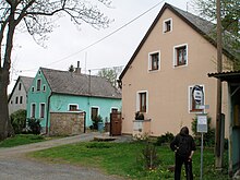
Mýto (German Mauthdorf ) is a district of the city of Tachov in the Czech Republic . It is located about three kilometers west of the urban area of Tachov in the Upper Palatinate Forest (Český les). To the southwest of the village, in the area of the former municipality of Lučina (Sorghof), the Mies is dammed up in the Lučina dam .
The historic " Golden Street ", an old trade route between Nuremberg and Prague , leads past Mýto . The course of this historic road can still be followed in the west of the Czech Republic . Coming from the town of Bärnau in Bavaria, the route runs from the German-Czech border via Vorder-Paulusbrunn to Obora, past the Lučina dam , past Milíře (at the Brandner Hegerhaus ), via Mýto (Mauthdorf) to the former castle of the princes of Windisch- Grätz to Tachov (Tachau).
history
In the 16th century the place is called as the village of the Tachau rule ; the tax roll mentions 2 farmers, 3 chalupners and 15 gardeners (small farmers) before the Thirty Years War . The village is certainly older. The Mauthdorfer Mühle was built in the 18th century. The number of houses rose to 29 by 1788, and before the Second World War the number of house numbers rose to number 54.
The pastoral care was incumbent on the deanery church in Tachau . A school building was built in 1889. Until 1875, the later municipality of Sorghof also belonged to the municipality .
The number of inhabitants was 236 in 1930 and 220 in 1939, of which 24 farmers and 17 " cottagers " as well as three inns were noted, including the inns of Johann Brunner (No. 15) and Josef Vrana at the "Waffenhammer" “, A popular destination for the Tachau population.
There are interesting types of rock at the site, and limestone quarries are mentioned as early as the 16th century. The gravel quarry at the foot of the Vogelsberg was operated by the Tachau district until 1945 . A granite quarry was also in operation on site.
After the Munich Agreement , the place was added to the German Empire and until 1945 belonged to the Tachau district .
The Second World War ended for the population with the occupation of the village by American troops. In the autumn of 1946, all of the forcibly evacuated Germans had left the village of Mauthdorf. In 1991 the place had 21 inhabitants. In 2001 the village consisted of 13 houses in which 56 people lived.
The village today has only about half of the previous development. In addition to the memorial on the village square, stone carvings by the sculptor Georg Böhm can be found in the local area .
literature
- Josef Schnabl (arrangement): Home atlas of the former political district Tachau-Pfraumberg. (Based on the collection of rescued maps, plans, photos and records from the local supervisors and residents of the former communities) . Local history working group of the Tachauer, Geretsried 1973.
- Zdeněk Procházka : Tachovsko = Tachau District (= Český les. Historicko-turistický průvodce. = Historical-tourist guide. 2). Nakladatelství Českého Lesa, Domažlice 1994, ISBN 80-901122-2-6 .
Web links
- Information about the place (CZ)
- Stone carving in Myto
- Map 1: 50000 ( Memento from September 25, 2006 in the Internet Archive ) (Czech)
- Church register of the former parish


