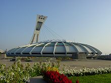
Mercier-Hochelaga-Maisonneuve
| Mercier-Hochelaga-Maisonneuve | |
|---|---|

|
|
| city | Montreal |
| surface | 25.4 km² |
| Residents | 131,483 (2011) |
| native language |
French : 78.6% English : 3.4% Other: 18.0% |
| Community number | REM22 |
| Website | Arrondissement |
Mercier-Hochelaga-Maisonneuve is one of 19 arrondissements in the city of Montreal in the Canadian province of Québec . In 2011 the 13.7 km² district had 131,483 inhabitants.
geography
Mercier-Hochelaga-Maisonneuve is located in the northeast of the Île de Montréal on the banks of the St. Lawrence River . The district is made up of the districts Hochelaga-Maisonneuve in the south, Mercier-Ouest in the middle and Mercier-Est (also called Tétreaultville) in the north. The central part in particular is characterized by industrial zones and the facilities of the Montreal port .
Neighboring arrondissements of the city of Montreal are Anjou in the west, Saint-Léonard and Rosemont-La Petite-Patrie in the west, Le Plateau-Mont-Royal in the southwest and Ville-Marie in the south. The district borders in the north on the independent municipality of Montréal-Est .
history
The name of the district recalls Honoré Mercier (Prime Minister of the Province of Québec from 1897 to 1901), the Indian village of Hochelaga ( discovered by Jacques Cartier in 1535 ) and Paul Chomedey de Maisonneuve , who founded the city of Montreal in 1642.
The area has been populated since the early 18th century. The parish of Saint-François-d'Assise-de-la-Longue-Pointe, established in 1719, is one of the oldest on the island. In 1845, the self-governing community Longue-Pointe was founded, which was gradually reduced in size as a result of increasing urbanization. Hochelaga, which is closest to the city center, was an independent municipality from 1875. Industrialization provided a surge in growth, which is why it received city status in 1883. But in the same year, Hochelaga was the first municipality to be merged with Montreal. The reason for this was the lack of funds for the provision of the necessary infrastructure.
Some landowners did not agree with this merger, bought a part of Hochelaga that had remained rural and in 1883 established the municipality of Maisonneuve. Longue-pointe continued to shrink. Beaurivage-de-la-Longue-Pointe was founded in 1898 and finally Tétreaultville in 1907. The latter only existed for three years, also in 1910 Beaurivage and Longue-Pointe were incorporated into Montreal. The conclusion in 1918 was the incorporation of Maisonneuve.
The district is still characterized by working-class neighborhoods. Numerous company closings in the 1980s lead to a marked increase in unemployment, poverty and crime. Although a revitalization process began after 2000 , the district continues to suffer from a bad reputation.
population
According to the 2011 census, Mercier-Hochelaga-Maisonneuve counted 131,483 inhabitants, which corresponds to a population density of 5176 inhabitants / km². Of the respondents, 78.6% said French and 3.4% said English as their mother tongue. Other important languages include Spanish (3.6%), Arabic (2.6%), Italian (2.2%), Chinese (1.7%) and Portuguese (1.3%). This means that this district has the highest percentage of French speakers.
Attractions
- Olympic Park with Olympic Stadium and Stade Saputo
- Château Dufresne
- Bellerive promenade
- Marché Maisonneuve
- Caserne Letourneux
- Le Très-Saint-Nom-de-Jésus church
- Nativité-de-la-Sainte-Vierge-d'Hochelaga church
Web links
Individual evidence
- ^ Longue point. Commission de toponymie Québec, accessed September 2, 2011 (French).
- ^ Bref historique du Quartier Hochelaga. Musée Marc-Aurèle Fortin, accessed on September 2, 2011 (French).
- ↑ Maisonneuve. Commission de toponymie Québec, accessed September 2, 2011 (French).
- ↑ Beaurivage-de-la-Longue-Pointe. Commission de toponymie Québec, accessed September 2, 2011 (French).
- ↑ Annuaire statistique de l'agglomération de Montréal, recensement de 2011. (PDF, 728 kB) City Council of Montreal, Statistics Canada, 2011, accessed on February 25, 2014 (French, Statistical Yearbook of the Agglomeration of Montreal 2011).
Coordinates: 45 ° 34'7 " N , 73 ° 32'2" W.


