Mercurole
| Mercurole | ||
|---|---|---|
|
|
||
| local community | Mercury Veaunes | |
| region | Auvergne-Rhône-Alpes | |
| Department | Drôme | |
| Arrondissement | Valence | |
| Coordinates | 45 ° 5 ' N , 4 ° 54' E | |
| Post Code | 26600 | |
| Former INSEE code | 26179 | |
| Incorporation | January 1, 2016 | |
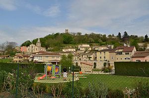
 View of Mercurol |
||
Mercurol is a former French commune with last 2,245 inhabitants (2013) in the department of Drôme in the region Auvergne Rhône-Alpes . It belonged to the arrondissement of Valence and the canton of Tain-l'Hermitage .
With effect from January 1, 2016, it was merged with the former municipality of Veaunes and merged to form the Commune nouvelle Mercurol-Veaunes .
geography
Mercurol is located about 16 kilometers north of Valence on the Rhone River in the Crozes-Hermitage wine-growing region . Mercurol is surrounded by the neighboring towns of Chantemerle-les-Blés in the north, Chavannes in the northeast, Veaunes in the east, Chanos-Curson in the east and south-east, La Roche-de-Glun in the south and south-west, Tournon-sur-Rhône in the west and south-west , Tain-l'Hermitage in the west and Larnage in the northwest.
Autoroute A7 and Route nationale 7 run through the area .
history
The old Roman road, Via Agrippa , ran through the former municipality .
Population development
| 1962 | 1968 | 1975 | 1982 | 1990 | 1999 | 2006 | 2013 |
|---|---|---|---|---|---|---|---|
| 837 | 907 | 1.011 | 1.313 | 1,643 | 1,670 | 2,019 | 2,245 |
| Source: Cassini and INSEE | |||||||
Attractions
- Sainte-Anne church from the 16th century, restored in the 19th century
- Saint-Pierre chapel in Marnas, mentioned in 1015, restored from 2000 to 2008
- Mercurol castle ruins with donjon, probably built in the 11th century
- Blanchelaine fortified house, built at the end of the 15th century

