
Mesochori (Karpathos)
|
Local community Mesochori Τοπική Κοινότητα Μεσοχωρίου (Μεσοχώρι) |
|||
|---|---|---|---|
|
|||
| Basic data | |||
| Country |
|
||
| region | South Aegean | ||
| Regional district | Karpathos and Kasos | ||
| local community | Karpathos | ||
| Parish | Karpathos | ||
| Geographic coordinates | 35 ° 38 ′ N , 27 ° 7 ′ E | ||
| Height above d. M. |
110 m (average) |
||
| surface | 34,800 km² | ||
| Residents | 371 (2011) | ||
| LAU-1 code no. | 62010106 | ||
| Post Code | 85700 | ||
| Telephone code | 22450-2 | ||

Mesochori ( Greek Μεσοχώρι ( n. Sg. ), Middle village ') is a village in the middle of the west coast of the Greek island of Karpathos . Together with the further south scattered settlement Lefkos and the coastal settlement Kato Lefkos the village provides the same local community (Τοπική Κοινότητα Μεσοχωρίου Topiki Kinotita Mesochoriou ) in Karpathos district (Δημοτική Ενότητα Καρπάθου Dimotiki Enotita Karpathou ) of the municipality of Karpathos .
location

The village is located on a rock plateau facing northwest on the northwestern foothills of Profitis Ilias, almost 200 meters above the west coast. Until a road was built in 1960, the village could only be reached on foot or by sea via the small landing stage Káfkalo (Όρμος Καύκαλου). Mesochori can be reached via an approximately 2 kilometer cul-de-sac from the western main road. Because of its winding and narrow streets, Mesochori is car-free, cars only have access to a parking lot above the village. The settlements of Lefkos and Kato Lefkos, which are part of the local community Mesochori, are located about 5 kilometers to the southwest. The village of Spoa is about 3 kilometers northeast.
The area of the local community Mesochori (Τοπική Κοινότητα Μεσοχωρίου) extends over an area of 34,800 square kilometers along the west coast. In the north it borders the municipality of Olymbos , in the east the local communities Spoa, Volada and Pyles border from north to south .
administration
Shortly after the annexation of the Dodecanese to Greece, Mesochori received the status of a rural community (Κοινότητα Μεσοχωρίου Kinotita Mesochoriou ). The two southern coastal towns of Lefkos and Kato Lefkos were recognized as Mesochoris settlements in 1981 and 1991. With the implementation of the municipal reform in 1997 , seven other rural municipalities were merged to form what was then the municipality of Karpathos, the current municipality of Karpathos . Due to the administrative reform in 2010 , the former municipalities of the island were merged to form the new municipality of Karpathos (Δήμος Καρπάθου Dimos Karpathou ).
- Population development of Mesochori
| Surname | 1947 | 1951 | 1961 | 1971 | 1981 | 1991 | 2001 | 2011 |
|---|---|---|---|---|---|---|---|---|
| Mesochori | 498 | 487 | 464 | 371 | 292 | 344 | 325 | 225 |
| Lefkos | 65 | 25th | 28 | 57 | ||||
| Kato Lefkos | 37 | 81 | 89 | |||||
| total | 498 | 487 | 464 | 371 | 357 | 406 | 434 | 371 |
Attractions

Mesochori is known for its numerous churches and chapels, which, in addition to the many fruit and vegetable gardens, characterize the townscape:
- The Johanneskirche , which was built in 1781, has a floor made of sea pebbles, and the wood-carved iconostasis is worth seeing .
- The largest church in the village is the Panagia Church (Panagia tis Vrysianis) built in the north behind a rocky promontory and therefore barely visible . The church with its white painted outer walls and the red roof tiles is completely painted inside. In the church there is the icon The Birth of Mary . The church patronage festival is extensively celebrated in the village on September 8th. Below the church, three marble basins are fed by an enclosed spring, the draining water of which ensures that several gardens are irrigated.
- The small Agia Sophia chapel is located northeast of the village above the cemetery and is known for its icon of the church saint from 1883.
- Below the village, adjacent to the Platia Skopi square with its sea pebble mosaic in the middle, there are four other smaller churches, such as the twin chapels of Agios Starvos , which were built directly next to each other in the 18th century .
The pine forest between Mesochori and its outer settlement Lefkos was completely burned down in the spring of 2004 by a forest fire that raged for several days. The cause was assumed to be negligence.
Photo gallery


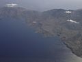
Mesochori from a bird's eye view


literature
- Antje Schwab, Gunther Schwab: Karpathos . Verlag Michael Müller, Cologne 2010, ISBN 978-3-89953-537-2 .
Individual evidence
- ↑ National Statistical Service of Greece (ΕΣΥΕ) according to 2001 census , p. 110 (PDF, 793 kB)
- ↑ a b Results of the 2011 census, Greek Statistical Office (ΕΛ.ΣΤΑΤ) ( Memento from June 27, 2015 in the Internet Archive ) (Excel document, 2.6 MB)
- ↑ Population of Mesochori 1947–2001, Greek Statistical Office ELSTAT, Digital Library (Greek)