
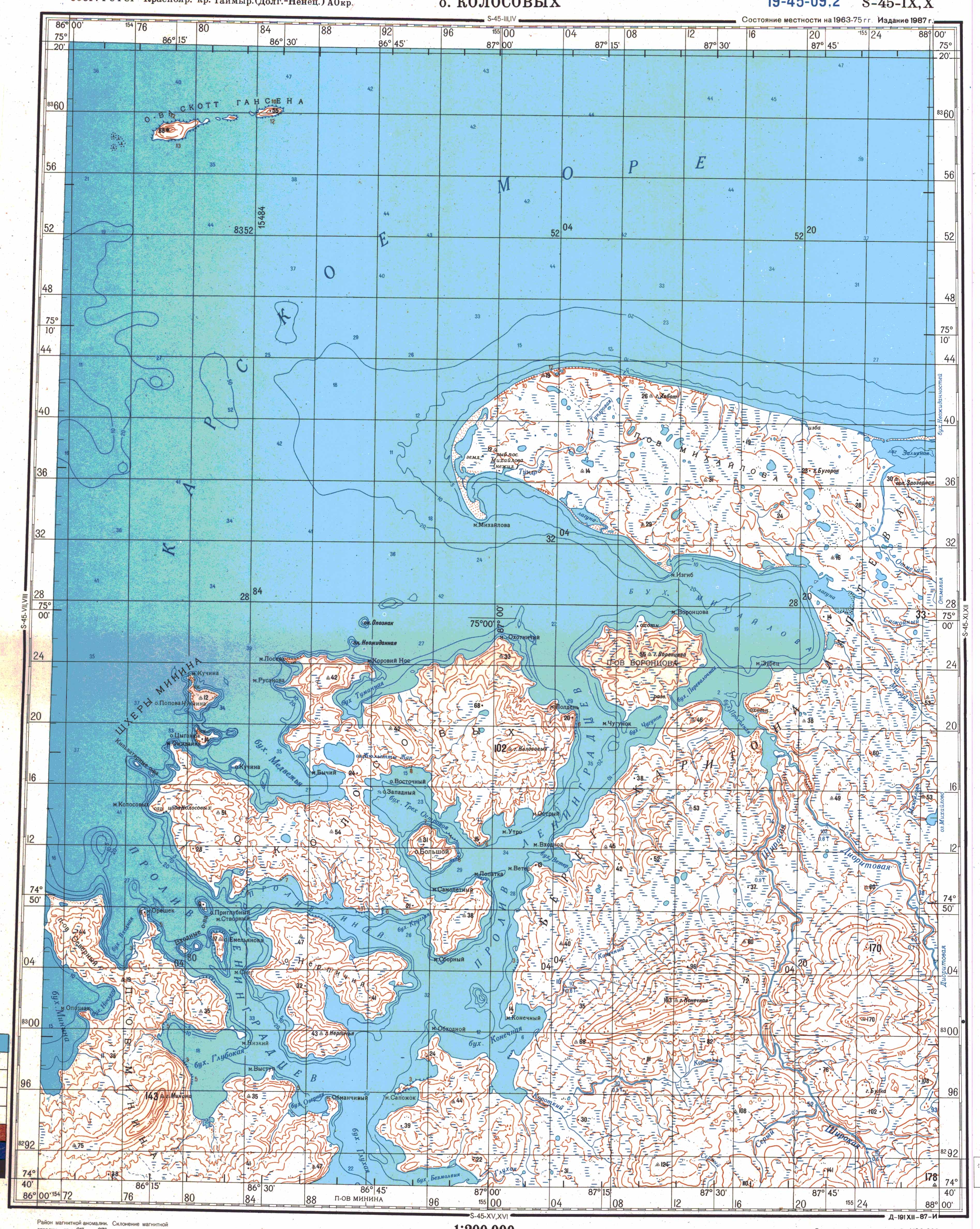
Mikhailov Peninsula
|
Mikhailov Peninsula Полуостров Михайлова |
||
 Mikhailov Peninsula satellite photo ( NASA ) |
||
| Geographical location | ||
|
||
| Coordinates | 75 ° 5 ' N , 87 ° 25' E | |
| Waters 1 | Kara Sea | |
| Waters 2 | Mikhailov Bay | |
| length | 29 km | |
| width | 12 km | |
| surface | 258 km² | |

The Mikhailov Peninsula ( Russian Полуостров Михайлова , scientific transliteration Poluostrov Michajlova ) is a peninsula in northern Siberia . Administratively it belongs to the Taimyrski Dolgano-Nenezki Rajon of the Russian Krasnoyarsk region . It is named after the Russian general Konstantin Ivanovich Michailow (1838–1918), an active member of the Imperial Russian Geographical Society .
geography
The peninsula, up to 12 kilometers wide, is located on the Chariton-Laptev coast in the western part of the larger Taimyr peninsula . It extends from the Otmelaja River in the east, 29 kilometers to the west. In the north the peninsula borders on the open Kara Sea , in the south on the Mikhailov Bay, which is divided into an inner and an outer area at the level of Cape Isgib by the Vorontsov peninsula opposite. To the southwest lies the island of Kolosowych , the largest of the Minin archipelago , and to the northwest, about 25 km away, are the Scott Hansen Islands . At the tip of the Mikhailov Peninsula, a spit formed several kilometers in an arc, first to the south and then to the southeast , which ends at Cape Mikhailov. The interior of the peninsula consists of flat, swampy tundra with numerous lakes. The largest flowing water is the Tundrowaya, which flows into the outer Mikhailov Bay. There are beach lakes in several places on the mostly flat coasts . The north coast also has steep sections. The highest point is in the center and is 31 m high . Only a few of the hills are named like the Gora Chabot ( 26 m ) in the north and the Gora Bugorok ( 23 m ) in the east.
The Mikhailov Peninsula is uninhabited. For emergencies there is an open winter hut on the south coast with supplies of provisions and fuel . On the northwest coast there is one of the beacons marking the northern sea route on a 13 m high pyramid-shaped wooden scaffolding tower. Its height of fire is 35 m , the range of the lightning , which is emitted every 9 seconds, is 10 nautical miles.
history
In 1921, a Russian-Norwegian expedition led by Nikifor Begitschew (1874-1927) came to the Mikhailov Peninsula in search of two participants in Roald Amundsen's Maud expedition . Peter Lorents Tessem (1875–1919) and Paul Knudsen (1889–1919) set out on October 15, 1919 with a dog sled from Maud , which was frozen in Wilkizkistraße , but did not reach their destination, Dikson , 800 km away . Begichev found a storage place on Mikhailov Bay with charred bones, the remains of a pocket barometer , a pocket knife , parts of a glasses frame, a French coin, buckles, buttons, rifle cartridges, nails and other small objects. Believing they found one of the missing Norwegians, they buried the bones and erected a grave cross. When Nikolai Urwanzew found the skis of both Norwegians further west a year later and finally the body of Peter Tessem, it was obvious that the camp on the bay could not be assigned to the Norwegians. It is therefore now assumed that it can be traced back to Vladimir Russanov's expedition , which went missing in 1913 and whose traces were also found on some islands in the area.
Web links
- Topographic map Ostrow Kolosowych (1: 200.000, Bl. S-45-IX, X, Ed. 1987)
Individual evidence
- ↑ GP Awetissow: Mikhailov Konstantin Ivanovich (14.09.1838-14.10.1918) . In: Imena na Karte Rossijskoi Arktiki , Nauka, Sankt Petersburg 2003, ISBN 5-02-025003-1 (Russian).
- ↑ a b Sailing Directions (Enroute). North Coast of Russia. Pub. 183, National Geospatial-Intelligence Agency, Springfield, Virginia 2017, p. 121.
- ↑ Russ Rowlett: Lighthouses of Russia: Taymyria ( English ) In: The Lighthouse Directory . University of North Carolina at Chapel Hill . Retrieved November 4, 2019.
- ^ List of Lights, Radio Aids and Fog Signals. Pub. 115: Norway, Iceland and Arctic Ocean (PDF; 2.9 MB), National Geospatial-Intelligence Agency , Bethesda, Maryland, 2007, p. 251 (English).
- ^ A b William Barr: The Last Journey of Peter Tessem and Paul Knutsen, 1919 . In: Arctic . tape 36 , no. 4 , 1983, p. 311–327 (English, ucalgary.ca [PDF; 2.5 MB ]).