Michelsberg (Palatinate)
| Michelsberg | ||
|---|---|---|
|
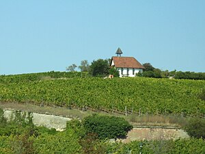
Michelsberg with the eponymous chapel |
||
| height | 147.4 m above sea level NHN | |
| location | Vorberg der Haardt | |
| Mountains | Palatinate Forest | |
| Coordinates | 49 ° 28 '5 " N , 8 ° 10' 24" E | |
|
|
||
| particularities | Michaelskapelle on the hilltop | |
The Michelsberg , sometimes also Michaelsberg , on the boundaries of the Palatinate district and spa town of Bad Dürkheim ( Rhineland-Palatinate ) is a 147.4 m high hill on the German Wine Route , on whose flat top there is a chapel .
On the hill was built in the 15th century Michaelis market , which later became today's Wurstmarkt was.
Geographical location
The hill, which is completely planted with vines, 1 km northeast of the residential area, is a foothill of the Haardt , which forms the eastern edge of the Palatinate Forest . The elevation lies in the area of the rift valley between the Palatinate Forest in the west and the Rhine plain in the east. The German Wine Route passes immediately to the east.
history
In 1155 a text written in Latin testified for the first time the "Monte sancti Michaelis". The name suggests that there was a shrine dedicated to the Archangel Michael with a corresponding house of God, whose patronage festival fell on Michael’s Day on September 29th. In later sources there is evidence of a Michael chapel , which was cared for by a clergyman and belonged to the Pfeffingen parish 300 m away and to which believers went on pilgrimages .
Increasing numbers of pilgrims attracted more and more farmers and winegrowers from the area for the Michael Festival , who transported their agricultural products with wheelbarrows to the Kapellenberg and offered the pilgrims mainly wine from the Palatinate , sausage and bread. Also dealers , jugglers and musicians found a, so that gradually developed a lively market activity. The new market soon gained supra-regional economic importance. Historians date the origin of what is now Michaelismarkt to the year 1417.
The market is documented for the first time in 1442, when the city of Speyer asked the noble lineage ruling the region for safe conduct for their merchants when they visited the fair on the Michelsberg, and Count Emich VII. Promised this in a document dated August 25, 1443 .
In 1449, the abbot of Limburg Abbey , located on the edge of the mountains above Dürkheim, issued a first market regulation and converted the market into a public church festival . In 1487, Peter Kercher, dean of the St. Guido monastery in Speyer , obtained indulgences from a total of eight cardinals for pilgrims and benefactors of the Michael's Chapel ; among them were Francesco Todeschini Piccolomini , who later became Pope Pius III. , a guardian of German interests in Rome, and Giuliano della Rovere , known as Pope Julius II , who laid the foundation stone for today 's St. Peter's Basilica .
In the 16th century, traders from all over the Palatinate came to the market . Not only fruit and vegetables as well as animals such as ox, horses or pigs were offered, but also wool and linen merchants, kesslers, furriers, white tanners, tinsmiths, saddlers, shoemakers, turners, hat makers, iron merchants and other professional groups kept their goods for sale.
Because of the cramped conditions on the Michelsberg, the Michaelismarkt was finally relocated down to the foot of the hill in 1577 on the approx. 45,000 m² Brühlwiesen , which extends to the left of the Isenach river at a height of 115 m . The festive event, now called Dürkheimer Wurstmarkt , still takes place there today.
The original Michaelskapelle was demolished in 1601 and only rebuilt in 1990 on a historical site.
Individual evidence
- ↑ Map services of the Federal Agency for Nature Conservation ( information )
- ↑ a b Map service of the landscape information system of the Rhineland-Palatinate Nature Conservation Administration (LANIS map) ( notes )
- ↑ Ernst Christmann: Field names between the Rhine and Saar . Publishing house of the Palatinate Society for the Advancement of Science, 1965, p. 51 ( detail scan ).
- ↑ Michael Frey : Attempt of a geographical-historical-statistical description of the royal. Bayer. Rhine circle . tape 2 ( Frankenthal Court District ). Speyer 1838, p. 415 f . ( Digital scan ).
- ^ Johann Georg Lehmann : Historical paintings from the Rhine district of Bavaria . tape 2 . Heidelberg 1834, p. 141 ( digital scan ).
- ^ Franz Xaver Glasschröder : New documents on the Palatinate church history in the Middle Ages . Publishing house of the Palatinate Society for the Advancement of Science, Speyer 1930, p. 74 (Deed No. 121).
- ^ Franz Xaver Glasschröder: Documents on the Palatinate Church History in the Middle Ages . Munich 1903, p. 226 (document regist No. 550).
- ↑ Michael's Chapel. bad-duerkheim.com, accessed on September 9, 2017 .
- ↑ Michael's Chapel. regionalgeschichte.net, accessed on April 22, 2018 .

