Mierendorffplatz
| Mierendorffplatz | |
|---|---|
| Place in Berlin | |
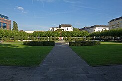
 Mierendorffplatz, northern part |
|
| Basic data | |
| place | Berlin |
| District | Charlottenburg |
| Created | 1897 |
| Newly designed | 1970 |
| Hist. Names | Gustav-Adolf-Platz |
| Confluent streets |
Mierendorffstrasse, Keplerstrasse, Osnabrücker Strasse, Brahestrasse, Lise-Meitner-Strasse, Kaiserin-Augusta-Allee, Nordhauser Strasse |
| use | |
| User groups | Pedestrians , cyclists , road traffic , public transport |
| Space design | fountain |
| Technical specifications | |
| Square area | Rectangle (120 m, 80 m) and triangle (120 m, 60 m, 80 m) |
The Mierendorffplatz is located in the Berlin district of Charlottenburg on the crossing Kepler street corner Empress-Augusta-Allee. From the approximately 9,000 m² area, Mierendorffstraße runs in the direction of Charlottenburg Palace and Kaiserin-Augusta-Allee in the direction of Moabit . It was named in 1950 after the social democratic politician, social scientist and writer Carlo Mierendorff .
The middle-class residential area around the square is also called Mierendorff- Kiez in Berlin vernacular . The historical name of the location, Kalowswerder , is hardly widespread. The Mierendorffkiez belongs to the Bundestag constituency Berlin-Spandau - Charlottenburg Nord .
The protected green area of the same name is a dedicated public green and recreational area. It was laid out in 1912–1913 based on a design by the landscape architect Erwin Barth and is protected as a garden monument.
Location and connection
The square is located in the center of the artificial island, which is enclosed by the Spree and the Charlottenburg connecting and Westhafenkanal . It consists of two parts: north of the street Mierendorffplatz it is designed as a rectangular decorative square with a fountain, south of the street as a triangular square area with a weekly market on Wednesdays and Saturdays .
Mierendorffplatz is the busy connection point between a bus line and the U7 line of the Berlin subway , whose subway station of the same name is located below the green area and was opened in 1980.
A district heating network pumping station from Vattenfall Wärme Berlin AG is located under the southern area of the square . It conveys up to 12,000 m³ of hot water per hour, corresponding to a heat transport capacity of 720 megawatts , and is thus the largest of its kind in Berlin. A 3.5 kilometer long tunnel connects the pumping station with the Reuter and Reuter West thermal power stations . Their supply radius is seven kilometers. The structure extends to a depth of around 23 meters and was built by Bewag in 1986/1987 using caisson construction.
history
When planning the surrounding residential area for ordinary people, the space was already taken into account in 1887. It was originally named after King Gustav II Adolf of Sweden in connection with the Reformation Quarter. It was not until 1912/1913 that the park was laid out according to the plans of the city's horticultural director Erwin Barth . In contrast to the magnificent and representative parks of the late 19th century, Mierendorffplatz is more functional, but at the same time sophisticated. The northern part of the square was again divided into two parts. In the eastern part a playground, in the west a flower garden was created, the axis of which is complemented by a fountain in the middle . Mainly roses were planted inside the square . The plant is bordered by plane trees .
After the Second World War , the square was initially used for allotment gardens. In 1950/1951 it was converted into a green area, which was then named after Mierendorff. After the construction of the underground station, which was built in the 1970s using the cut-and- cover method , it was possible to restore the square closely following Barth's plans. Fountains, benches, gates and lamps were reproduced true to the original. The Gustav Meyer Prize (named after the landscape designer Gustav Meyer ) was awarded in 2000 for the historical reconstruction . A plaque commemorates Barth.
Web links
- Mierendorffplatz. In: Street name lexicon of the Luisenstädtischer Bildungsverein (near Kaupert )
- Gustav-Adolf-Platz . In: Luise.
- History, plans, pictures of the square from the district office
- Mierendorffplatz at the Senate Department for Urban Development
- Old postcards with comparative photos to the present
- Entry in the Berlin State Monument List
Individual evidence
- ↑ Mierendorffplatz . Website of the Senate Department for the Environment, Transport and Climate Protection , accessed on May 15, 2019.
- ↑ Warmth from the depths - the Mierendorffplatz network pumping station . In: Berliner Kurier . December 4, 2018, p. 16 ff .
Coordinates: 52 ° 31 ′ 35.5 ″ N , 13 ° 18 ′ 18.3 ″ E

