
Mines in the Battle of Messines

The mines at the Battle of Messines were extensive underground tunnels that were opened by British troops near Mesen in Belgium under German positions on the Western Front during the First World War in the run-up to the Battle of Messines (June 7 to June 14, 1917) in the Wytschaete arch near Ypres .
history


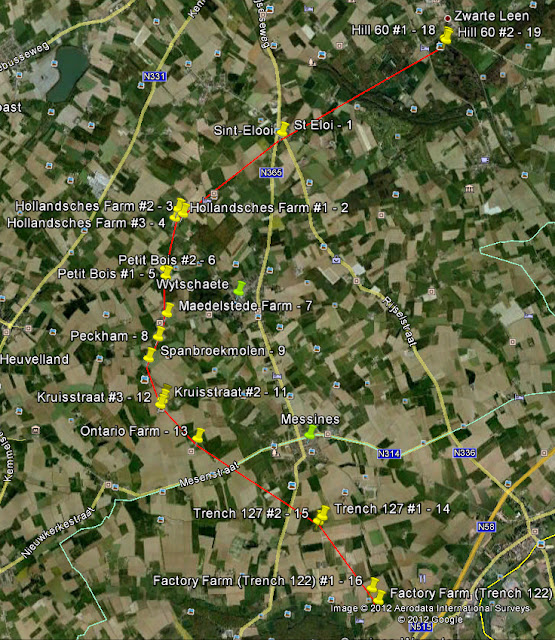
Sappers and miners or miners from all parts of the British Empire were used to build the mine shafts ; in the case of the mines near Messines, they came from England and Wales, Canada and Australia in particular. The opposing positions were undermined as much as possible, the tunnels were then filled with several tons of ammonal explosives and kept ready for use under the strictest secrecy, in some cases for several months. The length of the tunnel under the battlefield at Mesen was about 8,000 m; this also included the fiercely contested height 60 .
One of the mines ( La Petite Douve Farm ) was abandoned after discovery by German troops and not blown up, another one (Peckham 2) also abandoned after a tunnel collapse. Both of them, along with the Birdcage 1, 2 and 4 mines, are probably still fully charged and may still be ignitable. However, it can be assumed that the tunnels have now been completely flooded. The first mentioned mine with its 25 tons of explosives is considered to be the largest as yet unsecured explosive charge in the world. Birdcage 3 was also not blown up during World War I, but it remained armed and exploded in a thunderstorm in 1955. A cow was killed in the explosion. The exact position of three other not blown and sharply charged mines ( Birdcage 1 , 2 and 4 ) is no longer known.
At the start of the Battle of Messines on June 7, 1917 at 3:10 a.m., most of the tunnel mines built by the Allied troops were detonated, with the ignition taking place in an irregular sequence. It "rose nineteen gigantic roses with glowing red leaves or ... huge mushrooms ... slowly and majestically from the earth and then burst with a tremendous roar, where they shot bright columns of flame, mixed with earth and splinters, high into the sky". For example, one survivor remembered the detonation of more than 400 tons of explosives. The explosions created 19 huge explosive craters and wreaked havoc on the German positions along the front line. Parts of the 204th Württemberg Infantry Division , the 2nd and 35th Prussian Infantry Division and the Bavarian 4th Infantry Division were badly hit . The 3rd Bavarian Division, which was being relieved, and the Saxon 40th Infantry Division suffered heavy losses; up to 10,000 soldiers were killed. The German defense of the front section collapsed, the first line was completely overrun. Between 8:00 a.m. and 9:00 a.m., the British troops took Wijtschate and Mesen; they could only be stopped in the tendon position.
The Chief of Staff of the 2nd British Army, General Sir Charles Harington, wrote on the eve of the Battle of Messines: "I don't know if we will change history tomorrow, but in any case we will change the landscape." The mines exploded the loudest human-made sound to date and supposedly could reach Dublin and from Prime Minister David Lloyd George at No. Downing Street in London . 10 to be heard; it is considered to be one of the largest non-nuclear explosions of all time.
List of mines
| No. | Designation coordinates |
Explosive charge |
Tunnel length |
depth | construction commencing |
End of construction |
Whereabouts | comment |
|---|---|---|---|---|---|---|---|---|
| 1 |
Hill 60 50 ° 49 ′ 26 "N, 2 ° 55 ′ 44" E |
53,500 lbs | 354 m | 30 m | August 22, 1915 | August 1, 1916 | blown up on June 7, 1917 | Also referred to as " Hill 60 A " ; shared tunnel with Caterpillar . The access gallery with two explosive chambers ( Hill 60 A and Hill 60 B ), which was constructed as the Berlin Tunnel from the summer of 1915 , was one of the first Allied mines near Ypres. The mines originally planned for the Battle of Height 60 were eventually included in the plans for the Battle of Messines . In August 1916, the Berlin tunnel was damaged by water ingress and was restored from November 1916. Maintenance was made considerably more difficult by German counter tunnels. |
| 2 |
Caterpillar 50 ° 49 ′ 21 ″ N, 2 ° 55 ′ 44 ″ E |
70,000 lbs | 427 m | 33 m | August 22, 1915 | October 18, 1916 | blown up on June 7, 1917 | Also referred to as " Hill 60 B " ; the facility consisted of a common access tunnel ( Berlin Tunnel ) with two blasting chambers ( Hill 60 A and Hill 60 B ). For the history of the mines below height 60, see the explanations above. |
| 3 |
St Eloi 50 ° 48 ′ 32 "N, 2 ° 53 ′ 39" E |
95,600 lbs | 408 m | 42 m | August 16, 1915 | June 11, 1916 | blown up on June 7, 1917 | Largest single explosion in the Battle of Messines, in which a double explosion crater from 1916 was also destroyed. The maintenance of the finished 95,600 lbs mine had been made considerably more difficult by German counter tunnels. Location today next to another double explosion crater from 1916. |
| 4th |
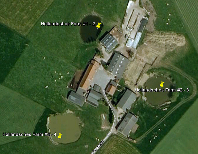
Hollandscheschur Farm 1 50 ° 47 ′ 50 ″ N, 2 ° 52 ′ 7 ″ E |
34,200 lbs | 251 m | 20 m | December 18, 1915 | June 20, 1916 | blown up on June 7, 1917 | Location around the former German Günther position, not far from the Bayernwald position between Wijtschate and Voormezele. The facility consisted of three blasting chambers ( Hollandscheschur Farm 1, 2, 3 ) with a common access tunnel. Maintenance was made considerably more difficult by German counter tunnels. Aerial photo 2 . |
| 5 |
Hollandscheschur Farm 2 50 ° 47 ′ 50 ″ N, 2 ° 52 ′ 7 ″ E |
14,900 lbs | 137 m | 18 m | December 18, 1915 | July 11, 1916 | blown up on June 7, 1917 | Location around the former German Günther position, not far from the Bayernwald position between Wijtschate and Voormezele. The facility consisted of three blasting chambers ( Hollandscheschur Farm 1, 2, 3 ) with a common access tunnel. Maintenance was made considerably more difficult by German counter tunnels. Aerial photo 2 . |
| 6th |
Hollandscheschur Farm 3 50 ° 47 ′ 50 ″ N, 2 ° 52 ′ 7 ″ E |
17,500 lbs | 244 m | 18 m | December 18, 1915 | August 20, 1916 | blown up on June 7, 1917 | Location around the former German Günther position, not far from the Bayernwald position between Wijtschate and Voormezele. The facility consisted of three blasting chambers ( Hollandscheschur Farm 1, 2, 3 ) with a common access tunnel. Maintenance was made considerably more difficult by German counter tunnels. Aerial photo 2 . |
| 7th |
Petit Bois 1 50 ° 47 '19 "N, 2 ° 51' 55" E |
30,000 lbs | 616 m | 19 m | December 16, 1915 | July 30, 1916 | blown up on June 7, 1917 | Location west of Wijtschate . The facility consisted of two blasting chambers ( Petit Bois 1, 2 ) with a common access tunnel. Mine severely damaged by German counter tunnels, but restored in good time before it was detonated in the Battle of Messines. Aerial view of the double explosion crater |
| 8th |
Petit Bois 2 50 ° 47 '19 "N, 2 ° 51' 55" E |
30,000 lbs | 631 m | 23 m | December 16, 1915 | August 15, 1916 | blown up on June 7, 1917 | Location west of Wijtschate . The facility consisted of two blasting chambers ( Petit Bois 1, 2 ) with a common access tunnel. Mine severely damaged by German counter tunnels, but restored in good time before it was detonated in the Battle of Messines. Aerial view of the double explosion crater |
| 9 |
Maedelstede Farm 50 ° 46 ′ 58 ″ N, 2 ° 51 ′ 57 ″ E |
94,000 lbs | 518 m | 33 m | September 3, 1916 | June 2, 1917 | blown up on June 7, 1917 | Location west of Wijtschate . The plant was originally designed as studs with two blasting chambers ( Wytschaete Wood , Maedelstede farm planned), for the removal of excavated own railway track was built. Due to time constraints , the Wytschaete Wood mine was not built, but the Maedelstede Farm mine was completed on time. Aerial view of the explosion crater |
| 10 |
Peckham 1 50 ° 46 '47 "N, 2 ° 51' 50" E |
87,000 lbs | 349 m | 23 m | December 20, 1915 | June 19, 1916 | blown up on June 7, 1917 | The completed system consisted of two blasting chambers ( Peckham 1, 2 ) with a common access tunnel, of which Peckham 1 was detonated in the Battle of Messines. King George V visited the explosion crater in July 1917. Today it is considered the largest surviving crater in the Messines mines. Illustration of the explosion crater |
| 11 |
Peckham 2 50 ° 46 ′ 52 ″ N, 2 ° 51 ′ 56 ″ E (presumed) |
20,000 lbs | 122 m | 23 m | December 20, 1915 | December 1916 | Abandoned after the tunnel break in and not ignited | Location under a farmhouse. The completed system consisted of two blasting chambers ( Peckham 1, 2 ) with a common access tunnel , of which Peckham 2 was abandoned after a tunnel break in and not detonated. |
| 12 |
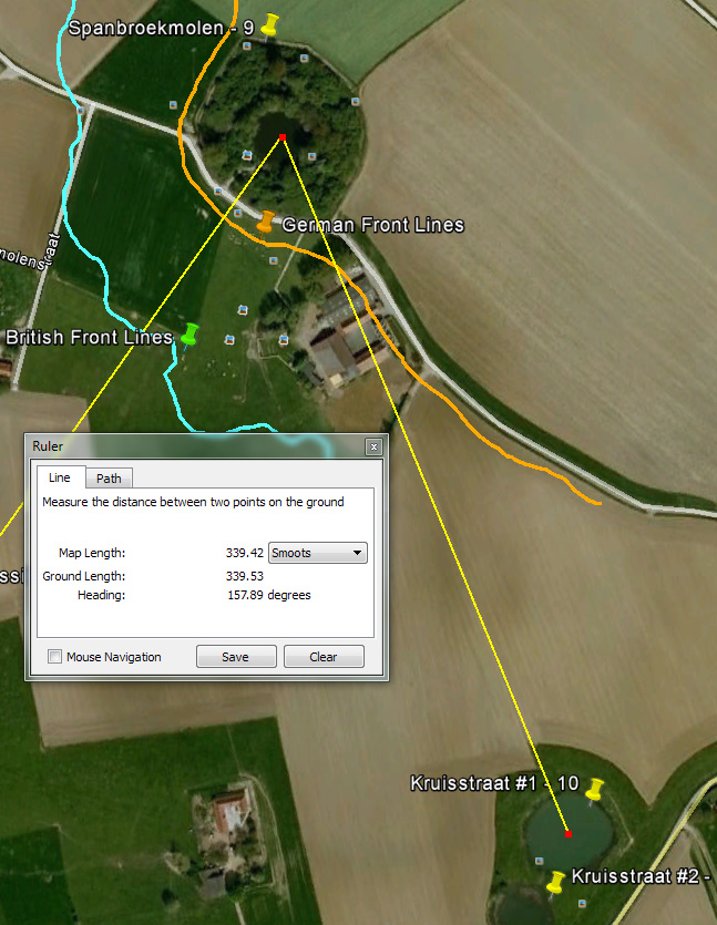
Chip broekmoles 50 ° 46 ′ 33 ″ N, 2 ° 51 ′ 42 ″ E |
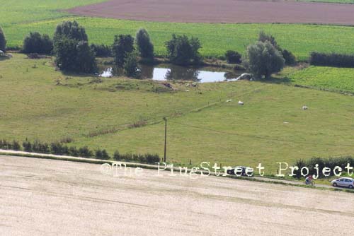
91,000 lbs | 521 m | 29 m | January 1, 1916 | June 26, 1916 | blown up on June 7, 1917 | This mine was located at one of the highest points of the range of hills around Messines. It was discovered by German troops in February 1917, later recovered and used in the Battle of Messines. Later also called " Lone Tree Crater "; Bought in 1929 by the Toc H Foundation in Poperinge , today the “ Pool of Peace ” memorial . Illustration of the explosion crater |
| 13 |
Kruisstraat 1 50 ° 46 ′ 15 ″ N, 2 ° 51 ′ 53 ″ E |
30,000 lbs | 492 m | 19 m | January 2, 1916 | July 5, 1916 | blown up on June 7, 1917 | Shared tunnel with Kruisstraat 4 , ignited together. Preparations for construction of a double mine from December 1915. The first explosive charge of 30,000 lbs was placed at the end of a 492 m long tunnel, the second ( Kruisstraat 2 ) about 50 meters to the right. A third charge ( Kruisstraat 3 ) was attached two months later, and a fourth charge ( Kruisstraat 4 ) in 1917. Of the once four explosion craters, two are still preserved today, probably from the first and second explosive charges. Images of the double explosion crater: image 1 , image 2 , image 3 |
| 14th |
Kruisstraat 2 50 ° 46 ′ 15 ″ N, 2 ° 51 ′ 53 ″ E |
30,000 lbs | 451 m | 21 m | January 2, 1916 | August 23, 1916 | blown up on June 7, 1917 | Construction preparations for a double mine from December 1915. The second explosive charge of 30,000 lbs was positioned around 50 meters to the right of the first ( Kruisstraat 1 ). A third charge ( Kruisstraat 3 ) was attached two months later, and a fourth charge ( Kruisstraat 4 ) in 1917. Of the once four explosion craters, two are still preserved today; Images of the double explosion crater: image 1 , image 2 , image 3 |
| 15th | Kruisstraat 3 | 30,000 lbs | 658 m | 17 m | January 2, 1916 | August 23, 1916 | blown up on June 7, 1917 | Two months after the charges from the original double mine Kruisstraat 1 and Kruisstraat 2 , a third explosive charge, also weighing 30,000 lbs, was installed, which also had the longest tunnel of all mines near Messines. A fourth load was added in the course of repairs in 1917 ( Kruisstraat 4 ). Of the once four explosion craters, two are still preserved today, probably from the first and second explosive charges. |
| 16 | Kruisstraat 4 | 19,500 lbs | 492 m | 19 m | February 1917 | July 5, 1917 | blown up on June 7, 1917 | Shared tunnel with Kruisstraat 1 , ignited together. When the tunnel of the original twin mine was damaged by a German countermine in February 1917, a fourth load of 19,500 lbs was added as part of the repairs . Of the once four explosion craters, two are still preserved today, probably from the first and second explosive charges. |
| 17th | Ontario Farm | 60,000 lbs | 392 m | 34 m | January 28, 1917 | June 6, 1917 | blown up on June 7, 1917 | Location west of Mesen . During the explosion, this mine did not leave a crater in the soft clay soil, just a slight depression in the terrain. |
| 18th |
La Petite Douve Farm 50 ° 45 ′ 11 "N, 2 ° 51 ′ 55" E |
50,000 lbs | 518 m | 23 m | January 28, 1916 | completed | abandoned after discovery by German troops and not ignited | Location under the barn of today's farm " La Basse Cour "; the mine has not yet been defused. The mine under construction was discovered, flooded and abandoned on August 24, 1916 through a German counter-tunnel. |
| 19th |
Trench 127 Left 50 ° 44 ′ 55 ″ N, 2 ° 54 ′ 14 ″ E (approximate) |
36,000 lbs | 302 m | 25 m | December 28, 1915 | April 20, 1916 | blown up on June 7, 1917 | Location east of St. Yvon / St. Yves, also called " Trench 127 North ". The explosion crater was filled with rubble towards the middle of the 20th century and is no longer visible today. He was in a field not far from the Khaki Chums Cross memorial. |
| 20th |
Trench 127 Right 50 ° 44 ′ 51 ″ N, 2 ° 54 ′ 17 ″ E |
50,000 lbs | 405 m | 26 m | December 28, 1915 | May 9, 1916 | blown up on June 7, 1917 | Location east of St. Yvon / St. Yves, also called " Trench 127 South " or " Ash Crater ". It is located in a field not far from the Khaki Chums Cross memorial, but has now been partially filled. |
| 21st |
Trench 122 Left 50 ° 44 ′ 36 "N, 2 ° 54 ′ 45" E |
20,000 lbs | 296 m | 20 m | February 1916 | April 14, 1916 | blown up on June 7, 1917 | Location east of St. Yvon / St. Yves, also known as " Factory Farm 1 " or " Ultimo Crater ", is now surrounded by a mound of rubble and trees. Construction preparations for a double mine beginning in the Trench 122 trench system from January 15, 1915. After the first explosive charge of 20,000 lbs was ready for use in May 1916, a second was installed under the “ Factory Farm ”. Illustration of the explosion crater |
| 22nd |
Trench 122 Right 50 ° 44 ′ 30 "N, 2 ° 54 ′ 47" E |
40,000 lbs | 241 m | 25 m | February 1916 | June 11, 1916 | blown up on June 7, 1917 | Location east of St. Yvon / St. Yves, also called " Factory Farm 2 " or " Factory Farm Crater ". Preparations for construction of a double mine beginning in the Trench 122 trench system from January 15, 1915. After the first explosive charge was ready, a second of 40,000 lbs was at the end of a 200 m long junction located under the “ Factory Farm ”. Images of the explosion crater: image 1 , image 2 . |
| 23 |
Birdcage 1 50 ° 44 ′ 21 ″ N, 2 ° 54 ′ 27 ″ E (approximately) |
20,000 lbs | 130 m | 18 m | December 1915 | March 7, 1916 | not ignited | Also referred to as trench 121 ; five mines were planned here, four of which (Birdcage 1-4) were built. Location east of Ploegsteert at the former German birdcage position, so called by the British, near Le Pelerin at the southern end of the ridge near Ypres. Not detonated because the mine was too far from the front line at the time of the attack. The position of this mine is only roughly known. |
| 24 |
Birdcage 2 50 ° 44 ′ 20 ″ N, 2 ° 54 ′ 28 ″ E (approx.) |
32,000 lbs | 236 m | 18 m | December 1915 | completed | not ignited | Also referred to as trench 121 ; five mines were planned here, four of which (Birdcage 1-4) were built. Location east of Ploegsteert at the former German birdcage position, so called by the British, near Le Pelerin at the southern end of the ridge near Ypres. Not detonated because the mine was too far from the front line at the time of the attack. The position of this mine is only roughly known. |
| 25th |
Birdcage 3 50 ° 44 ′ 20 "N, 2 ° 54 ′ 31" E |
26,000 lbs | 261 m | 20 m | December 1915 | April 30, 1916 | not detonated, exploded on June 17, 1955 during a thunderstorm | Also referred to as trench 121 ; five mines were planned here, four of which (Birdcage 1-4) were built. Location east of Ploegsteert at the former German birdcage position, so called by the British, near Le Pelerin at the southern end of the ridge near Ypres. Not detonated because the mine was too far from the front line at the time of the attack. Exploded in 1955 during a thunderstorm, killing a cow. The explosive funnel had a diameter of 40 meters and was filled again soon afterwards, but is still clearly visible from the air. He was in a pasture east of the Ploegsteerter forest next to the Huttebergweg. |
| 26th |
Birdcage 4 50 ° 44 ′ 20 ″ N, 2 ° 54 ′ 30 ″ E (approximate) |
34,000 lbs | 239 m | 18 m | December 1915 | completed | not ignited | Also referred to as trench 121 ; five mines were planned here, four of which (Birdcage 1-4) were built. Location east of Ploegsteert at the former German birdcage position, so called by the British, near Le Pelerin at the southern end of the ridge near Ypres. Not detonated because the mine was too far from the front line at the time of the attack. The position of this mine is only roughly known. |
photos

Mine crater from 1917 at Caterpillar
Mine crater from 1917 at height 60
Entrance to the "Berlin Tunnel", which leads to Hill 60 and the mines at Caterpillar

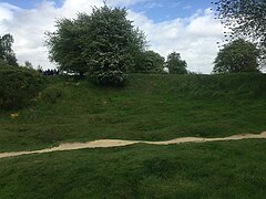
Mine crater from 1917 near Spanbroekmolen

View from Spanbroekmolen crater towards the Kruisstraat crater

Crater of one of the Kruisstraat mines that was blown up in 1917, view towards the Spanbroekmolen crater


See also
literature
- Alexander Turner: Messines 1917. The Zenith of Siege Warfare. (= Campaign Series , Vol. 225.) Osprey Publishing, 2010, ISBN 978-1-84603-845-7 .
- Tonie Holt, Valmai Holt: Major & Mrs. Holt's Battlefield Guide to the Ypres Salient & Passchendaele. Pen & Sword Books Ltd., Barnsley 2014, ISBN 978-0-85052-551-9 , pp. 247-251.
Individual evidence
- ^ Neil Tweedie: Farmer who is sitting on a bomb. In: The Telegraph . January 12, 2004 (online) , accessed February 15, 2015.
- ↑ arte.tv ( Memento of the original dated November 12, 2017 in the Internet Archive ) Info: The archive link was inserted automatically and has not yet been checked. Please check the original and archive link according to the instructions and then remove this notice.
- ↑ Florian Stark, The largest conventional explosion hit Bavaria , in: Die Welt , November 20, 2014 ( welt.de ).
- ↑ James Edmonds (ed.): History of the Great War, based on official documents. Volume 4: Military Operations France and Belgium 1917. Volume 2: 7 June - 10 November. Messines and Third Ypres (Passchendaele). Macmillan, London 1948. p. 55.
- ↑ Reichsarchiv Volume 27, p. 18 ff.
- ↑ a b c Messines , accessed February 16, 2015.
- ↑ a b c d Turner, Messines 1917 (2010), p. 44.
- ^ A b "Major & Mrs Holt's Battlefield Guide to the Ypres Salient & Passchendaele", pp. 116-119 and 247-248.
- ^ Image of the St. Eloi position on April 1, 1916 after the explosion of two double mines (aviator photograph) . The two mines on the left were destroyed by the detonation of the St. Eloi mine on June 7, 1917.
- ↑ a b c d e f g h i j k “Major & Mrs Holt's Battlefield Guide to the Ypres Salient & Passchendaele”, p. 248.
- ↑ a b c d e f g h i j k l m n o Photo gallery: Battle of Messines Ridge ( Memento of the original from February 24, 2015 in the Internet Archive ) Info: The archive link was automatically inserted and not yet checked. Please check the original and archive link according to the instructions and then remove this notice. , Accessed February 16, 2015.
- ^ A b c "Major & Mrs Holt's Battlefield Guide to the Ypres Salient & Passchendaele", p. 249.
- ↑ a b c d e f Messines , accessed on February 16, 2015.
- ↑ a b c The British journalist Neil Tweedie wrote about it in 2004: “The Battle of Messines was regarded as the most successful local operation of the war. But it left a legacy: six mines were not used. Four on the extreme southern flank were not required because the ridge fell so quickly, and another, a 20,000 lb mine codenamed Peckham, was abandoned before the attack due to a tunnel collapse . The sixth, and one of the biggest, was planted under a ruined farm called La Petite Douve. It was lost when the Germans mounted a counter-mining attack, and never used. After the war, La Petite Douve was rebuilt by its owners, the Mahieu family, and later renamed La Basse Cour. The mine is beneath a barn, next to the farmhouse. "(Neil Tweedie: Farmer who is sitting on a bomb. In: The Telegraph. January 12, 2004 (online) , accessed February 15, 2015)
- ^ "Major & Mrs Holt's Battlefield Guide to the Ypres Salient & Passchendaele," pp. 192–193.
- ↑ a b With the British Army in Flanders: A Tour of Ploegsteert Wood Part 5 - The Kruisstraat Craters , accessed on February 16, 2015.
- ^ A b c d “Major & Mrs Holt's Battlefield Guide to the Ypres Salient & Passchendaele”, pp. 193–194.
- ↑ a b c d The Western Front Today - Kruisstraat Craters ( online ), accessed April 16, 2015.
- ↑ ypres1917.fr.yuku.com
- ↑ a b c d With the British Army in Flanders: A Tour of Ploegsteert Wood Part 12 , accessed on February 16, 2015.
- ↑ a b c d e f Peter Pedersen, ANZACS on the Western Front: The Australian War Memorial Battlefield Guide ( books.google.at online )
- ^ A b c "Major & Mrs Holt's Battlefield Guide to the Ypres Salient & Passchendaele", p. 251.
- ↑ a b c d e f With the British Army in Flanders: A Tour of Ploegsteert Wood Part 11 - Le Gheer & the Birdcage , accessed on February 16, 2015.
- ↑ a b c d Site plan ( Memento of the original from February 17, 2015 in the Internet Archive ) Info: The archive link was inserted automatically and has not yet been checked. Please check the original and archive link according to the instructions and then remove this notice. , Accessed February 16, 2015.
- ↑ a b c d Christoph Gunkel: Mine use in the First World War. In: Der Spiegel. October 21, 2014 (online) , accessed February 16, 2015.
Web links
- Site map of the mines at the Battle of Messines
- Map of the mines (Google Earth)
- Florian Stark, The biggest conventional explosion hit Bavaria , in: Die Welt , November 20, 2014 ( online )
- Messines (English), with images of the explosion craters
- With the British Army in Flanders (English)
- Battle of Messines Ridge , with images of the explosion craters
- Discussion of unexploded mines (English)
- The Western Front Today - Messines (English)