Mirna (Save)
| Mirna | ||
|
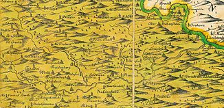
The Neuring (Mirna) in Lower Carniola, section of map, Johannes Dismas Floriantschitsch, 1744. |
||
| Data | ||
| location | Dolenjska / Lower Carniola , Slovenia | |
| River system | Danube | |
| Drain over | Save → Danube → Black Sea | |
| source | not far from Velika Goba ( Litija municipality ) | |
| Source height | 690 m | |
| muzzle | at Dolenji Boštanj (opposite Sevnica ) in the Save coordinates: 46 ° 0 ′ 29 ″ N , 15 ° 17 ′ 39 ″ E 46 ° 0 ′ 29 ″ N , 15 ° 17 ′ 39 ″ E |
|
| Mouth height | 181 m | |
| Height difference | 509 m | |
| Bottom slope | 12 ‰ | |
| length | 44 km | |
| Left tributaries | Gabrovščica, Kamnarica, Homščica, Lipoglavščina, Sotla (Mirna), Busenk, Bistrica, Jeseniščica, Pijavški potok, Hinja, Kamenca, Grahovica | |
| Right tributaries | Slepšek, Turnska Cerknica, Cerknica, Dušica, Vejar, Zabrščica, Glinški potok, Bačji potok, Savrica, Stajniški potok, Kanopljin potok, Tržiški potok, Sklepnica, Radovan | |
The Mirna (German: Neuring, Neiring , or Neyring ) is a 44 km long right tributary of the Save and flows through the historic region of Lower Carniola in Slovenia .
geography
course
The source water of the Mirna / Neuring rises at an altitude of 690 m not far from the hamlet of Velika Goba in the municipality of Litija / Littai. The headwaters are in the middle of the Sava hill country / Posavsko hribovje. At first the water flows in a southerly direction. After just 5 km, near the village of Moravče pri Gabrovki / Moräutsch, the brook has climbed 340 meters. From here the water meanders in a south-easterly direction, only to pivot to the east after another 5 km.
Shortly below the village of Migolica / Migoutzberg, the stream enters the central part of the Mirna valley / Mirnska dolina , a valley basin up to 3 km wide, in which the larger towns of Mirna / Neudegg, Šentrupert / Sankt Ruprecht and Mokronog / Nassenfuß are also located.
From the place Pijavice / Piauze the river is again forced into a narrow valley. It now passes this hill country, partly in tight turns and loops, and flows into the Save at Dolenji Boštanj / Unter Savenstein. The Lower Styrian town of Sevnica / Lichtenwald is located opposite the mouth of the river, 181 m .
Catchment area and backwaters
The catchment area of the Mirna / Neuring is approximately 300 square kilometers and, as a natural geographic region of Slovenia, is called Mirnska dolina.
The most important stream inflows and tributaries from the upper reaches to the mouth are:
- Left tributaries: Gabrovščica, Kamnarica, Homščica, Lipoglavščina, Sotla, Busenk, Bistrica, Jeseniščica, Pijavški potok, Hinja, Kamenca, Grahovica.
- Right tributaries: Slepšek, Turnska Cerknica, Cerknica, Dušica, Vejar, Zabrščica, Glinški potok, Bačji potok, Savrica, Stajniški potok, Kanopljin potok, Tržiški potok, Sklepnica, Radovan.
history
The river was first mentioned on April 15, 1016 in a deed of donation issued by Emperor Heinrich II in Bamberg to Count Wilhelm von Sanngau with the name Nirine . King Conrad II confirmed these donations to Count Wilhelm on May 11, 1025 and, as emperor, on December 30, 1028.
After the count's death in 1036, the area around the Neuring river also fell to his wife Hemma, and through her, the land was transferred to the Gurk convent and the Gurk diocese, which was later established there, in 1043 .
Baron Johann Weichard von Valvasor describes the Mirna River in his work, Die Ehre des Hertzogthums Crain , published in 1689 , with the words: “The Neyring swells by Gallenstein / and wanders several miles around / bit / between Sauenstein and Tarischendorff / the Sau stream you Stop / and through them / stiffen. It stimulates a lot of grain and Saeg mills / and carries all kinds of fish. "
Individual evidence
- ^ RI II, 4 n.1879 .
- ↑ RI III, 1 n.139 .
- ^ Johann Weichard von Valvasor: The honor of the Hertzogthums Crain . Facsimile edition, ed. Rudolf Trofenik , Munich 1971.
