Šentrupert
| Šentrupert | |||
|
|||
| Basic data | |||
|---|---|---|---|
| Country |
|
||
| Historic region | Lower Carniola / Dolenjska | ||
| Statistical region | Jugovzhodna Slovenija (Southeast Slovenia) | ||
| Coordinates | 45 ° 59 ' N , 15 ° 5' E | ||
| height | 274 m. i. J. | ||
| surface | 42 km² | ||
| Residents | 2,419 (2008) | ||
| Population density | 58 inhabitants per km² | ||
| Post Code | 8232 | ||
| License Plate | NM | ||
| Structure and administration | |||
| Mayor : | Rupert Gole | ||
| Website | |||
Šentrupert ( German : Sankt Ruprecht , also Sankt Rupert ) is a municipality in the Dolenjska region in Slovenia .
Location and inhabitants
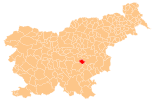
2419 people live in the total community, which consists of 25 villages and hamlets. The main town Šentrupert alone has 348 inhabitants. The municipality is located northwest of Novo mesto .
Districts of the entire municipality
- Bistrica , (German Feistritz near Sankt Rupert )
- Brinje , (German Bründl )
- Dolenje Jesenice , (German Unterjassenitz )
- Draga pri Šentrupertu , (German Draga near Sankt Rupert )
- Gorenje Jesenice , (German Oberjassenitz )
- Hom , (German Hom )
- Hrastno , (German Aich )
- Kamnje , (German Steindorf , also Steinach )
- Kostanjevica , (German Kästendorf )
- Mali Cirnik pri Šentjanžu , (German: Klein Zirnig )
- Okrog , (German Saint Barbara )
- Prelesje , (German Prellesnigg )
- Ravne nad Šentrupertom , (German Raunach , also Raun )
- Rakovnik pri Šentrupertu , (German Krebsenbach )
- Ravnik , (German Raunitz near Sankt Rupert )
- Roženberk , (German Rosenberg )
- Slovenska vas , (German village near Wazenberg )
- Straža , (German Wazenberg near Sankt Rupert )
- Šentrupert , (German Sankt Rupert )
- Škrljevo , (German Grailach Castle )
- Trstenik , (German Terstenig near Sankt Rupert )
- Vesela Gora , (German Freudenberg )
- Vrh , (German mountain , also Werch near Sankt Rupert)
- Zabukovje , (German book )
- Zaloka , (German Sallach )
history
The area around Šentrupert was inhabited since the earliest times, as archaeological excavations show. Traces from the Hallstatt period were found .
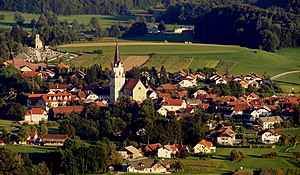
The Gothic church of St. Rupert in Šentrupert was built around the year 1450. Due to its thickness and aesthetic perfection, it is one of the most beautiful Gothic church buildings in Slovenia.
On June 14, 2006 Šentrupert separated from the municipality of Trebnje and has since formed its own municipality.
Web links
Individual evidence
- ^ Church of St. Rupert ( Memento from January 18, 2016 in the Internet Archive )


