
Mitchell River (Gippsland Lakes)
| Mitchell River | ||
 Mitchell River at Bairnsdale |
||
| Data | ||
| location | Victoria , Australia | |
| River system | Latrobe River | |
| Drain over | Gippsland Lakes → Bass Strait | |
| source | Horseshoe Bend 37 ° 23 ′ 42 ″ S , 147 ° 6 ′ 16 ″ E |
|
| Source height | 137 m | |
| muzzle |
Lake King Coordinates: 37 ° 51 ′ 30 " S , 147 ° 44 ′ 25" E 37 ° 51 ′ 30 " S , 147 ° 44 ′ 25" E |
|
| Mouth height | 1 m | |
| Height difference | 136 m | |
| Bottom slope | 1.1 ‰ | |
| length | 121 km | |
| Left tributaries | Wentworth River | |
| Right tributaries | Wonnangatta River | |
| Medium-sized cities | Bairnsdale | |
| Small towns | Cobbannah, Wy Yung, Lucknow | |
The Mitchell River is the longest unregulated river in the Australian state of Victoria and is a unique example of pristine riparian forest . The main tributaries are the Wentworth River and the Wonnangatta River , all of which are surrounded by dense jungle on the steep slopes of the Australian Alps . The river flows first east and then southeast to Lake King , one of the Gippsland lakes .
geography
According to the Land Conservation Council Rivers & Streams Special Investigation 1990 , the river landscape is "an important example of a large-scale ecosystem as it used to be found all over southeast Australia." In 1992 the Mitchell River was added to the list of natural monuments of Australia.
The Mitchell River National Park is located on the middle reaches of the Mitchell River, where it flows between high rock faces through various gorges. The Den of Nargun , the cave of the Nargun , a being from local Aboriginal legends, is located about one kilometer from the Mitrchell River on the tributary Woolshed Creek. The Mitchell River was an important place for the Kurnai , especially the Brabuwooloong and Brayakuloong tribes who lived in central Gippsland .
The upper reaches of the Wonnongatta River and the Dargo River were mapped in 1850. From the 1860s, Bairnsdale developed as a port city on the Mitchell River, which is navigable up to a few kilometers above the city. The Gippsland Lakes provided access via Lakes Entrance for steamboats that transported cattle, wood, wool, hides and hides to the market in Melbourne.
The Mitchell River is prone to flooding, with villages on the lower reaches such as Wy Yung and Lucknow inaccessible from Bairnsdale and causing great damage to homes, farmland and infrastructure. The worst recent floods have been in April 1990 and June 2007. They are usually caused by storms in Gippsland that swell other rivers such as the Thomson River and Avon River .
The tributaries are home to a very large population of Australian grayling , which has been listed as an endangered species by the Department of Sustainability and Environment .
Gallery images
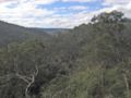
Looking north into the Mitchell River valley from The Bluff Lookout high above the Mitchell River National Park

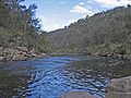
View upstream of the Mitchell River near the tributary de Woolshed Creek in Mitchell River National Park
View downstream of the Mitchell River near the tributary de Woolshed Creek in Mitchell River National Park


Inland delta
The Mitchell River delta is the classic shape of the inland delta and is considered one of the best examples in the world of this delta shape. The river flows along the west bank of Lake King to Eagle Point Bluff and then east straight into the lake.
At the mouth of the river , a river delta with alluvial silt deposits has formed, which form long sandbanks (“silt jetties”) that extend up to eight kilometers east into the lake. The silt has been deposited there for millions of years as the flow velocity decreases. These sandbars are classified by geologists as a formation of international standing, only surpassed by the sandbars of the Mississippi at its confluence with the Gulf of Mexico .
The sandbanks of the Mitchell River are exposed to increasing erosion due to the increasing salinity of the lake water , as this slowly causes the vegetation to die off. The establishment of a paved canal at Lakes Entrance in 1889 increased the salinity of the Gippsland Lakes. The destruction of reed populations, livestock ranching on the river banks, access for anglers and boat traffic are causing further erosion.
The marshland by the river is home to huge numbers of water birds, including waders from other parts of the world, and is used for education. The wetlands around the Gippsland Lakes are an important biotope covered by the Ramsar Convention .