
Mokrzeszów
| Mokrzeszów | |||
|---|---|---|---|
 Help on coat of arms |
|
||
| Basic data | |||
| State : | Poland | ||
| Voivodeship : | Lower Silesia | ||
| Powiat : | Świdnica | ||
| Gmina : | Świdnica | ||
| Geographic location : | 50 ° 51 ' N , 16 ° 22' E | ||
| Residents : | 1082 | ||
| Postal code : | 58-160 | ||
| Telephone code : | (+48) (+48) 74 | ||
| License plate : | DSW | ||
| Economy and Transport | |||
| Street : | Świdnica - Wrocław | ||
| Next international airport : | Wroclaw | ||


Mokrzeszów (German Kunzendorf near Freiburg ) is a village in the rural municipality Świdnica in the Powiat Świdnicki in the Lower Silesian Voivodeship in Poland .
location
Mokrzeszów is 9 km west of the district town Świdnica ( Schweidnitz ) on the road to Świebodzice ( Freiburg ).
history
The place was first mentioned in 1346 as a manor. In 1478, Nieder Kunzendorf owned Hans von Monau, who ceded it to his cousins Hans and Wenzel von Monau in 1488. In 1499 the estate belonged to Johann von Monau. In 1504 the owner was Heinz von Reder and in 1518 Hans von Reder. In 1548 Nieder Kunzendorf fell to Leonhard von Gellhorn. In the years 1568–1576 it was owned by his son Hans von Gellhorn, in 1619 by Joachim von Gellhorn, in 1621 by the brothers Leonhard and George von Gellhorn and in 1656 by Heinrich von Gellhom. In 1834 it became the property of the von Reder family. In 1880 the property fell to the Order of Malta who built a hospital on the site of the castle.
Since the 13th century Nieder Kunzendorf had its own church, which became Protestant during the Reformation and was returned to the Catholics in 1653. Kunzendorf was evangelically parish first to the Friedenskirche Schweidnitz and then to the Church of St. Peter and Paul in Freiburg. After the First Silesian War , Kunzendorf fell to Prussia and was incorporated into the Schweidnitz district. During the Seven Years' War , Friedrich II moved his headquarters to Kunzendorf in 1761.
1785 counted down Kunzendorf one parish and one school building, 1 Vorwerk , 21 peasants, 4 gardeners, cottagers and 21 315 inhabitants. Ober Kunzendorf had 1 farm, 1 school, 46 cottagers, 1 water mill and 1 windmill, 21 farmers, 6 gardeners and 371 residents.
In 1874 the administrative district of Kunzendorf was formed from the rural communities of Nieder Kunzendorf and Ober Kunzendorf and their manor districts . It was administered by the head of the office in Ober Kunzendorf. In 1913 Nieder Kunzendorf had 540 Protestant and 124 Catholic residents and Ober Kunzendorf had 674 Protestant and 38 Catholic residents. In 1939 Kunzendorf had a total of 1,357 inhabitants.
When it was taken over by Soviet troops and the Polish administration in 1945, Kunzendorf was renamed Mokrzeszów . The German residents were expelled and replaced by Poles .
Attractions
- Catholic parish church St. Hedwig, built in the 13th / 14th centuries Century, rebuilt around 1500 and 19./20. Century, Madonna around 1430, epitaph 16th century
- Hospital, formerly Nieder Kunzendorf Castle, built 1860–1880 in neo-Gothic style, 1918–1939 sanatorium, after 1945 agricultural and gardening school
gallery

Parish Church of St. Hedwig
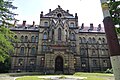
hospital

Medieval stone cross


Web links
Individual evidence
- ^ Johann G. Knie : Alphabetical-statistical-topographical overview of the villages, spots, cities and other places of the royal family. prussia. Province of Silesia: together with the attached evidence of the division of the country . Grass, Barth, 1845 ( google.de [accessed February 6, 2019]).
- ↑ Mokrzeszów. Retrieved February 6, 2019 .
- ^ Research on German history . Dieterich, 1877 ( google.de [accessed on February 6, 2019]).
- ^ Friedrich Albert Zimmermann: Contributions to the description of Silesia: Fifth volume . bey Johann Ernst Tramp, 1785 ( google.de [accessed on February 6, 2019]).
- ^ Kunzendorf district. Retrieved February 6, 2019 .
- ^ Kunzendorf (Schweidnitz district) - GenWiki. Retrieved February 6, 2019 .