
Molara (island)
| Molara | ||
|---|---|---|
 |
||
| Waters |
Gulf of Olbia ( Tyrrhenian Sea ) |
|
| Archipelago | Tavolara Archipelago | |
| Geographical location | 40 ° 52 '9 " N , 9 ° 43' 39" E | |
|
||
| length | 2.7 km | |
| width | 1.4 km | |
| surface | 3.411 km² | |
| Highest elevation | Punta la Guardia 158 m |
|
| Residents | uninhabited | |
 |
||

Molara is an island off the north east coast of Sardinia and, together with the other islands of the Tavolara archipelago and the Punta Coda Cavallo peninsula and the surrounding sea, has formed the Tavolara - Punta Coda Cavallo marine reserve since 1997 . The granite island covers an area of 3.411 km² with a coastline of around 10 km and rises with the Punta la Guardia up to 158 meters above sea level. d. M. The toponym , which can be proven from medieval times, is possibly derived from the regular, round shape of the island, which resembles a millstone ( Italian mola ). Molara has been inhabited since ancient times but was completely abandoned in the 20th century. The surrounding waters in the Gulf of Olbia are a popular destination for tourists.
geography
Molara is located around 2.5 km off the east coast of Sardinia, around two kilometers south of the neighboring island of Tavolara and two kilometers north of Cape Coda Cavallo. The closest town is Porto San Polo , but the island is part of the municipality of Olbia , the center of which is around 20 km northwest.
Molara is rounded in shape and made of the gray-pink granite of Gallura , which was formed during the Variscan orogeny in the late Paleozoic . The east and south-east coast (Punta Falcone, Punta Levante and Punta Scirocco) are rugged and rocky, sometimes with bizarre rock formations that were created by wind erosion . To the east of Cala di Chiesa , for example, the 'dinosaur rock' (scoglio del dinosauro) rises . Between the bays of Cala Chiesa on the north coast and Cala spagnola in the west, the coast is more accessible and has some stretches of beach where ice-age sand and sandstone occur.
Southwest of the island are the so-called piscine di Molara, a shallow water area shining turquoise due to white sand deposits on the bottom ( Aeolian sediment ), which is visited by tourists and sailors for snorkeling and swimming.
Two elevations characterize the topography: a chain of hills with Punta La Guardia as the highest elevation (158 meters above sea level) along the south coast of the island and Monte Castello ('castle hill') above the northwest coast, which rises 146 meters above the sea.

View from the north to Molara and Punta Coda Cavallo

Granite rocks over the south coast
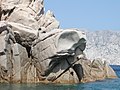
Rocky coast in the southeast
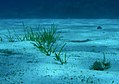
Seabed of the
Piscine di Molara


Flora and fauna
Although the island is rocky and impassable, there are freshwater springs that allowed people to colonize and cultivate grain, fruits, and vegetables.
The vegetation of Molara consists especially near the coast of a rich flora of Mediterranean macchia and is characterized by olive trees , mastic bushes and rock roses . A total of almost 400 plant species were registered on the island, plus around 80 different mosses . In the interior of the island there are also some cultivated plants owed by humans, whereby especially after the abandonment of the island by its operators in the middle of the 20th century, some species, especially grasses , have disappeared again.
The only mammals on the island were introduced by humans: Around 30 cattle and around 80 goats still live on the island - since around 2000 without human protection. The numerous rats , which regularly and completely destroyed the brood of the Mediterranean shearwater nesting on the island , were exterminated in 2008 by a program of the administration of the marine reserve. Ten reptile species have been counted on Molara, including several lizard and three turtle species, European leaf finger gecko , spotted roller skink and Italian ore crawl ; the only occurring species of snake is the yellow-green angry snake .
25 species of birds nest on the island, including three species that are considered endangered, in addition to the Mediterranean shearwater (2007 with around 300–600 breeding pairs, the largest colony in the Mediterranean area) nesting shag and coral gull (less than a hundred breeding pairs).
history
To date, no prehistoric settlement has been found on the island. It is identified with the buccina (Latin buccina, name of a purple snail ) described by Ptolemy . As a Sardinian name Salzai or Salsai is passed down. At the time of early Christianity , Pope Pontianus is said to have been exiled from Rome to this island in 235 together with Saint Hippolytus and both of them died here. The island therefore also appears on church maps as Insula Pontiana . In the north-western part of the island, near the bay of Cala Chiesa, there are the remains of a medieval, single-nave church in Romanesque style, which was dedicated to Saint Pontianus. This church, whose original title is unknown, is similar to other churches of this type in Gallura , such as San Leonardo in Balaiana near Luogosanto in the interior of the island. Around this church are the remains of a medieval settlement called Gurgurai or Gurguray. Somewhat higher up are the remains of a castle wall, the time of which is not fully established, but which was probably built between the 7th and 10th centuries to protect against Saracen attacks. There is evidence of a nunnery in the 15th century. Around the middle of the 19th century there were reports of "few inhabitants". In modern times the island was owned by the Tamponi family; Around the turn of the 20th century, the owners cultivated wheat, wine, persimmon trees , tomatoes, beans and watermelons and raised cattle, sheep and goats. The remains of this family's villa south of Punta la Guardia are still there. After the Second World War, the island was abandoned and the inhabitants left it for good; sheep and cows still live on the island and were looked after by a local family until around 2000.

See also
Web links
- Tavolara.it
- Website of the municipality of Olbia
- Portrait of the island on isoleitalia.it
- Web presence of the marine reserve Tavolara Punta Coda Cavallo (Italian / English)
Individual evidence
- ↑ a b c Emmanuele Bocchieri, Gianluca Iiriti: Flora and vegetation landscape of Molara island (north-eastern Sardinia), Cagliari (Lagascalia 25: 15-89) 2005; PDF online, 2.7 MB
- ↑ Alfreda Papurello: Gallura: una terra singolare, [ed.]: In Salvatore Brandanu: Sardegna: cultura e civiltà del Popolo gallurese, San Teodoro (Istituto delle Civiltà del Mare) 2001, pp 35-36; PDF online (2.1 MB)
- ^ A b c Giovanni Spano [Ed.]: Bullettino Archeologico Sardo ossia Raccolta dei monumenti antichi in ogni genere di tutta l'isola di Sardegna, 2nd year, Rome 1856, p. 75; PDF online, 1.2 MB
- ↑ Emmanuele Bocchieri, Gianluca Iiriti: Changes in land use and in the ruderal plant component as observed over the past 80 years on the Island of Molara (NE - Sardinia, Italy), Bocconea 21: pp. 167-173, 2007, ISSN 1120 -4060 , PDF online, 259 kB
- ↑ Augusto Navone and Spano: Rat eradication on Molara Island (MPA ofTavolara): experience feedback, presentation of the anti-rat program, 2009 PDF ( Memento of the original from February 16, 2016 in the Internet Archive ) Info: The archive link was inserted automatically and has not yet been checked. Please check the original and archive link according to the instructions and then remove this notice. online, 7.3 MB
- ↑ Alessandro Pirina: Molara, l'isola liberata dai topi, La Nuova, October 25, 2008
- ↑ Paolo Sposimo et al .: Rodent eradication on Molara Island and surrounding islets (NE Sardinia): from success to the riddle of reinvasion, in: Aliens: The Invasive Species Bulletin, Newsletter of the IUCN / SSC Invasive Species Specialist Group ISSN 1173- 5988 , Issue No. 32, 2012, pp. 33-38; PDF online, 6.4 MB
- ↑ Marco Borri et al .: Preliminary notes on the herpetofauna of the satellite islands of Sardinia, Boll. Soc. Sarda Sci. Nat., 26: 149-165, Florence 1988; PDF online, 3.9 MB
- ↑ Portrait of the marine reserve on www.parks.it
- ↑ Karen Bourgeois: YELKOUAN SHEARWATER Puffinus yelkouan. Updated state of knowledge and conservation of the nesting populations of the Small Mediterranean Islands, (Initiative PIM) 2012, PDF ( Memento of the original from May 21, 2016 in the Internet Archive ) Info: The archive link was inserted automatically and has not yet been checked. Please check the original and archive link according to the instructions and then remove this notice. , 1.1 MB
- ^ Consorzio the Gestione Area Marina Protetta di "Tavolara Punta Coda Cavallo", Rapporto finale 2007, Intervento B4 - Progetto Avifauna, Olbia 2007; PDF online, 2.2 MB
- ↑ Francesco Floris [Ed.]: La Grande Enciclopedia della Sardegna, Volume 5, Edizione speciale e aggiornata per La Nuova Sardegna, o. O. 2007, p. 146; PDF ( Memento of the original from May 26, 2012 in the Internet Archive ) Info: The archive link has been inserted automatically and has not yet been checked. Please check the original and archive link according to the instructions and then remove this notice. online, 5.4 MB
- ↑ Goffredo Casalis: Dizionario Geografico-Storico-Statistico-Commerciale Degli Stati Di SM Il Re di Sardegna, Turin 1840, digitized online
- ^ John Purdy: The coasts of Spain, France, and Italy, from Cape Trafalgar to Cape Spartivento; the Balearic Isles, Corsica, Sardinia, Sicily, and the Maltese Islands; with the African Coast from Tangier to Tripoli […], London 1840, p. 104; Digitized online