Mont Gargan
| Mont Gargan | ||
|---|---|---|
|
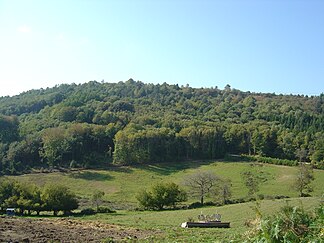
Mont Gargan, seen from the northeast from Saint-Gilles-les-Forêts |
||
| location | Haute-Vienne , (Central France ) | |
| part of | Massif Central | |
|
|
||
| Coordinates | 45 ° 37 ′ N , 1 ° 39 ′ E | |
| rock | Mica slate | |
The Mont Gargan , in Occitan Puèg Gerjant , is a summit of the French massif central . It is located on the western edge of the Plateau de Millevaches between the communes of Saint-Gilles-les-Forêts and Surdoux in the Haute-Vienne department ( Nouvelle-Aquitaine region ). It is an integral part of the Millevaches en Limousin Regional Nature Park in the Limousin .
geography
Mont Gargan is 38 kilometers southeast of Limoges (as the crow flies). It reaches a height of 731 meters above sea level (on older maps also 730 meters).
In a broader sense, Mont Gargan also refers to the entire massif that supports the summit. It dominates the upstream plateau du Limousin and the Monts de Fayat and can be seen as the westernmost branch of the Plateau de Millevaches . In good weather, all the hills of the Limousin can be made out from the summit (with panoramic information boards), including the Monts de Châlus , Monts de Blond , Monts d'Ambazac , Plateau de Millevaches and the Massif des Monédières . With very clear visibility even the Puy de Sancy and the Monts Dore can be seen. To the south, your gaze wanders over the Causses du Quercy and the hills of the Périgord noir .
In books and maps it is often said that Mont Gargan is the highest point in the Haute-Vienne department. But this is not correct - this honor is given to the Puy Lagarde , which is 25 kilometers further northeast and at Beaumont-du-Lac a little west of the Lac du Vassivière reaches a height of 795 meters.
Transport links
The D 39 runs east of Mont Gargan from Saint-Gilles-les-Forêts to Surdoux. A beech tree-lined avenue branches off from it and leads directly to the summit. The ruins of a chapel built between 1868 and 1871 stand on the summit.
geology
Mont Gargan is located on the crystalline basement of the northwestern Massif Central . It forms part of the parautochthonous vault of the Sussac Cathedral . This is built up by the tectonically deepest unit of the Limousin - the parautochthonous mica slate unit . The mica slate strikes mainly in a south-easterly direction, but can also turn in an easterly to north-easterly direction. They generally incline to the southwest, but the angles of incidence vary between 30 and 60 degrees. Stretch linear show an easterly to southeasterly direction. Almost 1 kilometer further south, the paragneiss of the pushed- off lower gneiss cover is already encountered near Surdoux .
ecology
The summit area was once completely overgrown with heather and gorse , but some of these have now had to give way to a meadow landscape. The original heather is still partially preserved and 80 hectares are designated as an ecological reserve (ZNIEFF type 1).
history
A memorial at the summit commemorates the Battle of Mont Gargan on July 24, 1944, in which a German division and hundreds of underground fighters of the Resistance faced each other under the command of Georges Guingouin .


