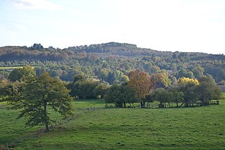
Monts de Fayat
| Monts de Fayat | |
|---|---|
|
The Monts de Fayat in the Massif Central |
|
|
The 534 meter high Puy de Bar |
|
| Highest peak | Puy de Bar ( 534 m ) |
| location | Haute-Vienne , (Central France ) |
| part of | Massif Central |
| Coordinates | 45 ° 35 ′ N , 1 ° 21 ′ E |
| rock | Metamorphites (orthogneiss, paragneiss, serpentinites) |
The Monts de Fayat are located in the south of the Haute-Vienne department in the Nouvelle-Aquitaine region , France . Geologically they belong to the north-western Massif Central .
etymology
The name Monts de Fayat goes back to the hamlet of the same name Fayat . The hamlet is just under 4 kilometers south of Château-Chervix . Fayat is likely derived from the Latin fagus (beech).
geography
The Monts de Fayat are located 28 kilometers south-southeast of Limoges (as the crow flies). They run roughly parallel to the northern edge of the Corrèze department , from which they are less than 10 kilometers away. They are separated on their east side from the Briance to Mont Gargan and the Plateau de Millevaches . The Monts de Châlus form its western border . The massif divides the Plateau du Limousin into two unequal halves. The larger northern part surrounds the Vienne valley in steps , the southern part is narrowed towards the southeast by the Vézère . Both halves of the plateau are connected to each other via a 480 meter high saddle at Masseret , which in turn is surmounted by the Monts de Fayat by another 50 meters.
The highest point in the Monts de Fayat is the Puy de Bar (also Puy de Barre ), located in the municipality of Château-Chervix , which reaches 534 meters above sea level. The high altitudes are forested and covered by the Forêt de Fayat .
The area of the Monts de Fayat extends over the following 6 municipalities:
- Meuzac
- Château-Chervix
- Coussac-Bonneval
- Saint-Priest-Ligoure
- La Roche-l'Abeille
- Saint-Yrieix-la-Perche .
In the east, the Monts de Fayat reach up to the foothills of the Plateau de Millevaches and reach Mont Gargan, to which they are occasionally also included.
geology
The Monts de Fayat lie entirely on the crystalline basement of the northwestern Massif Central . Structurally, they belong predominantly to the lower gneiss cover of the Limousin; the upper gneiss cover only appears on their northern edge . The pile of blankets lies more or less flat, but is gently folded with a wavelength of around 25 kilometers. Under the Monts de Fayat it forms the Meuzac-Antiklinorium with basal leucocratic orthogneiss (leptynites) in its core. Paragneiss and other leptynites have pushed themselves out of the higher lower gneiss cover over the orthogneiss core. At La Flotte and Le Cluzeau east of Château-Chervix, flat serpentinites also appear for the first time , which are tectonized remains of the former Limousin Ocean and which already represent the base of the upper gneiss cover. Amazingly, these pinched Ophiolites compared to the high grade amphibolite facies rocks of the gneiss ceiling only a relatively low metamorphic grade .
In orogenic late stage during the Upper Carboniferous smaller invaded Leukogranitkörper in the ceilings stack, such as Margnol and Violeizeix southwest of Château-Chervix. It is associated with smaller micro-granite tunnels that are mainly north-south oriented. When the area of brittle deformations was reached towards the end of the orogeny, a very close-knit network of north-east-south-west trending faults covered the pile of roofs, which subsequently silicified and mineralized. Mineralizations are gold , arsenic , antimony , tungsten , lead and zinc .
It is worth mentioning that there are eclogite deposits at Roche-l'Abeille and north of La Flotte .
Mining and raw materials
Gold was previously mined in the Monts de Fayat, as in other places in the vicinity of Saint-Yrieix-la-Perche (e.g. in the gold mines of Laurièras and La Fagassière ). The gold is found in north-north-east and east-north-east trending quartz veins , which, as already indicated, are linked to faults within the lower gneiss cover.
The richness of clay in the weathered basement became the basis for numerous brick factories . Also Kaolin was mined since the 18th century - Saint-Yrieix-la-Perche is known for its kaolin and was the oldest Kaolinlieferant in France.
literature
For the ceiling structure in the Limousin:
- Ledru, P. ua: Where are the nappes in the French Massif Central? In: Bulletin de la Société Géologique de France . tape 5 , 1989, pp. 605-618 .
For gold mineralization:
- Bouchot, V., Gros, Y. and Bonnemaison, M .: Structural controls on the auriferous shear zones of the Saint Yrieix district, Massif Central, France: evidence from the le Bourneix and Laurièras gold deposits . In: Economic Geology . tape 84 , 1989, pp. 1315-1327 .


