
Montane
|
Montane Gimelle |
||
.JPG) The Montane at Gimel-les-Cascades |
||
| Data | ||
| Water code | FR : P36-0430 | |
| location | France , Nouvelle-Aquitaine region | |
| River system | Dordogne | |
| Drain over | Saint-Bonnette → Corrèze → Vézère → Dordogne → Atlantic Ocean | |
| source | in the municipality of Saint-Yrieix-le-Déjalat 45 ° 26 ′ 30 ″ N , 1 ° 58 ′ 29 ″ E |
|
| Source height | approx. 710 m | |
| muzzle | on the municipal boundary of Tulle and Laguenne in the Saint-Bonnette coordinates: 45 ° 14 ′ 54 ″ N , 1 ° 46 ′ 6 ″ E 45 ° 14 ′ 54 ″ N , 1 ° 46 ′ 6 ″ E |
|
| Mouth height | approx. 205 m | |
| Height difference | approx. 505 m | |
| Bottom slope | approx. 13 ‰ | |
| length | 39 km | |
| Catchment area | 109 km² | |
| Outflow at the Laguenne gauge |
MQ |
4.09 m³ / s |
| Small towns | Grommet | |
The Montane is a river in France that runs in the Corrèze department in the Nouvelle-Aquitaine region . The river is named differently during its course: if it is still called Ruisseau de la Gane salée on the upper reaches, it will later become the Montane and finally the Gimelle in its mouth section .
It rises in the municipality of Saint-Yrieix-le-Déjalat , in the Regional Nature Park Millevaches en Limousin , generally drains in a south-westerly direction and after 39 kilometers on the municipal boundary of Tulle and Laguenne reaches the Saint-Bonnette as a right tributary , which in turn is about 500 meters further flows into the Corrèze .
Places on the river
ecology
The flow and the valley of Montane to Gimel-les-Cascades form an about 615-hectare nature reserve , and is in accordance with the ZNIEFF seal certified ( Z one n aturelle d ' i ntérêt é cologique, f aunistique et f loristique). Within this area there is a 130 hectare area that is protected in accordance with the Natura 2000 guidelines . This natural area also includes the nearby Étang de Ruffaud , whose outflow is a tributary of the Montane, which is also classified according to ZNIEFF.
Attractions
The waterfalls of Gimel-les-Cascades, with which the Montane plunges itself into the valley in three large jumps and one small one over a total of 143 meters. This waterfall has been classified as a natural monument in France since 1912.
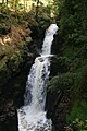
Gimel waterfall: the great fall - Grand Saut (45 m)
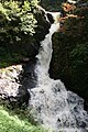
Gimel Waterfall: Second Fall - La Redole (27 m)
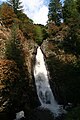
Gimel Waterfall: Third Fall - Queue de Cheval (60 m)


Web links
Individual evidence
- ↑ a b geoportail.fr (1: 16,000)
- ↑ a b c The information on the length of the river is based on the information about the Montane from SANDRE (French), accessed on July 22, 2011, rounded to full kilometers.
- ↑ Banque Hydro - Station P3674010 - la Montane à Laguenne (Synthèse) year 2010
- ↑ Archived copy ( Memento of the original dated December 4, 2008 in the Internet Archive ) Info: The archive link was inserted automatically and has not yet been checked. Please check the original and archive link according to the instructions and then remove this notice.
- ↑ https://inpn.mnhn.fr/site/natura2000/FR7401113
- ↑ Archived copy ( Memento of the original dated December 4, 2008 in the Internet Archive ) Info: The archive link was inserted automatically and has not yet been checked. Please check the original and archive link according to the instructions and then remove this notice.
- ↑ Archived copy ( memento of the original dated June 30, 2011 in the Internet Archive ) Info: The archive link was inserted automatically and has not yet been checked. Please check the original and archive link according to the instructions and then remove this notice.
- ↑ http://reisen.viamichelin.de/web/Reiseziel/Frankreich-Perigord_Dordogne/Sehenswurdheiten-Wasserfalle_von_Gimel_les_Cascades-E70 ( page no longer available , search in web archives ) Info: The link was automatically marked as defective. Please check the link according to the instructions and then remove this notice.