
Morganza Spillway


The Morganza Spillway is a hydraulic structure on the Mississippi River above Morganza on the west bank of the river in Louisiana . It is located on river mile 280, around 450 km above the Head of Passes in the southern area of Pointe Coupee Parish and is operated by the United States Army Corps of Engineers . The structure serves to lower the level of the river during floods and to channel the water past the cities of Baton Rouge and New Orleans during extreme flood events by diverting it into the Atchafalaya River and the Atchafalaya Basin . This is also intended to counter the potential danger that the Mississippi River will permanently change its course after a flood, which would have enormous ecological and economic consequences.
functionality
The Morganza Spillway is a controlled flood relief because it uses a series of lock gates to control the amount of water that can flow into the relief areas on either side of the structure. It consists of a weir made of reinforced concrete , two roller weirs, seventeen undermining indicators and 125 gates equipped with sluice gates with which around 17,000 m³ / s of water can be diverted from the Mississippi River. The structure was completed in 1954 and is maintained by the United States Army Corps of Engineers. In the event of flooding, it is checked that the foundations are not undermined and unstable. The US Highway 190 crosses the discharge channel on a roughly seven-kilometer bridge. An older two-lane bridge runs directly over the structure and forms part of Louisiana Highway 1 .
Operation during high water
Both sides of the Morganza Spillway are usually above normal water levels and are therefore usually dry. In order for the water to be diverted through the relief channel, the water level in the Mississippi River must exceed the high water mark. The Corps of Engineers is considering opening the Morganza Spillway if the Mississippi River runoff at Red River Landing , Louisiana exceeds 1,500,000 cubic feet (approximately 42,000 m³ / s) and continues to rise.
Since 1963, water has usually only been diverted from the Mississippi River at one point during floods, at the Old River Control Structure (ORCS), where normally 30% of the flow is diverted into the Atchafalaya River. During the Mississippi flood in 1973, this structure was damaged due to the high flow rate, so that the Morganza Spillway was also opened to relieve the Old River Control Structure, later the Army Corps built the Old River Control Auxiliary Structure (ORCAS) directly below the ORCS, so In the event of extreme floods, additional flood gates enabled the water to drain away .
The Morganza Spillway, located approximately 50 km downriver from ORCS and ORCAS, was built to channel additional water from the Mississippi River into the Morganza Floodway, which continues down into the Atchafalaya Floodway before the combined water from both relief canals enters the Gulf of Mexico flows. In the event of an extreme flood event, the flood can also drain through the Atchafalaya Basin. The discharge of the water from the main arm of the river leads to a lowering of the water level in the Mississippi River below the structure and reduces the pressure on the levees and other structures for flood protection below and above the two systems. The flood relief at Morganza is also intended to prevent the Mississippi River from changing its course permanently and flowing over the Atchafalaya River to the Gulf of Mexico away from Baton Rouge and New Orleans.
The water passing the Morganza Spillway first enters the relief polder , which extends from the levees on the Mississippi River to the eastern levees on the Atchafalaya River. The polder has a length of around 30 km and a width of up to eight kilometers. This includes a stilling basin, an inlet channel, an outlet channel and two dykes that separate the polder from the surrounding area. The diverted water reaches the Atchafalaya River Basin Floodway near Krotz Springs .
When water is drained from the high-water Mississippi River into the Morganza Floodway and thus into the Atchafalaya Basin, a large area of southern Louisiana is flooded. For this reason, the weir is only relieved if there is flooding in the areas below the relief polder, regardless of whether the weir is opened or not. This “natural” flooding and the amount of water diverted determine the extent of the flood in the Atchafalaya Basin. Are endangered Morgan City , several other smaller settlements, many farms and vast wetlands. The residents know that the region is a natural floodplain and every year all those affected are reminded in writing that the flood relief system can be operated. Any decision to open the weir must be carefully planned so that those affected can be warned and their lives and property can be brought to safety. Part of this planning process is the creation of scenarios by the Army Corps of Engineers that will allow those affected to discuss how much, if any, water should be diverted from the Mississippi River.
Past flood events
The Morganza Spillway was first opened in 1973: this was done to relieve water pressure on the Old River Control Structure. The lock gates were opened in such a way that the flood discharge absorbed about half of its planned maximum flow rate. The structure was slightly undermined and there was minor damage to the stilling basin. The Atchafalaya Basin was partially flooded. After the flood disaster of 1973, the structure was repaired again.
In 2008, the top of a flood on the Mississippi River was higher than the levees near the Morganza Spillway, but it was not opened. Residents and United States National Guard soldiers attempted to raise the levees with sandbags , but additional rainfall caused the flood to wash over the sandbags and the flood inundated 1,200 acres of farmland within the relief canal.
Flood disaster 2011
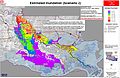
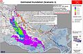
Before May 13, 2011, the Army Corps of Engineers considered four scenarios, all four of which assumed that Bonnet Carré Spillway near New Orleans would be fully opened.
- Scenario 1: Morganza Spillway is half opened so that 8500 m³ / s would be diverted
- Scenario 1A: like # 1, but Morganza Spillway would only be opened to 25 percent, so that 4200 m³ / s would be discharged
- Scenario 2: Morganza Spillway remains closed and the flow rate from the Mississippi River to the Atchafalaya River is limited to 30 percent at the Old River Control Structure
- Scenario 3: like # 2, but an additional 4200 m³ / s are derived from the Old River Control Structure

Scenario 1

Scenario 1a
Scenario 2
Scenario 3


The analyzes showed that the Atchafalaya Basin will definitely be flooded, regardless of whether the Morganza Spillway is opened or not. On May 13, 2011, the Army Corps of Engineers decided to open the Morganza Spillway to 25 percent of its capacity, using scenario 1A.
literature
- John McPhee : The Control of Nature
Web links
supporting documents
- ↑ a b c d e f g h i Morganza Floodway ( English ) United States Army Corps of Engineers. Archived from the original on January 11, 2012. Info: The archive link was inserted automatically and has not yet been checked. Please check the original and archive link according to the instructions and then remove this notice. Retrieved May 12, 2011.
- ↑ a b c Louisiana OLD RIVER CONTROL STRUCTURE and Mississippi river flood protection ( English ) In: America's Wetland Resource Center . Loyola University's Center for Environmental Communication (LUCEC). Retrieved May 12, 2011.
- ↑ a b c d John A. Weeks: Morganza Floodway ( English ) Retrieved May 12, 2011.
- ↑ a b c Will the Mississippi River change its course in 2011 to the red line? ( English ) mapping support. Retrieved May 12, 2011.
- ^ Ronald Joel Daniels: On Risk and Disaster: Lessons from Hurricane Katrina ( English ). University of Pennsylvania Press, 2006, p. 44.
- ↑ Mark Schliefstein: Record high river likely to require opening of Morganza Spillway next week ( English ) The Times-Picayune (New Orleans). May 4, 2011. Retrieved May 12, 2011.
- ↑ Mark Schliefstein: Morganza Spillway might be opened to ease swollen Mississippi River ( English ) The Times-Picayune (New Orleans). May 8, 2011. Retrieved May 12, 2011.
- ↑ Mike Hasten: Morganza Spillway expected to open soon (English) , The News Star. May 9, 2011. Retrieved May 12, 2011.
- ↑ Gov. Jindal Asks Army Corps to Release Map Outlining Impact of Possible Opening of Morganza Spillway, Says State Continues to Prepare for Flooding (English) , Baton Rouge Today. May 6, 2011. Archived from the original on September 10, 2011 Info: The archive link was inserted automatically and has not yet been checked. Please check the original and archive link according to the instructions and then remove this notice. . Retrieved May 12, 2011.
- ↑ a b Corps Releases Inundation Map ( English ) United States Army Corps of Engineers. July 11, 2011. Archived from the original on July 29, 2011. Info: The archive link was automatically inserted and not yet checked. Please check the original and archive link according to the instructions and then remove this notice. Retrieved May 12, 2011.
- ↑ Water Over the Levee in Louisiana: 3,000 acres of wheat acres hurt ( English ) Midsouth Farmer. April 8, 2008. Archived from the original on August 21, 2011. Info: The archive link was automatically inserted and not yet checked. Please check the original and archive link according to the instructions and then remove this notice. Retrieved May 12, 2011.
- ↑ a b The Mississippi River . United States Army Corps of Engineers. May 9, 2011. Archived from the original on May 9, 2011. Info: The archive link was automatically inserted and not yet checked. Please check the original and archive link according to the instructions and then remove this notice. Retrieved May 12, 2011.
- ↑ Morganza Spillway to open Saturday (English) , WAFB TV. May 13, 2011.
Coordinates: 30 ° 46 ′ 38.7 " N , 91 ° 37 ′ 11.4" W.