Morge (Lake Geneva)
| Morning | ||
|
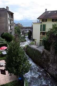
The morning in Saint-Gingolph between F (left) and CH (right) |
||
| Data | ||
| Water code | FR : V0300500 , CH : 3909 | |
| location | France , Auvergne-Rhône-Alpes region and Switzerland , Canton of Valais | |
| River system | Rhône | |
| Drain over | Rhône → Mediterranean | |
| source | in the municipality of Bernex (FR) 46 ° 21 ′ 0 ″ N , 6 ° 46 ′ 20 ″ E |
|
| Source height | approx. 1714 m | |
| muzzle | between Saint-Gingolph (CH) and Saint-Gingolph (FR) in Lake Geneva Coordinates: 46 ° 23 ′ 39 ″ N , 6 ° 48 ′ 19 ″ E ; CH1903: 551282 / 138 289 46 ° 23 '39 " N , 6 ° 48' 19" O |
|
| Mouth height | 373 m | |
| Height difference | approx. 1341 m | |
| Bottom slope | approx. 17% | |
| length | 7.9 km | |
| Catchment area | approx. 19 km² | |
The Morge (also Morge de Saint-Gingolph ) is a 7.9 km long tributary of Lake Geneva , which in the French department of Haute-Savoie in the region of Auvergne Rhône-Alpes springs and then the border to the Swiss canton of Valais forms. It should not be confused with the river of the same name , which flows into the Rhone at Conthey and with the Morges , which flows into Lake Geneva near Morges in the canton of Vaud .
course
The Morge, which is still called l'Eau des Rasses here , rises on the southern slope of the Pic Boré ( 1974 m ) below the Col de Neuva ( 1775 m ) just in the area of the municipality of Bernex on French territory. It flows eastwards first and takes on its most important tributary at the hamlet of La Planche (F), which rises on the northern slope of the Dent du Vélan ( 2059 m above sea level ) and forms the border with Switzerland up to its confluence. The Morge, which itself now forms the border to the mouth, flows in a north-easterly direction and crosses a wooded area. It affects the center of Novel (F) and the hamlets of Clarive and Frenay (both CH). Here it forms a narrow, wooded valley and then flows into Lake Geneva between Saint-Gingolph (F) and Saint-Gingolph (CH) .
See also
Individual evidence
- ↑ Source geoportail.gouv.fr
- ↑ estuary geoportail.gouv.fr
- ↑ Water information system Service d'Administration National des Données et Référentiels sur l'Eau (French) ( information ), accessed on August 16, 2014.
- ^ Geoserver of the Swiss Federal Administration.
