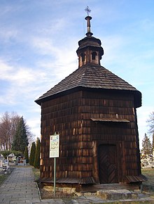
Moszczenica (Powiat Gorlicki)
| Moszczenica | ||
|---|---|---|
 Help on coat of arms |
|
|
| Basic data | ||
| State : | Poland | |
| Voivodeship : | Lesser Poland | |
| Powiat : | Gorlice | |
| Gmina : | Moszczenica | |
| Geographic location : | 49 ° 43 ' N , 21 ° 7' E | |
| Height : | 290 m npm | |
| Residents : | 3390 (March 31, 2011) | |
| Postal code : | 38-321 | |
| Telephone code : | (+48) 13 | |
| License plate : | KGR | |
Moszczenica is a village and seat of the municipality of Moszczenica in the Powiat Gorlicki in the Lesser Poland Voivodeship in Poland .
geography
The place is located on the Moszczanka brook in the Ciężkowice Mountains . The neighboring towns are Staszkówka and Turza in the northwest, Sitnica in the northeast, Bugaj, Kwiatonowice and Zagórzany in the east, Mszanka in the south and Łużna in the west.
history
The place on the river of the same name ( in fluvio, qui Mosczenycza dicitur ) was founded according to the founding privilege of King Casimir the Great in 1348 under German law by the locator Jan Herbert on 80 Franconian hooves . The founding privilege spoke about the repeal of Polish law, so there was an older settlement on traditional Polish law. The name Moszczenica is derived either topographically (moszennica - Coluteocarpus bris ) or from the word most (bridge). Later, Moszczenica was mentioned as two places: Moszczenica Polska (literally Polish , later Moszczenica Dolna, literally Nieder, creek downstream) and Moszczenica Niemiecka (literally German , later Moszczenica Górna - Ober [up]).
The first Roman Catholic wooden church, 12 m long, 6 to 7 wide, with 3 naves , was built in the middle of the 14th century.
In 1393 the mayor in Moschnicz was a certain Lupold (Lewpoldus) , then Marcisz Wrocimowic .
The place initially belonged to the Kingdom of Poland (from 1569 in the aristocratic republic of Poland-Lithuania ), Krakow Voivodeship , Biecz district , and around 1600 the village of Moszczenica Niemiecka (Górna) was one of the largest in the district with over 400 inhabitants. During the first partition of Poland , Moszczenica came to the new Kingdom of Galicia and Lodomeria of the Habsburg Empire in 1772 (from 1804). From 1855 Moszczenica belonged to the Gorlice District .
In 1918, after the end of the First World War and the collapse of the Austro-Hungarian monarchy, Moszczenica came to Poland. This was only interrupted by the occupation of Poland by the Wehrmacht in World War II . From 1975 to 1998 Moszczenica was part of the Krosno Voivodeship .
Personalities
- Leon Wałęga (1859–1933), Roman Catholic clergyman, Bishop of Tarnów
Web links
Individual evidence
- ↑ a b c Andrzej Matuszczyk: Pogórze Karpackie . Oddział PTTK "Ziemi Tarnowskiej", Tarnów 1995, ISBN 83-903260-1-9 , p. 286 (Polish).
- ^ CIS 2011: Ludność w miejscowościach statystycznych według ekonomicznych grup wieku , March 31, 2011, accessed on April 19, 2019 (Polish).
- ↑ a b c Tomasz Jurek (editor): MOSZCZENICA NIEMIECKA, WYŻNA lub WIELKA ( pl ) In: Słownik Historyczno-Geograficzny Ziem Polskich w Średniowieczu. Edycja elektroniczna . PAN . 2010-2016. Retrieved April 22, 2019.
- ↑ Władysław Lubas: nazwy miejscowe Południowej części dawnego województwa Krakowskiego . Polska Akademia Nauk . Instytut Języka Polskiego, Wrocław 1968, p. 97 (Polish, online ).
- ↑ Tomasz Jurek (editor): MOSZCZENICA POLSKA, NIŻNA lub MAŁA ( pl ) In: Słownik Historyczno-Geograficzny Ziem Polskich w Średniowieczu. Edycja elektroniczna . PAN . 2010-2016. Retrieved April 22, 2019.
- ↑ Moszczenica: ludzkie szczątki i fundamenty kościoła
- ^ Henryk Rutkowski (editor), Krzysztof Chłapkowski: Województwo krakowskie w drugiej połowie XVI wieku; Cz. 2, Komentarz, indeksy . Institute of History of the Polish Academy of Sciences, 2008, p. 78 (Polish, online ).

