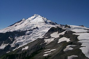
Mount Baker
| Mount Baker | ||
|---|---|---|
|
Mount Baker as seen from the northeast |
||
| height | 3286 m | |
| location | State Washington , USA | |
| Mountains | Cascade chain | |
| Coordinates | 48 ° 46 '12 " N , 121 ° 48' 59" W | |
|
|
||
| Type | Stratovolcano | |
| Age of the rock | approx. 30,000 years | |
| Last eruption | 1880 | |
| First ascent | 1868 by Edmund T. Coleman and companions | |
Mount Baker is a 3286 m high stratovolcano with an ice-covered peak in the mountain range of the Cascade Range in Washington ( Whatcom County ). It is located about 50 km east of Bellingham and is only 64 km from the Canadian metropolis of Vancouver . The volcano was called "Koma Kulshan" (German, white, steep mountain ) by the Nooksack tribes . It received its official name from Lieutenant Joseph Baker, who was the first European to sight the mountain on April 30, 1792 on board the HMS Discovery under the command of George Vancouver .
After Mount Rainier , Mount Baker is the most glacier- covered volcano in the Cascade Mountains : The volume of snow and ice is 1.8 km³ and is therefore larger than that of all volcanoes in the mountain range combined (with the exception of Mount Rainier). It is also one of the mountains with the most snowfall worldwide: In 1999 it set the (unofficial) world record for the most snowfall in one season (2855 cm).
The mountain is about 30,000 years old but rests on the flank of the extinct and eroded Black Buttes volcano , which was active about 500,000 to 300,000 years ago . The last eruptions of Mount Baker took place in the middle of the 19th century. In the late 1950s, numerous small-volume attachments were made . In the early 1970s, a cloud of steam or smoke appeared and the dam below the summit was emptied as a precautionary measure to prevent possible flooding of the city of Everett .
The mountain and its surroundings are popular with climbers, mountaineers, hikers, snowmobilers , skiers , campers and much more. The normal route for climbing the mountain leads over the Easton Glacier . It usually takes two days for him.
The ski area is located below Artist Point, where several meters of snow fall per year due to its proximity to the temperate rainforest of the Pacific northwest coast .
See also
Individual evidence
Web links
- Mount Baker in the Global Volcanism Program of the Smithsonian Institution (English)


