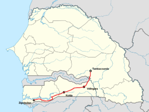
N 6 (Senegal)
| N 6 in Senegal | ||||||||||||||||||||||||||||||||||
| map | ||||||||||||||||||||||||||||||||||
| Basic data | ||||||||||||||||||||||||||||||||||
| Operator: |
|
|||||||||||||||||||||||||||||||||
| Start of the street: | south of Tambacounda , junction from the N 7 | |||||||||||||||||||||||||||||||||
| End of street: | Ziguinchor , confluence with the N 4 | |||||||||||||||||||||||||||||||||
| Overall length: | 401 km | |||||||||||||||||||||||||||||||||
| Requirement for use: | no | |||||||||||||||||||||||||||||||||
|
Course of the road
|
||||||||||||||||||||||||||||||||||
The N 6 is one of the national roads in southern Senegal .
The course of the road begins on the southern edge of the city of Tambacounda , which is an important traffic junction in the east of Senegal , at a junction from the N 7 , very close to Tambacounda Airport . The end of the N6 is in the southwest in Ziguinchor , where it joins the N 4 in the city center and the route up to then is 401 kilometers long.
The road is an east-west connection from the heartland of Senegal to the fertile and relatively densely populated landscape of Casamance, which is isolated south of Gambia . It leads through the regions (from east to west) Tambacounda , Kolda , Sédhiou , and Ziguinchor .
Since the Casamance is separated from the rest of Senegal by the Gambia and its southern tributary Koulountou , two year-round water-bearing rivers, a road into the Casamance required a 160-meter-long bridge over the Gambia valley. Thus the bridge of the N6 is the only inland land connection in this part of Senegal. A few kilometers behind the bridge, in Manda Douane , an 85-kilometer-long, well-developed regional road branches off to the south and leads via Médina Gounass to Koundara in Guinea-Conakry to the most important border crossing into this neighboring country. To the west of Kolda, the N6 runs through the strip of land, which is only eight to thirteen kilometers wide, between the left southern bank of the Casamance River and the border with Guinea-Bissau . Although it only opens up a small area of the Casamance for long-distance traffic, it is by far the largest city in southern Senegal with Ziguinchor .
