Nagarjuna Sagar Dam
| Nagarjuna Sagar Dam | |||||||||
|---|---|---|---|---|---|---|---|---|---|
| Nagarjuna Sagar Dam | |||||||||
|
|||||||||
|
|
|||||||||
| Coordinates | 16 ° 34 '36 " N , 79 ° 18' 44" E | ||||||||
| Data on the structure | |||||||||
| Lock type: | Gravity dam , earthfill dam | ||||||||
| Construction time: | 1955-1974 | ||||||||
| Height above foundation level : | 124.66 m | ||||||||
| Building volume: | 7.725 million m³ | ||||||||
| Crown length: | 4864 m | ||||||||
| Power plant output: | 815.6 MW | ||||||||
| Data on the reservoir | |||||||||
| Water surface | 198-285 km² | ||||||||
| Storage space | 11,561 million m³ | ||||||||
| Total storage space : | 5,733 million m³ | ||||||||
| Catchment area | 215,000 km² | ||||||||
| Design flood : | 42 476 m³ / s | ||||||||
| Nagarjuna Sagar Reservoir | |||||||||
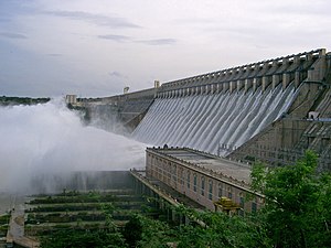
The Nagarjuna-Sagar Dam is a large dam in India .
It is located between the cities of Guntur and Hyderabad on the Krishna , on the border of the Guntur district in the state of Telangana and the district of Nalgonda in the state of Andhra Pradesh . It was one of the first modern hydropower projects in India. The Nagarjuna dam was completed in 1969, is 124 m high, 1 km long and has 26 locks on the crown. It is said to be the largest masonry dam in the world.
Reservoir
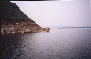
The artificial lake is with its memory space of around 11,500 million the largest in India, but around the world - both for storage space as well as on the water surface - the data available from 11,315 not vary among the largest 100. For the storage space over 11,472 and 11,500 to 11,561 million cubic meters.
Lately the inflows to the reservoir have decreased because there are now an increasing number of other projects above.
prehistory
The Krishna River is one of the longest rivers in India and has its source in Mahabaleshwar in Maharashtra , flows through Sangli and flows into the Bay of Bengal at Hamasaladeevi in Andhra Pradesh . The state of Andhra Pradesh could not use the river effectively until the middle of the 20th century because there was no reservoir to store the water. On the one hand, floods devastated the villages in the Krishna district , while on the other hand, the Nalgonda and Gunturu districts could not use the excess water.
The plan to build a dam to use the river's excess water was promoted by the British rulers in 1903. Siddeswaram and Pulichintala were found as possible locations for a reservoir, but none of these proposals were implemented.
Based on the 1952 report of the Khosla Committee, the government, led by Jawaharlal Nehru , decided to build reservoirs in arid regions as part of India's first five-year plan . State governments were asked to identify possible locations for such projects. After Andhra Pradesh was founded in 1953 and its government made such a statement, the foundation stone for the Nagarjuna-Sagar Dam was laid on December 10, 1955 . It was named after the Buddhist monk Nagarjuna .
Construction work
Construction began in February 1956, but there was no modern equipment due to a lack of funds. The dam was therefore built from masonry instead of concrete. A cement factory was built for the construction project at Macherla . A railway line was also built between the construction site and the cement factory. The stones came from the nearby Sunkesula quarries, sand from the Rayavaram and Halia rivers . The Buddhist monuments and other historical artifacts in the area have been moved or kept in the Nagarjuna Konda Museum. In 1967 the dam was inaugurated by Prime Minister Indira Gandhi . The construction of the dam was completed in 1969. The dam was fully usable in 1972 after the crown locks were fitted. Total expenses including maintenance up to 2005 were 1300 crore (13 billion) rupees. The number of construction workers involved in the project varied between 45,000 and 70,000. Approximately 174 people were killed in accidents during construction. 52 villages disappeared in the water and 24,000 people had to resettle. The resettlements lasted until 1967.
Benefit of the project
The dam supplies the districts of Nalgonda , Prakasam , Khammam , Krishna and Gunturu with irrigation water. Two canals - right and left - were built to divert the water from the reservoir for supply. The right canal (Jawahar Canal) is 203 km long and irrigates 4500 km² of land. The left channel (Lalbahadur-Shastri-Kanal) is 295 km long and irrigates 4200 km².
Hydropower
The hydropower plant has a power generation capacity of 815.6 MW. A power plant with 90 MW is added on the right channel and one with 60 MW on the left channel. (after Andhra Pradesh Hydel Power Plants )
Further data
(according to Nagarjuna Sagar Project Brief Profile )
- Masonry dam:
- Overflow length of the dam = width of the flood discharge : 471 m
- Length of the dam wall that cannot be overflown: 979 m
- Total length of the dam wall: 1450 m
- Maximum height of the dam wall: 125 m (the wall height is 124 or 125 meters according to different information)
-
Earth dam :
- Total length of the earth dam: 3414 m
- Maximum height of the earth dam: 26 m
Total length of the structure: 4864 m
See also
- List of the largest dams on earth
- List of the largest reservoirs on earth
- List of the largest hydroelectric plants in the world
- List of dams in the world # India
Web links
- Article about the dam in The Hindu
- Nalgonda District Tourist Opportunities ( Nalgonda District Tourist Opportunities )
Individual evidence
- ↑ National Register of Large Dams (PDF 9.3 MB) Central Water Commission. Archived from the original on August 20, 2014. Info: The archive link was inserted automatically and has not yet been checked. Please check the original and archive link according to the instructions and then remove this notice. Retrieved April 22, 2016.
- ↑ Andhra Pradesh Hydel Power Plants
- ↑ Nagarjuna Sagar Project Brief Profile ( Memento of the original from February 10, 2007 in the Internet Archive ) Info: The archive link was inserted automatically and has not yet been checked. Please check the original and archive link according to the instructions and then remove this notice.


