Nahehöhenweg
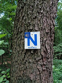
The Nahehöhenweg is a 108-kilometer hiking trail that leads from Neubrücke near Birkenfeld to Bingen am Rhein . In the upper part it partly follows the course of the Nahe , but in Bad Sobernheim it leaves the Nahe valley and leads to Bingen above the western banks of the Nahe through the southern Hunsrück and Soonwald . In its course it crosses the German states of Saarland and Rhineland-Palatinate . In Saarland the route is looked after by the Saarwald Association , in Rhineland-Palatinate by the Hunsrück Association . Is marked near the trail with a N .
Naheweg
The Nahehöhenweg is connected to the 75-kilometer Naheweg , which leads from the Rastpfuhl in Saarbrücken through the Saarkohlenwald and then on via Göttelborn , Illingen and Urexweiler down to the valley of the Blies near Gronig and further into the Nahe valley. The Nahe spring near Selbach can be reached with a detour of 2.5 km in length. In the further course the places Gonnesweiler and Türkismühle are hiked through, and at Nohfelden the path leaves the Saarland. From here the path is called Nahehöhenweg .
Further course
In Rhineland-Palatinate, the Nahehöhenweg runs from Neubrücke, south of Birkenfeld, initially on the heights north above the Nahe to Kronweiler . From there it leads along the shore to Idar-Oberstein . It continues on the Nahe river bank and crosses the towns of Fischbach - Kirn-Sulzbach and Kirn , partly near the federal highway 41 . From Kirn the path leaves the Nahe and leads through the Kellenbachtal to the heights north of the Nahe, later through vineyards to Bad Sobernheim. Here we leave the Nahe valley again and the path runs through the southern foothills of the Hunsrück and the Soonwald . On this section, the towns of Burgsponheim , Braunweiler , Dalberg and finally Spabrücken are reached. The last stretch to Bingen leads through the Binger Forest and touches the towns of Stromberg , Warmsroth , and the Steckeschläfer-Klamm sight down to Bingen.
Literature and map
- Günter Schmitt: The Saar - From the source to the mouth , PVS Edition, ISBN 3-9805454-4-X
- Hiking map Saarland 1: 75,000, RV Verlag Stuttgart, ISBN 3-575-11159-6
- Kay Sendelbach: The Nahehöhenweg: From Neubrücke to Bingen am Rhein , Verlag fernwege.de 2006, ISBN 3-937304-66-5
- Landesvermessungsamt Rhineland-Palatinate, hiking maps 1: 50,000, Saar-Hunsrück Nature Park , ISBN 3-89637-306-4 , Soonwald-Nahe Nature Park , ISBN 3-89637-300-5

