
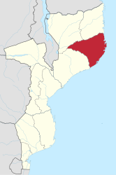
Nampula Province
| Nampula | |
|---|---|
  |
|
| Basic data | |
| Country | Mozambique |
| surface | 81,606 km² |
| Residents | 6,102,867 (2017 census) |
| density | 75 inhabitants per km² |
| ISO 3166-2 | MZ-N |
| Website | nampula.gov.mz (Portuguese) |
Coordinates: 15 ° 10 ′ S , 39 ° 7 ′ E
The province of Nampula is located in the east of Mozambique . It has an area of around 81,606 km². About six million people live in this area.
The capital of the province of Nampula is the city of Nampula with about 303,346 inhabitants.
population
The population of the province rose from 2.4 million in the 1980 census to 6.1 million in the 2017 census, making Nambula the most populous province in Mozambique.
| Census year | population |
|---|---|
| 1980 | 2,402,700 |
| 1990 | 3,063,456 |
| 2007 | 3,985,613 |
| 2017 | 6,102,867 |
Society and economy
The province is mainly inhabited by Makua . In addition to traditional agriculture and subsistence farming, mainly pineapples, bananas, cotton, cashews, corn, mangoes and tobacco are produced in larger farms.
Ilha de Moçambique
The island of Ilha de Moçambique belongs to this province . It was declared a World Heritage Site by UNESCO in 1992 . The course of 15 years of civil war and its effects destroyed a hitherto unique coexistence of many cultures on this island and triggered considerable refugee movements.
Administrative structure
The province of Nampula is divided into 18 districts :
- Angoche
- Eráti
- Lalaua
- Malema
- Meconta
- Mecubúri
- Memba
- Mogincual
- Mogovolas
- Moma
- Monapo
- Mossuril
- Muecate
- Murrupula
- Nacala-a-Velha
- Nacarôa
- Nampula
- Ribauè
literature
- Manfred Kuder: Mocambique, a geographical, social and economic country studies , scientific country customers, volume 10
Web links
- Portal do Governo da Província de Nampula on www.nampula.gov.mz (Portuguese)
- Ministério da Administração Estatal: Perfis dos Distritos. on www.nampula.gov.mz (Portuguese)
Provinces: Cabo Delgado | Gaza | Inhambane | Manica | Maputo | Maputo (city) | Nampula | Niassa | Sofala | Tete | Zambezia
Districts: see List of Districts of Mozambique
Postos administrativos: see list of Postos administrativos in Mozambique