Nanos
| Nanos | |
|---|---|
|
Location of the Nanos mountain range |
|
|
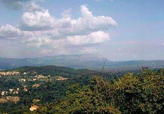
Nanos seen from the Monrupino / Repentabor church |
|
| Highest peak | Suhi Vrh ( 1313 m. I. J. ) |
| location | Goriška / Notranjsko-kraška , Slovenia |
| part of | Karst / Southern Alps |
| Coordinates | 45 ° 50 ′ N , 14 ° 2 ′ E |
| rock | limestone |
Nanos is a low mountain range on the south-eastern edge of the Julian Alps or the northern edge of the Karst in southwest Slovenia , between Postojna and Trieste , its highest point at 1313 m is the Suhi Vrh .
geography
The eastern edge of the karst plateau drops steeply from Pleša (1262 m) to Razdrto , to the west the mountain range gradually descends to 500 m. In the northeast it borders on the ridge of the Birnbaumer Forest (Hrušica).
Together with the Birnbaum forest, the Schwarzenberg plateau (Črni vrh), the hinterland of the Hubelj river, the western parts of the Ternovski forest (Trnovski gozd) and Banjšiče, it forms a hydrogeological unit whose karst water body is determined by Mesozoic Dachstein limestone and limestone breccias . These form highly porous karst aquifers with high hydraulic conductivity. These are all deep karsts . The karst aquifer is bounded on three sides by Nanos and the Birnbaumer Wald by Flysch and borders the Predjama Fault in the northeast. The area forms an important watershed between the catchment areas of the Adriatic and Danube (see watersheds in the Alps ).
Climatically, the Nanos ridge lies on the border between the moderate continental climate and the inland-sub-Mediterranean climate of the Wippach Valley. The area is one of the wettest regions in Slovenia (up to over 2000 mm). The vegetation of the sparsely populated region is part of the Dinaric fir-beech forest .
In ancient times, the Nanos and the surrounding regions were called the Okra Mountains. According to the Greek geographer Strabon , the Celtic - Illyrian tribe of the Iapods settled here . In Roman times, the Nanos was on the border between Italy and the province of Pannonia .
Transmitter
Since 1953 there has been a transmitter of the Slovenian radio for radio and television on the Pleša . Two transmission towers 52 and 35 meters high serve as antenna supports. During the 10-day war , the station was bombed by the Yugoslav Air Force on June 28, 1991 .
The Vojkova mountain hut (Vojkova koča), which can also be reached via a road, is located near the transmitter.
Jeronimos Church
The church is located on a small plain below the secondary peak Grmada at an altitude of 1019 m, about half an hour from the Vojkova hut. A shrine of St. Jerome was here as early as the 14th century. The church probably got its present size and shape at the end of the 16th or in the first quarter of the 17th century. It was later abandoned and fell into disrepair, but was re-consecrated in 1990. The two-column marble altar was erected when the church was being renovated. The carved, gilded altar is worth seeing.
According to oral tradition, seafarers from Trieste used to donate around 280 liters of oil annually in earlier centuries to illuminate the church at night as a guide for navigation.
photos
Pleša from the direction of Razdrto
View from the Pleša to Razdrto
View from Nanos to the Birnbaumer Forest (Hrušica)
Web links
Individual evidence
- ↑ a b Alps after the traditional border at the Adelsberger gate .
- ^ Description of the Hieronymus Church on slovenia.info, accessed on August 11, 2014.


