Marojejy National Park
|
Marojejy National Park
|
||
| location | Antsiranana , Madagascar | |
| surface | 597.52 km² | |
| WDPA ID | 2305 | |
| Geographical location | 14 ° 26 ′ S , 49 ° 44 ′ E | |
|
|
||
| Setup date | 1952 | |
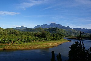
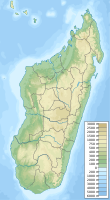
The Marojejy National Park ( French Parc Nacional Marojejy ) is a 597.52 km² protected area in Madagascar , which was designated in 1952. It is located in the northeast of Madagascar, approx. 66 kilometers west of the coastal town of Sambava inland, approx. 40 km from the city of Andapa . The center of the national park is an elongated mountain range - called "Massif de Marojejy" , which peaks at 2132 meters above sea level. The official status of Marojejy National Park has been maintained since 2000.
In 2007 the area was declared a World Heritage Site as part of the Atsinanana rainforests . These are threatened by illegal clearing .
Web links
Commons : Marojejy National Park - Collection of pictures, videos and audio files
- Madagascar National Parks: Website of the Parc National Marojejy . on www.parcs-madagascar.com (French) ( page no longer available )
- Friends of the National Park: Les Amis du Parc National de Marojejy, Madagascar . on www.marojejy.com (French, English, German)
Individual evidence
- ^ Official Record for Marojejy. In: Protected Planet. Retrieved October 3, 2016 .
- ^ New national park inaugurated in Madagascar. WWF, June 4, 2000, accessed October 3, 2016 .
- ^ Rainforests of the Atsinanana. UNESCO, accessed October 3, 2016 .
- ↑ UNESCO recognizes threats to Madagascar rainforest. WWF, August 4, 2010, accessed October 3, 2016 .


